Our world is experiencing a unique confluence of issues, innovations, and opportunities that is encouraging a hospitable academic atmosphere where geodesign can flourish as a platform for addressing the urgent environmental and community planning, conservation, and restoration needs of today and for the future.
The emerging field of geodesign can be characterized as the collaboration of science and design that takes into account the interconnectedness between humans and nature. Geodesign is a deceptively simple formula that brings together knowledge—in the form of both data and human expertise—and infuses it with design creativity for the purpose of revealing and evaluating alternative futures for a place. Geodesign is and will be an important agent for cultural change. Education is taking up the call to address how geographic and spatial information can be combined with design to address some of the most complex challenges facing the environment, including human habitats, and, indeed, the future of environmental care.

At the January 2013 Geodesign Summit hosted at Esri in Redlands, California, some core concepts were broached that can influence current and/or possible future curricula for geodesign educational programs or degrees. These key concepts indicate that geodesign has the following traits:
- Is collaborative in nature
- Is cross-disciplinary
- Is a design method that proposes creative change for a place
- Uses GIS and other technologies for modeling and evaluating impacts
- Engages with community stakeholders and assists them in evaluating design alternatives and making decisions
Geodesign education is taking flight, with several new programs and a few that will begin within the next year, and it is clear that these key concepts provide a foundation on which many of these programs have been or will be built. Additionally, many schools, mainly in landscape architecture or planning programs, offer geodesign classes, as well as classes not so named, that accomplish similar goals. Furthermore, it is highly likely that other programs are under development, and there are other signs of geodesign’s emerging impact on academia, such as recent university job openings with geodesign in the position description. Nevertheless, the intent of this article is to provide an overview of some universities with new degrees, certificates, and options that are specifically working to address these core curricular ideas and to help encourage ongoing dialog, worldwide, about geodesign education.
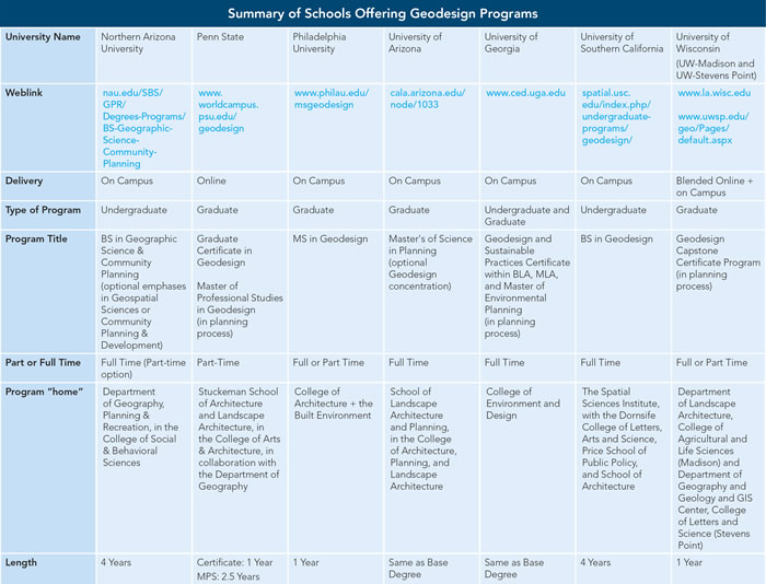
Seven programs in the United States responded to a short survey, the results of which illustrate an interesting variety of ways that programs are emerging (see table below). These schools are Northern Arizona University, Penn State, Philadelphia University, the University of Arizona, the University of Georgia, the University of Southern California, and the University of Wisconsin (UW-Madison and UW-Stevens Point).

A Diversity of Reasons to Start Programs
To begin with, there are a diversity of reasons why these programs got their start:
- Two, both of which are undergraduate programs, were part of larger university-level curricular revisions that sought efficiency by combining programs or encouraging interdisciplinary initiatives. These schools saw geodesign as an effective way to advance those goals while crafting a future-oriented program that brings together different disciplinary strengths from across the university.
- Two of the graduate programs decided to pursue geodesign due to the emerging trend and need for professionals who are knowledgeable about how to better integrate science with design.
- Three of the programs trace their roots to ideas and inspiration gained through attending the early Geodesign Summits.
- One evolved in response to a recent university strategic plan that outlined graduate education growth objectives.
- One hosted a geospatial summit that brought together educators and researchers from across the school system, which resulted in the new geodesign program.
Commonalities in Geodesign Education
Though, as we shall see, the different schools have designed their programs to suit their own needs, the programs do have in common several important points. All the schools do the following:
- Emphasize the integrated nature of their curricula, several feeling that the mix of science and design courses is balanced
- Offer an interesting array of related courses that are either required or available as options to geodesign students
- Include studio-based experiences for their students
- Include GIS components early, as either an introductory course in the first year or second year of the program (One program lists GIS as a prerequisite to enter, and it offers an accelerated GIS summer program for students without a GIS background.)
- Reference GIS skills throughout the remainder of the curriculum, which speaks to the stated goal of integrating science and design
A Variety of Formats for Geodesign Education
Despite these areas of overlap, these schools are embarking on geodesign education from a variety of approaches as evidenced in the results of the survey:
- Four universities are offering only graduate-level programs; two, only undergraduate; and one university will address geodesign at both levels.
- Within the area of graduate education, there is diversity: two will offer master’s degrees; there will be two stand-alone graduate certificates, and two of the programs will offer geodesign as a focus area or option for graduate students.
- All but two of the seven are resident programs.
- Two have online components; one is offered entirely online; and the other will have courses online, as well as some collaborative, face-to-face experiences.
Academic “Home”
While all schools make a point to emphasize the integrated nature of their curricula, it is not a surprise that a program’s academic “home” provides insight regarding the curricular mix of GIS/science and design:
- Two of the programs rooted in landscape architecture schools slightly favor design.
- One housed in a department of geography, planning, and recreation slightly favors geospatial sciences, with only one course specifically focused on urban/community design. However, they feel that design is “scaffolded” throughout the curriculum, with a focus on design history in other classes, and students who take the Community Planning & Development emphasis will do a required conceptual design in a capstone course.
- Another promotes strengths in data inclusion and spatial modeling and therefore has a mix of approximately two-thirds science and one-third design.
Studio-Based Experiences
Studio courses are unique educational environments rooted in problems-based learning (PBL). In PBL courses, students are presented with a problem and then become active participants—the content is not provided, but rather the students, either individually or in teams, discover and work with content they determine to be necessary to solve the problem. In PBL, the teacher operates more as a facilitator and mentor. The problems are typically open ended, and students learn through a guided, collaborative experience. All the programs surveyed mention the inclusion of studio-based experiences for their students; furthermore, the following are true:
- One has collaborative studios every semester.
- One offers a geodesign concentration where design applications are a culminating experience after other competencies have been developed.
- One incorporates design in the first year, followed by three architecture/design classes.
Optional Classes That Complement Geodesign
As discussed above regarding the likelihood that geodesign programs will develop their own specialties and emphases, the schools surveyed listed an interesting array of related courses that are either required or available as options to geodesign students. These include landscape ecology, communications and professional skills, public policy and regulation, professional and cultural values and ethics, quantitative sociology, heritage conservation, public participation and dispute resolution, building information modeling/CityEngine and other 3D visualization tools, sustainable design methods, and global issues (biodiversity, climate change, etc.).
International Advances
Of course, this article cannot be all-inclusive nor list all schools with new or developing geodesign programs either in the United States or internationally. Outside the United States (e.g., in China, Germany, Japan, Portugal, the Netherlands, and Thailand), there are numerous programs that adhere to the definition of geodesign education but may not use the term geodesign in the name. Some of these programs are housed within departments of landscape architecture, geography, urban ecology, engineering, and civil engineering. It will be interesting to track the evolution of new programs and degrees worldwide.
About the Author
Kelleann Foster, RLA, ASLA, is associate professor of landscape architecture; lead faculty for Geodesign Programs; and interim director, Stuckeman School of Architecture and Landscape Architecture, Penn State University.
For more information, contact Kelleann Foster.
See also “Confluence of Trends and Issues Actuates a Path for Geodesign Education.”
Related Podcast
The State of GIS in Education
David DiBiase, Esri director of education, talks about the integration of GIS in education, as well as new areas where geospatial technology is being applied.
Related Story Map
Geodesign Programs: A map tour of U.S.-based university programs integrating design and geography.

