Marion County, Oregon, which includes the state capital of Salem, is nestled among agricultural landscapes and residential communities that are home to nearly 350,000 people. One government department that supports this vibrant community is Marion County Public Works, which provides essential services such as road and bridge construction and maintenance, environmental stewardship, and outreach programs.
Among Marion County’s most celebrated events is its annual Earth Day Party in the Park, a cornerstone of community engagement and environmental education. Initially organized by the public works department’s Environmental Services Division in 2021, just as the community began returning to events and activities after the COVID-19 pandemic, the free Party in the Park is a more inclusive and community-oriented Earth Day celebration than past events. The party includes interactive educational opportunities, a terrarium-building activity, guided nature walks, face painting, and even a baby goat petting zoo.

“Our Earth Day celebration is more than just a gathering; it’s a reflection of our deep-rooted commitment to our community and the environment we call home,” said Stephanie Pulvers, an environmental specialist for Marion County. “Through engaging activities and digital initiatives, we aimed to not only connect residents with the beauty of Marion County but also foster a sense of ownership and responsibility towards its preservation.”
The challenge lay in extending the reach of this event beyond a single day. So staff at Marion County Public Works sought to implement a digital solution to share event details, engage with the community on a more regular basis, and spotlight ongoing sustainability initiatives. ArcGIS Hub ended up being the ideal product for the job.
A Dynamic, Interactive Digital Resource
The Environmental Services Division wanted to have a website that was interactive, user-friendly, mobile ready, and able to house links to multiple resources. Chosen for its versatility and ability to integrate mapping, Hub enabled the team to consolidate event and other information in a single digital space. Its customizable features allowed staff to tailor the site to the annual Earth Day theme and ensured a cohesive and engaging experience for the community.
To create the hub site, subject matter experts from Environmental Services, the GIS team, and the communications department came together to share their unique skill sets. Following a brainstorming session, the GIS team decided that the hub site needed to portray educational and event-related information in a user-friendly way to encourage community participation.
Graphic design played a crucial role in establishing the hub site’s visual appeal while ensuring that its look remained consistent with other communication materials. Most design elements were crafted using graphic design software and then added to Hub. The customizations worked with Hub’s thematic elements and created a cohesive aesthetic, ensuring that community members could easily recognize and connect with the event no matter how or where they accessed the information.
Throughout the development process, team members collaborated closely, sharing insight and learning from one another. The resultant hub site is a dynamic and interactive digital resource that showcases Marion County’s commitment to environmental stewardship and community involvement.
Activities Strengthen Community Connection
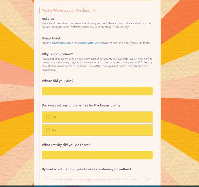
One of the sections of the hub site is the Passport to Sustainability, a keystone for extending Marion County’s 2023 Earth Day celebration throughout the month of April. It is a digital activity tracker that leveraged ArcGIS Survey123 to enable participants to complete various sustainability-themed activities. ArcGIS Experience Builder was used to display the results on the hub site in an appealing and accessible way.
Designed to combine educational goals with a game-like structure, the Passport to Sustainability made learning about environmental topics fun and rewarding. Participants engaged in activities crafted by subject matter experts from the Environmental Services Division—including cleaning up litter or using the Environmental Protection Agency’s How’s My Waterway app to learn about local watersheds—and earned points when they completed each task. Participants then redeemed the points for sustainable prizes from the county.
“The Passport to Sustainability was designed to make education engaging and to strengthen our connection with the community. We cover a wide range of environmental topics within our Environmental Services Division, and this initiative allowed people to explore many of them in a short amount of time in a fun and interactive way,” said Pulvers. “By gamifying the learning process, we aimed to inspire sustainable behavior change while ensuring participants enjoyed the experience. It’s a great way for the community to learn something new and see the breadth of what we do, all while having a good time.”

A Tracker for Participants and the County
The formcentric tools in Survey123 enabled the GIS team to consolidate all 24 activities in the passport into a single survey. By leveraging the app’s URL parameters, the team made sure that the survey only displayed the relevant questions for each activity on the website. Within the survey, participants created unique usernames that helped the county track individual user engagement. By employing hidden calculations, the survey seamlessly aggregated participants’ earned points based on their interactions with the questions.
“Upon survey submission, the results were instantly accessible as a hosted feature layer in ArcGIS Online,” said Chelsey Aiton, a GIS analyst for Marion County. “A filtered public feature layer view then exhibits essential details, such as usernames, activities, and point totals, while ensuring the confidentiality of other responses.”
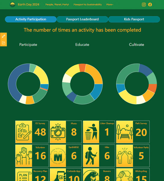
To present the cumulative passport participation results to the public, the team built a web app using Experience Builder. The app, which was embedded in a page on the hub site, had a dynamic bar chart that succinctly summarized the points each user had earned in a leaderboard format. This enabled participants to track their points and see what prizes they had earned. Additionally, interactive pie charts automatically computed and presented details on activity participation, showing the county how popular the activities were.
Ultimately, the Passport to Sustainability succeeded in engaging community members beyond a single day in 2023, giving way to a month of activities that fostered environmental stewardship. By integrating educational topics with fun activities, Marion County Public Works promoted sustainable practices, strengthened the community’s connection to the environment, and collected valuable feedback from residents.
Award-Winning Ideas and Technology
Marion County’s 2023 Earth Day hub site won two prestigious awards from the City-County Communications & Marketing Association (3CMA). The Earth Day event, along with its associated communication tools, won the Award of Excellence in the Go Green Communication Program Efforts category, while the Passport to Sustainability was honored with the Award of Excellence for Most Innovative Communications.
The Environmental Services Division put together another hub site for Earth Day activities in 2024 that garnered strong engagement again. Looking ahead, Marion County is committed to leveraging new ideas and technologies to further enrich its Earth Day events and broader program initiatives. Using ArcGIS to foster connections with community members empowers them to be environmental stewards and make a positive difference all year round.


