National hydrographic offices produce and maintain Electronic Navigation Charts (ENCs), which are essential to mariners and for navigational safety. They are used by marine freight operators to circumnavigate the globe, maritime pilot organizations to plan and optimize services and port entry, and coast guards and navies to support disaster response and law enforcement activities.
Many hydrographic offices are also now being asked to go beyond making charts and provide additional services, such as furnishing data for ocean research and monitoring and reporting on vessel traffic. Offices that already use ArcGIS Maritime for ENC production are well positioned to take on these challenges not only because the software supports a wide variety of product specifications but also because it seamlessly integrates with other ArcGIS products.

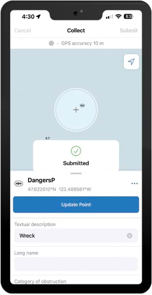
In particular, ArcGIS Maritime now integrates with ArcGIS Field Maps, an all-in-one app for mobile work that allows staff at hydrographic offices to take ENC production out of the office and onto the water. The pairing of Maritime with Field Maps enables survey crews to quickly report new information that is important for navigation, like dangers or obstructions. It also unlocks new capabilities for ENC end users, such as real-time alerting.
Maritime supports the creation, maintenance, visualization, and distribution of ENC data. When Maritime is used with Field Maps, users can inspect and update ENC data in real time or near real time. Moreover, Field Maps can leverage the services-based architecture of ArcGIS Enterprise, or it can be used offline in low- or no-bandwidth environments.
Providing Real-Time Updates to Chart Services
In their jurisdictional waters, port and inland water authorities rely on ENCs to ensure navigational safety for mariners, port pilots, and other people who navigate ports. The authorities frequently update ENCs to reflect changes to navigational aids and obstructions, and these updates need to be delivered quickly.
Traditionally, updating a navigational chart could take several weeks. Today, by using the ENC as a service maintained by national hydrographic offices, staff can make updates in real time.
For example, staff at an inland waterway authority can use Field Maps to update buoy locations with just a few taps on a tablet while they complete other inspection routines. The changes are then immediately available to everyone who uses that service. Likewise, after a natural hazard such as a hurricane, a port authority survey crew can help with cleanup efforts and accelerate a port’s safe reopening by using Field Maps to indicate new obstructions.
Giving Users Real-Time Proximity Alerts
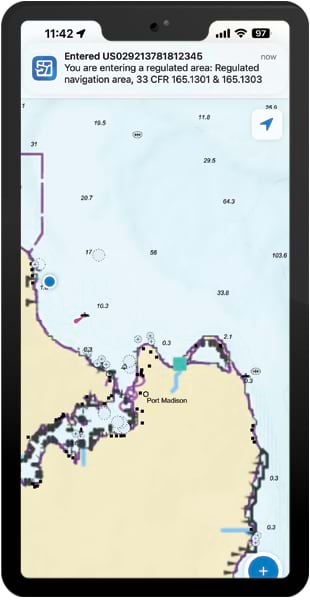
Hydrographic offices can provide additional value to their end users by combining ENC layers and the geofencing capabilities in Field Maps to enable real-time proximity alerts. Using Field Maps on their mobile devices, trusted users can access the geofence-enabled maps that hydrographic offices produce and host. When these maps are used with an electronic chart display information system, users on marine vessels can get real-time alerts on any of their devices that run Field Maps, which is available for free in the Apple and Google Play app stores. Depending on specific hydrographic offices’ requirements and regulations, access to these enhanced charts can be sold to generate revenue as well.
Shipping and commercial fishing companies that use ArcGIS Online or ArcGIS Enterprise can also employ the ENC services provided by organizations such as the National Oceanic and Atmospheric Administration to create geofence alerts for features on ENCs and their own configured overlays. For example, if a commercial fishing crew has identified a particularly rich fishing ground, the crew members can use Field Maps to mark that location on the chart and set up an alert to notify them of their proximity to the location on future expeditions. Additionally, while continuing to follow International Regulations for Preventing Collisions at Sea signals—which are maneuvering and warning signals designed to prevent collisions—commercial fishing, dredging, and diving vessels can set alerts for themselves or others for when a hazard is nearby or they reach a particular location.

Enabling Offline Editing for Survey Crews
Ideally, survey and inspection crews have constant internet connectivity via onboard broadband mobile services so that they can submit timely survey updates. However, given the nature of coastal and ocean work, including variable offshore distances and weather conditions, this is not always possible.
Field Maps allows users to take the Maritime Chart Service data that drives ENC displays offline and into a mobile geodatabase. This enables survey crews to use ENCs as basemaps and edit locations and feature attributes even when they don’t have internet connectivity. Features that are important for navigational safety, such as the locations of wrecks and other obstructions, can be added to the ENC database without having to wait for Maritime to process point clouds.
Crews can then update data and post changes when they get back to port. When an internet connection is reestablished, updates are processed nearly instantly, which boosts efficiency in chart production.
The Potential Beyond Producing Charts
Because hydrographic offices are being asked to provide more value to their end users, the ability to leverage more ArcGIS capabilities via mobile app integration is essential.
Apps such as Field Maps provide that integration right out of the box. Field Maps supports online and offline workflows, so survey crews can provide chart updates with or without network connectivity. And the Field Maps app’s geofencing capabilities can enhance ENCs with real-time proximity alerts.
Integrating Maritime and Field Maps opens the door for hydrographic offices to realize their potential beyond producing charts.

