For any organization that conducts field operations—whether the business is centered on field workflows or this happens as part of a larger enterprise—there are two fundamental requirements. Team members need to be able to leverage data and insights in a timely manner, and those carrying out field operations must have access to the tools and information they need to perform their jobs.
ArcGIS Field Maps does both. And since its release a little more than 18 months ago, the all-in-one app has gained key capabilities to better meet the needs of field teams. Organizations can use it to plan operations and coordinate their workforces, provide situational awareness to mobile teams, collect and edit business data, ensure people’s safety and meet regulations through location sharing, and synchronize office and field operations in near real time.

Recent updates to Field Maps boost organizational efficiency, empower mobile workers with new field capabilities, and support further integration with wider business systems and technologies.
Field Workflows Get More Efficient
While mobile operations range in scale—from conducting a single ecological survey to doing asset inspections across whole cities, states, and even nations—they all have one demand in common: efficiency. Building efficiency into mobile operations doesn’t stop once workflows are digitized, either.
In Field Maps, being able to capture and edit data in the field accounts for a large proportion of user workflows. That’s why recent updates have focused on improving how users build forms. Now, it’s possible to group related fields together and display fields conditionally, based on user inputs, so that mobile workers only see the fields and data required to do the work at hand.
Field Maps also incorporates calculated expressions, which enable mobile workers to automatically calculate and populate data in a form. Not only does this allow for rapid data capture, but it also minimizes data entry errors. Data is always valid, as these calculations are run every time a feature is created or edited. This reduces the time needed to do quality assurance on the data back at the office. Moreover, the data can be made operational within the larger organization in near real time.
Field Maps gives organizations the ability to deploy quickly as well, getting mobile workers what they need to get the job done. Organizations that use a mobile device management (MDM) system can automate a variety of user settings on managed devices, including how often mobile workers’ locations are synced with the app. The March 2022 release of Field Maps also made it possible to provide predetermined settings for high-accuracy workflows, so mobile teams no longer have to spend time configuring complex settings before using Global Navigation Satellite System (GNSS) devices.

Simple, Intuitive Design Empowers Mobile Workers
Members of a mobile workforce are often experts in their industries but not in GIS. For this reason, Field Maps has been designed to be intuitive and simple to use. And as mobile operations evolve, so do the capabilities of Field Maps—especially in the areas of location sharing, mapping utility networks, and indoor use.
Location Sharing
Keeping workers safe, following regulations, and synchronizing field-based and office work are primary reasons that organizations require mobile employees and contractors to share their locations. This capability is an integral part of Field Maps, and it works whether users are in a connected environment or in remote areas where coverage isn’t readily available.
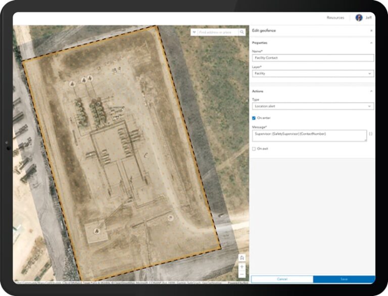
New geofencing capabilities, powered by geotriggers, enhance the location-sharing experience. When mobile workers enter or exit a geofence, the app can perform an action, like displaying a message or turning location sharing on or off. The purpose could be to notify mobile workers when they enter an ecologically sensitive area or inform engineers of parcel easements when they are conducting asset inspections.
In addition, geofences can determine the areas where users share their locations. This ensures that mobile workers stop sharing their locations once they’ve completed their tasks.
Utility Networks
Accessing digital utility records has traditionally been limited to desktop environments. But now that Field Maps supports ArcGIS Utility Network, comprehensive data about utility assets and networks can be accessed in the field from mobile devices. This enables engineers, for example, to query a digital twin of utility assets as they view easements and encroachments—all on the same map, all while on-site completing their tasks.

With Field Maps, users can also now view assets that aren’t normally visible on a map—like fuses that are contained inside a transformer bank—as well as how assets are connected to one another within a network. Additionally, field engineers are able to perform traces using Field Maps, which allows them to more easily respond to incidents, such as when employees of a water utility need to identify which valves to close to isolate a water main break.
Indoor Mobile GIS
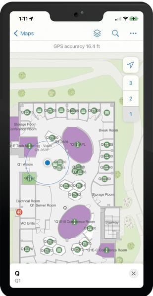
Increasingly, people want to be able to use mobile GIS inside buildings. This growing demand is encouraged by the wider availability of building information modeling (BIM) data and indoor positioning systems (IPS).
Field Maps is keeping pace with this demand. The app can leverage the ArcGIS Indoors model and is floor aware, meaning mobile workers can view indoor maps and filter information by floor. It is also possible for users to create floor-aware data and see their indoor location using IPS beacons, which is useful for conducting indoor asset inventories or fire safety inspections.
Linear Referencing
When inspecting assets along roads, railways, and utility lines, mobile workers often need to describe where the infrastructure is located by taking measurements from a fixed point using a linear referencing system. Now, Field Maps can find the measurement nearest to a mobile worker’s location or search for locations anywhere along a line. Found measurements like this can be captured by mobile workers when collecting information. They can also be used as destinations for driving directions or navigated to by using a compass.
Integration Capabilities Generate Smoother Workflows
Part of the appeal of using Field Maps is that it is agile and can be integrated with other technology—namely, high-accuracy devices and within wider business systems.

First, Field Maps works seamlessly with third-party devices, enabling mobile workers to more easily and expeditiously capture data and conduct other field-based duties. Field Maps allows users to leverage high-accuracy GPS and GNSS devices, as well as laser range finders, for projects that require submeter accuracy. The app was also recently integrated with InfraMarker from Esri partner Berntsen, which means mobile workers can scan a radio-frequency identification (RFID) tag on an asset and have Field Maps locate that asset automatically on a map.
Second, Field Maps can be integrated into wider business systems to streamline and automate workflows, including how maps are prepared and how they’re made available to mobile workers. ArcGIS API for Python enables organizations to use Field Maps to deploy maps and manage and analyze the data that’s collected in the app. Field Maps can also leverage webhooks, which are used to send notifications via email or text messages, post to social media, automatically write records to spreadsheets, and update enterprise databases. Additionally, App Links enable users to launch Field Maps from other applications with preset information, so they can get to work immediately.
The Future of ArcGIS Field Maps
The Field Maps team at Esri is focused on meeting the ever-evolving needs of the modern mobile workforce. This includes developing new and updated capabilities to make workflows more efficient, empower mobile workers, and enable deeper integration with other apps and devices.

