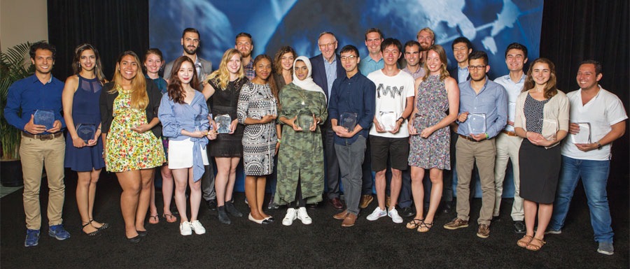
Esri has a vested interest in developing the next leaders in GIS. That is why every year, it hosts a group of students from around the world at the Esri User Conference who have produced exemplary work in GIS.
This year’s group of Esri Young Scholars hailed from 21 countries. Some are well-versed in using GIS, and others only recently encountered the technology. Some are still undergraduates, while others have graduated with their master’s degrees, and still others are pursuing PhDs.
All those who were able to make it were excited to attend the 2017 Esri User Conference in San Diego, California, and thrilled to present their work at the Map Gallery.
“The moment my project was displayed at the Map Gallery, that was the greatest moment,” said Serin Son, a GIS master’s student at Ewha Womans University in Seoul, South Korea, who used GIS to analyze the characteristics of traffic accidents involving females around Seoul to see how to improve driver safety.
The young scholars relished meeting their peers and networking with so many GIS professionals who have done tremendous work in their fields.
“I felt grateful to meet and make friends with my fellow Young Scholars from across the world, all connected by the same passion,” said Simon Haumann, a recent graduate of the University of Vienna’s master’s degree program in cartography and geoinformation, whose project on optimizing the operational range of electronic bikes in routing systems won him this year’s prize from Esri Switzerland.
Many of the students were also inspired by the advanced technology they witnessed in demonstrations—some of which they were even able to try out on the expo floor.
“I didn’t know what ArcGIS Pro was, but I learned here,” said Balca Agacsapan, an environmental engineer pursuing her PhD at Anadolu University in Turkey. The project she submitted to the competition used unmanned aerial vehicles (UAVs) and GIS to evaluate building rooftops at her university for their potential to conduct solar energy via photovoltaic panels. “In my next project, I want to use Drone2Map for ArcGIS,” an app she saw demonstrated at the conference.
Alan Pearse, an earth science and statistics major at Australia’s Queensland University of Technology, is excited about “the [ArcGIS] API for Python…that works with ArcGIS Online and ArcGIS Enterprise,” he said. “Just the fact that you can use Jupyter Notebooks and process your Python code on the fly and generate maps and do all your analysis in situ — I thought that was pretty awesome.” The project he submitted to the competition involved developing an ArcGIS toolbox that calculates spatially explicit watershed attributes to better analyze the effects that land use has on stream health.
To get to San Diego, the students submitted their projects to the Esri Young Scholars competition through the Esri distributors in their countries.
“Esri advertised at my university for students to present a project for the contest,” said Mauricio Grande from José Simeón Cañas Central American University in El Salvador. His project used Drone2Map for ArcGIS to quantify the impact that recent forest fires had on mountainous areas around San Salvador. “You have to work with one teacher from your university, and you have to present a work that is developed with Esri software. So you present your project, a poster, and a technical paper [to GEOSIS, Esri’s official distributor in El Salvador], and then you are in the contest.”
For Amelie Zehndbauer, who recently graduated with her bachelor’s degree in geoinformatics and satellite positioning from the Munich University of Applied Sciences in Germany, the process was a little different.
“I applied with my bachelor’s thesis,” which assessed the quality and user-friendliness of photogrammetric software, including Drone2Map for ArcGIS, she said. “An employee of Esri Germany helped me with my bachelor’s thesis and gave me the hint to apply for the Esri Young Scholars competition.”
Emily Acheson, who is currently getting her PhD from the University of British Columbia in Canada, applied with her master’s thesis, which she put together at the University of Ottawa. Studying the mosquitoes that carry malarial parasites in Tanzania, she mapped where the mosquitoes were located, as well as where mosquito nets were being used, and compared them to see if mosquito net distribution was matching the distribution of mosquitoes. It was not.
“We looked at indoor residual spraying, too,” she said. “We wanted to compare spraying to the nets, and we found that spraying does a good job at targeting mosquitoes.”
For someone who said she initially had no background in GIS, she has certainly centered her research on the technology.
“I took one course during undergrad that used ArcGIS, and I fell in love with the technology,” she said. “I wanted to find a way to use it in my PhD. I thought it would be a great tool to study disease distribution.”
And she is doing just that. Studying a killer fungus in British Columbia called Cryptococcus gattii, she is now using GIS to figure out why it is in Canada at all, since it is usually found in tropical places.
Being a GIS novice, yet becoming captivated by the technology, is not unusual among this group.
“I had no clue what GIS was before,” said Nael Al Hassanieh, who used GIS for the first time in his final project for his master’s degree, which he recently received in aeronautical engineering from the University of Balamand in Lebanon. For it, he and his colleague Michelle Nassar used 3D GIS for Beirut Rafic Hariri International Airport to create Obstacle Limitation Surfaces (OLS), which indicate the volume of airspace around an airport that needs to be free from obstacles, such as buildings, trees, and hills.
“The location of Beirut Airport is kind of sensitive because there are hills [and buildings] around it…and the sea from the west side,” said Al Hassanieh. “It was kind of a special project because it’s the first time this analysis has been done in Lebanon using GIS with high-accuracy maps,” which is ultimately why he decided to submit it to the Esri Young Scholars competition.
There are plenty of young scholars who got bitten by the GIS bug early, though.
Sander Varbla, from Estonia’s Tallinn University of Technology, started using GIS in high school.
“I was in eleventh grade the first time I realized that something like GIS exists,” said Varbla, who is more than halfway through his studies for a joint bachelor’s and master’s degree in civil engineering with a specialization in geodesy. “We had to do this research project with GIS, and my interest in it grew and grew.”
The project he submitted for the Esri Young Scholars competition revolved around improving the accuracy of global navigation satellite system (GNSS)-based bathymetric measurements in the Baltic Sea.
And Patricia Polo, an environmental engineering undergraduate student at the Latin University of Panama, encountered GIS early in her university studies.
“In the university, we do GIS, remote sensing, spatial analysis—all those subjects,” said Polo, whose project analyzed noise pollution in different areas of Panama City. She was so inspired by the people she met at the Esri User Conference that she plans to continue using GIS and is even considering getting a master’s degree in it.
Above all, the Esri Young Scholars were proud to present their work and energized by who they encountered and what they saw.
“This was just an amazing opportunity for me to showcase my research and see how it’s actually solving problems,” said Keneilwe Hlahane, a GIS and remote sensing master’s student in the oceanography department at the University of Cape Town in South Africa. For her project, she used GIS to monitor eutrophication (when rich nutrients, such as nitrogen and phosphorus, exist in excess in a body of water and alter the ecosystem), which is causing water quality in dams and rivers throughout South Africa to deteriorate. “This goes back to the theme of this year’s conference, Applying The Science of Where, which is what I’m doing. I’m applying the science of GIS within water quality resources.”
Hlahane, like so many Esri Young Scholars, left the conference with the drive to do even more.
“I’ve definitely learned a lot of things,” she said. “I’m going to try to apply some of the methods that I’ve seen here to my research to improve it.”
For more information about the Esri Young Scholars program, email Michael Gould, Esri’s global education manager.
Editor’s note: Some quotations in this article have been lightly edited for clarity.

