Lightning strikes play a major role in wildfires, which in the United States cause hundreds of billions of dollars in damages every year. About 53 percent of the average land area burned by US wildfires from 2018 to 2022 was attributable to lightning, according to the National Interagency Coordination Center. As hotter, drier conditions due to climate change raise wildfire risk and the speed at which fires can grow, it’s critical to have quick access to information on high-risk lightning strikes.
These are issues that Esri startup partner Fire Neural Network is addressing with help from ArcGIS Online and ArcGIS Dashboards. The company’s High-Risk-Lightning detectors provide location data on strikes that is then combined in ArcGIS Online with other wildfire-related variables. When viewed in dashboards, this data helps firefighting services allocate resources, such as deploying one of Fire Neural Network’s high-speed drones to take a closer look at the strike site.

When possible, Fire Neural Network also employs ArcGIS Hub to help communities incorporate lightning strike information into digital, GIS-enabled wildfire protection plans.
Why Lightning Detection Matters
From a wildfire perspective, not all lightning strikes are created equal. Lightning without rain, for example, is more likely to cause a wildfire. And long-continuing-current lightning strikes, which are relatively rare and can last up to 1,000 times longer than normal lightning strikes, are more likely to start a wildfire or damage power transmission lines.
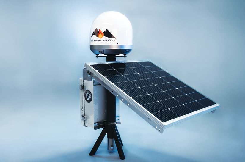
Fire Neural Network’s solar-powered lightning detectors pinpoint lightning strike locations and detect the presence of long-continuing-current lightning. The detectors are usually installed as an array of six ground-based units that collectively cover about 1,544 square miles (4,000 square kilometers). Connected to the company’s proprietary network, the detectors can identify lightning strike locations within 131 feet (40 meters) of the strike in 40 seconds or less. These are the only sensors on the market that can accurately detect the duration of a lightning strike and its associated heat characteristics.
To evaluate wildfire risk, Fire Neural Network uses ArcGIS Online to pair strike location vector data with more than 30 weather-related raster data layers—for flammability, humidity, vegetation, and rain data, for example—in real time. This data is then converted to a dashboard built with ArcGIS Dashboards and made available to subscribers in wildfire-prone areas such as California, Florida, Australia, and Brazil. From lightning strike to dashboard availability, this data is generally displayed in about 40 seconds.
Improving Wildfire Preparation and Communication
With a dry climate, plenty of flammable vegetation, and strong seasonal winds, the San Bernardino Mountains in Southern California are one of the most wildfire-prone areas in the United States, according to the US Forest Service. In fact, the Forest Service rates homes in San Bernardino County as having higher wildfire risk than 94.5 percent of counties in the nation. This is partly because a lot of areas in the county are part of the wildland urban interface—where developed communities and natural landscapes intersect.
To enhance fire response and preparedness, the San Bernardino County Fire Protection District began working with Fire Neural Network in 2023. The district’s goals were to improve stakeholder communication and involvement in wildfire preparedness efforts, including lightning detection and response.
The district already had in place a community wildfire protection plan, or CWPP, that outlines San Bernardino County’s wildfire risk-mitigation efforts. In addition to being better prepared for wildfires, communities with CWPPs are prioritized for federal funding to reduce the volume of flammable vegetation in the area.
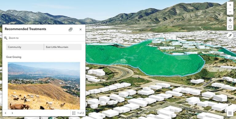
CWPPs are typically lengthy, highly technical documents that are distributed as PDFs—and they often fall short when it comes to improving community engagement. Considering this, San Bernardino County Fire Protection District fire chief Dan Munsey and deputy fire marshal Adam Panos wanted to transform their static CWPP into a dynamic and interactive online platform that integrates spatial analysis and can be updated in real time. Their goal was to give stakeholders access to up-to-date wildfire risk maps, recent mitigation projects, and resource allocation recommendations.
Fire Neural Network helps communities with this transformation by taking CWPP PDFs and converting them into GIS-enabled solutions. By using these solutions, community members can investigate current mitigation projects on hub sites created using ArcGIS Hub and use ArcGIS Survey123 to fill out mitigation recommendations or feedback forms for local fire departments.
San Bernardino’s new CWPP solution, which went live earlier this year, has been a success, according to Panos. “GIS-enabled CWPPs not only improve emergency planning capabilities but also ensure that vulnerable communities receive the support they need before and during wildfire events while enhancing community resilience,” he said.
ArcGIS Enhances Digital CWPPs and Enables Innovative Solutions
This GIS-enabled CWPP was Fire Neural Network’s eighth such project, following seven made with communities in Florida. All use Hub to show detailed maps and layers for current fire risks, historical fire and remediation data, and wildfire risk scenarios—along with information on lightning strikes if that information is available for the area covered by the CWPP. In addition to being used to enlighten communities and train fire departments and community leaders, digital CWPPs have aided communities in identifying high-risk areas that are susceptible to wildfire. With this information, community leaders can prioritize resources to mitigate social, economic, and environmental damage.
ArcGIS technology-enabled lightning detection also supports Fire Neural Network’s work with GatorX, a Florida-based partnership between the company and the University of Florida, NVIDIA, Satlantis, SwissDrones, Archer Aviation, SWIR Vision Systems, and N5 Sensors. GatorX has developed a solution that reduces risk for wildfire first responders. By using AI with satellite imaging, lightning and smoke sensors, and drones, the GatorX solution can quickly detect and verify hot spot locations before deploying a drone-tethered autonomous fire extinguisher that can put out emergent wildfires before they spread.
Benefiting from the Esri Startup Program
Based in Gainesville, Florida, and launched in 2021, Fire Neural Network joined the Esri Startup program the same year. The Esri Startup program helps early-stage startups incorporate location intelligence and mapping technology in their products.
“The Esri Startup program helped connect us to companies that are at the forefront of GIS analysis,” said Caroline Comeau, Fire Neural Network’s cofounder and director of marketing and finance. “This helped us further explore the connection between wildfires and GIS. It also exposed us to the many tools that are related to wildfire intelligence, as well as to using ArcGIS [technology] that can help explain this data to less technical individuals.”
In communities where GIS-enabled CWPPs have been implemented, local fire departments can deploy resources more strategically, and community members are more informed and prepared for potential wildfire threats.
And as the company continues to advance wildfire management technology, there is potential for further innovation. For example, Fire Neural Network’s robust AI and machine learning capabilities could provide precise predictions and alerts for wildfire management when dealing with devastating occurrences such as pyrocumulonimbus cloud events—when thunderstorms emerge in a wildfire’s smoke plumes. Both the predictions and alerts could help communities stay safe from major wildfires.
“By digitizing CWPPs and making them Esri enabled, we empower communities to enhance their emergency planning efforts and swiftly understand their risks when reacting to fires in these high-risk areas,” said Fire Neural Network CEO Dr. Istvan Kereszy.


