For organizations such as Diversified Energy Company (DEC, div.energy), a gas and oil production company operating in the eastern-central United States, mapping and managing underground energy pipelines are crucial to ensure efficiency and safety.
The manual methods previously used by DEC’s pipeline integrity group were often imprecise, which led to inaccuracies and delays in maintenance and repair. Since 2018, DEC staff have used ArcGIS products such as ArcGIS Enterprise, ArcGIS Online, and ArcGIS Field Maps to manage the company’s growing gas and oil pipeline dataset, including analysis to ensure system integrity and effectively run operations.
In 2021, DEC staff realized they needed to improve their system even more. They wanted a solution that could support analysis for determining pipeline locations and “classes” (official classifications based on characteristics such as pipe diameter and pressure ratings, local population density, and environmental sensitivity). Having this information would enable DEC staff to more quickly run new pipelines and perform system-wide analysis.

The solution needed to run on the latest ArcGIS products, support analysis of pipelines ranging from production sites to collection points to destinations such as refineries and processing centers, and be flexible enough to perform analysis on datasets undergoing data review and cleanup. In 2021, DEC turned to Agere Integrity.
Managing Operations with Cutting-Edge Technology
Based in Atlanta, Georgia, Esri Startup Program graduate Agere Integrity was founded in 2020 to provide companies like DEC with the tools to manage operations safely, reliably, and efficiently, using the latest technology. Agere provides Esri-based applications to perform and manage pipeline system analysis as part of an enterprise solution, allowing for continued improvement of data over time.
With Agere’s help, DEC launched an application that supports all requirements of the Pipeline and Hazardous Materials Safety Administration, a US Department of Transportation agency that develops and enforces regulations for transporting energy and other hazardous materials. Agere’s solution worked with the existing components of DEC’s ArcGIS Enterprise solution and included an ArcGIS Pro add-in. This add-in provided basic interfaces to create and manage various pipeline class analysis projects. An Agere high consequence area server was added to analyze various pipeline characteristics.
The new system allows DEC to efficiently run thousands of routes quickly and accurately through algorithms for different pipeline types, storing results using the ArcGIS Pipeline Referencing extension.
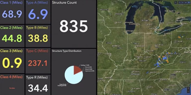
Now DEC staff can identify data gaps and errors that need to be addressed, including GIS-based issues such as overlapping pipelines and missing critical attributes. DEC staff can also incorporate new dwellings and structures (captured with ArcGIS Field Maps) or newly acquired assets. This helps staff understand the full scope of DEC operations and target focus areas. Up-to-date results are shown on ArcGIS Dashboards.

By partnering with Agere, DEC has been able to perform and manage class location and consequence analysis of its entire piping system across nine states and over different pipeline types and classes, according to DEC lead GIS analyst Jason Stanley.
The Agere solution has assisted DEC staff with about 20 asset acquisitions by enabling analysis that helps quickly identify key focus areas such as gathering lines, which are pipelines that are used to move natural gas from wells and production facilities to transmission pipelines, which then transport the gas to downstream distribution systems. Since the results are archived after each run, DEC staff can review the changes in an area over time, allowing trend evaluation for high-growth areas to prepare for future reclassifications.
“Agere Integrity’s solution has given us the ability to quickly navigate through our piping system during state audits,” Stanley said. “It has also given us a data repository that can be used for operations to make real-time decisions during abnormal operations. We use it during acquisitions to give us a quick and easy way to see the regulatory impact to the company.”
Deploying the Agere solution in conjunction with ArcGIS allowed DEC to have a central data repository where everyone in the organization can view the latest results. DEC staff now have a central and up-to-date dataset that can be demonstrated to auditors when requested.

