Esri Press e-books are available through the Esri Books app or from online retailers. For information on all Esri Press publications, visit esri.com/esripress.

Mapping and Modeling Weather and Climate with GIS
Edited by Lori Armstrong, Kevin Butler, John Settelmaier, Tiffany Vance, and Olga Wilhelmi
Weather mapping goes beyond what is broadcast on the evening news. Mapping and Modeling Weather and Climate with GIS describes how GIS technology can be coupled with atmospheric and climate sciences data to do research. The book is aimed at meteorologists, climatologists, and GIS practitioners interested in integrating weather and climate data into their GIS workflows. Early chapters cover how modeled atmospheric data and weather radar can be used in ArcGIS. A chapter describes on how weather- or climate-related social media feeds and posts can be integrated into a GIS and used in research. There is also a five-chapter section on tools and resources such as Python scripts and the Weather and Climate Toolkit, free software from the National Oceanic and Atmospheric Administration (NOAA) National Climatic Data Center. Esri Press, 2015, 370 pp., ISBN: 9781589483767

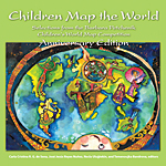
Children Map the World: Selections from the Barbara Petchenik Children’s World Map Competition
by Carla Cristina R. G. de Sena, José Jesús Reyes Nuñez, Necla Ulutekin, and Temenoujka Bandrova, editors
Children Map the World: Selections from the Barbara Petchenik Children’s World Map Competition presents 70 maps created for the 2013 International Cartographic Association map design competition by children ranging in age from 3 to 15. These hand-drawn, sewn, or assembled maps convey powerful messages of optimism, anxiety, tolerance, and hope that reflect the competition’s most recent theme “My Place in Today’s World.” This anniversary edition also showcases maps from past competitions that were held from 1993 through 2014. Children, parents, teachers, and map enthusiasts will delight in the work of these imaginative young cartographers. Their representations of the world and their lives demonstrate perspectives that vary from optimistic to pessimistic. April 7, 2015. 108 pp., Paperback ISBN: 9781589484221

Python Scripting for ArcGIS
by Paul A. Zandbergen
Python Scripting for ArcGIS is a guide for experienced ArcGIS for Desktop users that will get them started using Python scripting without requiring that they have previous programming experience. Experience with other scripting or programming languages, such as Perl, Visual Basic for Applications, VBScript, Java, or C++, is helpful but not required. Readers should have basic ArcGIS skills and an understanding of geoprocessing procedures. This book replaces the previous edition and moves the resources for the exercises online. The book’s 14 chapters have corresponding online data and exercises that are available from the Esri Press book resource page. 2015. 358 pp., Paperback ISBN: 9781589483712

GIS Research Methods: Incorporating Spatial Perspectives
by Sheila Lakshmi Steinberg and Steven J. Steinberg
GIS Research Methods: Incorporating Spatial Perspectives shows researchers how to incorporate spatial thinking and GIS technology into research design and analysis. Topics include research design, digital data sources, volunteered geographic information, analysis using GIS, and how to link research results to policy and action. The concepts presented in this book can be applied to projects in a range of social and physical sciences by researchers, whether they are using GIS for the first time or are experienced practitioners looking for new and innovative research techniques. Scheduled for publication on May 1, 2015. 540 pp., Paperback ISBN: 9781589483781 and e-book ISBN: 9781589484047

