With their expertise in implementing GIS solutions that incorporate advanced analytics, 3D modeling, and state-of-the-art data management systems, Esri partners are helping their clients set examples in their own industries. Read on to find out how three partners are blazing trails in aiding utilities with location-based risk analysis, building digital twins for sustainable development, and slimming down still-robust imagery operations.
A Novel Way to Determine Risk of Failure
In Raleigh, North Carolina, it was becoming increasingly difficult for the city’s public utilities department, known as Raleigh Water, to conduct efficient risk management on its 2,340-mile pipeline network. Utility leaders sought a partner that could help them gain greater visibility into water pipeline conditions, more accurately predict which pipes were in danger of breaking, and more efficiently prioritize capital works projects. Xylem, which delivers innovative solutions to solve water problems, fit the bill.

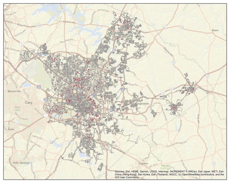
Using its Asset Performance Optimization solution, Xylem’s team of industry and technical experts conducted a probability analysis on Raleigh Water’s entire network, which includes more than 88,000 individual pipe segments. The team combined historical data on pipeline breaks with other infrastructure information that the utility maintains in ArcGIS Enterprise—including the location, size, length, and material of all of Raleigh Water’s pipelines—to identify 16 specific 1.5-mile sections of pipeline that contain the greatest number of pipe segments at risk of failing.
Incorporating location intelligence into advanced risk analysis provided Raleigh Water with a more accurate, predictive, and targeted view of its network’s potential trouble spots than it could have achieved through traditional analysis methods. To date, Raleigh Water has used Xylem’s probability-of-failure and cluster analysis results to plan six capital renewal and smart meter projects—and the utility continues to employ the solution to develop more efficient asset management strategies. It is estimated that the work done with Xylem has reduced project planning time at Raleigh Water by about 75 percent, saving the organization up to five days for just this part of the process. The implementation has also cut down on the number of pipe breaks that have occurred across the network.
In addition, Raleigh Water is using this data-driven understanding of pipe failure risk to place smart sensors that gauge water pressure on key pipe segments. This removes any potential for bias when determining where to do capital improvement projects, ensuring that no communities are neglected when it comes to upgrading infrastructure.
As one of the first utilities in North Carolina to use advanced risk analytics, Raleigh Water is proactively working on behalf of its customers, using data to achieve new levels of network visibility and drive asset intervention plans that reduce breaks and increase operational efficiency.
A Digital Twin for City Planning
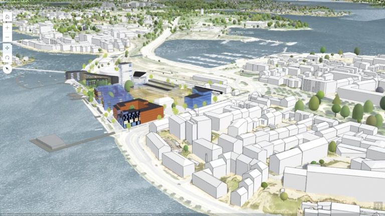
In Karlskrona, Sweden—a United Nations Educational, Scientific and Cultural Organization (UNESCO) World Heritage Centre—the Environmental and Public Works Administration has set out to establish a digital twin of the city by 2030. The goal is to use the digital twin as a 3D city information model (CIM) and data-driven test platform for city planning, which will help city leaders better consider ecological, social, and economic sustainability options.

The city called on its long-term partner S-GROUP Solutions, which specializes in building GIS solutions for local governments, to help make the digital twin. Because the City of Karlskrona has invested in an Esri Enterprise Agreement (EA), along with GEOSECMA for ArcGIS, a commercial off-the-shelf (COTS) solution from S-GROUP Solutions, the Environmental and Public Works Administration was able to use ArcGIS technology as the foundation for its digital twin. ArcGIS Pro and ArcGIS Urban are particularly important for visualizing the 3D model.
GEOSECMA for ArcGIS provides the CIM with Karlskrona’s domain data, which covers the city’s road networks, its water and sewer grid, comprehensive zoning plans, tree inventories, playground inspections, and more. Not only that, but GEOSECMA for ArcGIS also has built-in and continually updated support for Swedish regulations, helping the city ensure that its designs correspond to national planning laws. This enables staff at the city to use the data in the CIM to perform accurate, scenario-based GIS analyses—which can be used to model city silhouettes, conduct studies on noise and shadow changes, determine construction rights, and more—to help leaders make smarter decisions about sustainability. Together, the CIM and digital twin allow staff in the Environmental and Public Works Administration to create, test, and build everything in a virtual environment. When the results correspond to Karlskrona’s sustainability goals, construction of the physical environment can begin.
Thus, using GIS allows city leaders to increase citizen services; optimize building rights; decide on the most suitable locations for new schools, housing, and industry; and consider the environmental effects, people’s safety, the perspectives of children, and other important factors of city plans.
This kind of thoughtful urban design has made the City of Karlskrona a role model in Sweden for the use of digital twins, which is especially important considering that the Swedish government has set goals for developing digital community building processes. The aim is to create simpler and more transparent, democratic, and efficient planning and construction processes that benefit residents and private companies—something that Karlskrona is already doing.
A Streamlined Imagery Management Strategy
The United States Marine Corps (USMC) Installation Geospatial Information and Services (IGI&S) program, known as GEOFidelis, needed a new imagery management strategy to support the transition to an enterprise implementation with increased analysis and dissemination capabilities. The program’s existing imagery holdings were managed locally in various storage formats without set naming conventions or common standards and procedures.

To help with this endeavor, geocgi worked with GEOFidelis to implement imagery management standards and design a corresponding solution based on ArcGIS Image Server and mosaic datasets. Initially, the team at geocgi focused on reducing the storage footprint of the 500 million acres of raster coverage that GEOFidelis had. Implementing mosaic datasets reduced storage space while allowing for easier user access, more visualization and analysis options, more flexible data management, improved performance, and enhanced dissemination of imagery and raster datasets across the USMC.
After the storage issues were remediated, the geocgi team analyzed the program’s existing raster datasets to determine gaps in coverage, currency, or format, as well as how users typically accessed raster data. This enabled the team to specify where to direct service resources and how they should be utilized. geocgi deploys and manages a fluctuating number of image services that it analyzes and reviews quarterly for usage to maintain server stability, averaging about 80 services per quarter. Based on frequency of use and importance, certain image services can be demoted, or stood down, to reduce storage costs.
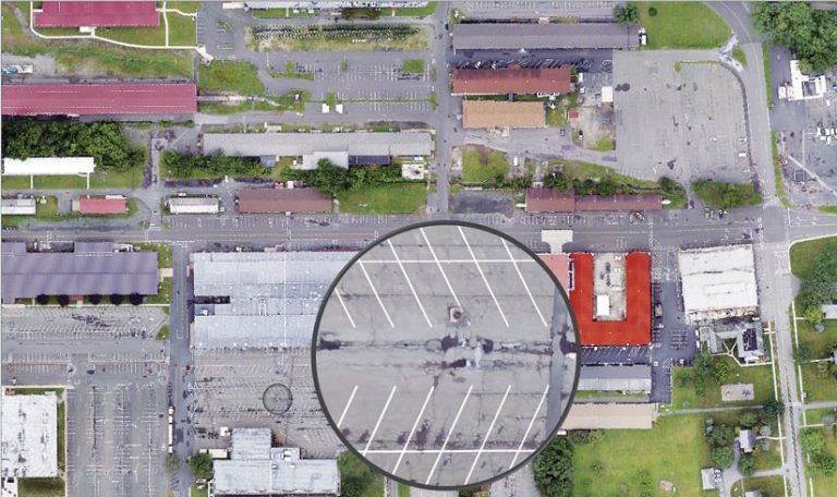
To better manage its imagery in the future, GEOFidelis is focused on acquiring imagery by leveraging collections from small unmanned aircraft systems (sUAS) and mosaic datasets. The goal is to figure out where GEOFidelis can save on costs for imagery while still meeting the program’s requirements for refreshing imagery. To this end, GEOFidelis is concentrating image capture on areas that have changed rather than on entire installations. This allows imagery updates to be delivered to end users quickly to support functions such as emergency management, facilities management, and construction. In addition, the sUAS technology and mosaic datasets support on-the-fly processing, which makes it possible to get new imagery acquisitions to decision-makers without delay.
Through scripting and batch process development, geocgi has increased the raster services that are available to the USMC by 588 percent and improved service load times by 29 percent.

