When organizations need to make swift or long-term changes to how they use, gather, store, and manage spatial and nonspatial data, it can be advantageous to work with outside experts that know how to build, integrate, and maintain new systems. That’s exactly what Esri partners are equipped to do.
Find out how Esri partners Safe Software, DCSE, and HDR helped three organizations develop new and innovative GIS implementations that meet their changing needs, from gathering data in a war zone to extending GIS throughout the enterprise.
Using Open Data to Clear Land Mines in Ukraine
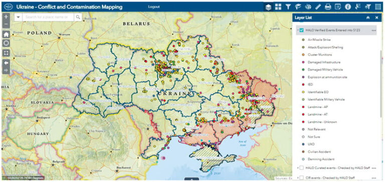
Since 2016, The HALO Trust—the world’s largest land mine clearance charity—has been embedded in communities in eastern Ukraine to clear mines from the armed conflict between Russian-backed separatists and Ukrainian forces that began in 2014. When Russia launched a full-scale invasion of Ukraine in February 2022, HALO had to halt those operations and move to the capital of Kyiv, where fighting was less intense, to better respond to the urgent and expanding need to clear mines around the country.

Gathering data in the field on land mines was now out of the question, so HALO needed to quickly change its approach to focus on digital data collection. Staff members suddenly needed to augment the organization’s existing ArcGIS technology-based web maps with live, open-source data.
To make this work, the HALO team wanted to use a data integration tool that could automatically extract, transform, and load (ETL) large amounts of data. HALO staff were aware of Safe Software and its FME Platform, which automates ETL operations for diverse data types, including open data—no coding required. So the team reached out to Safe Software and got the system up and running.
Today, HALO uses FME Platform to collect information about different types of incidents around Ukraine that involve explosive ordnance. The software scrapes social media sites and data aggregators, processes and geolocates the data, and publishes the data on HALO’s ArcGIS technology-based web maps. Every few hours, APIs automatically pull new open-source data and process and publish it on the interactive web maps. This allows field operations teams, HALO executives, government donors, and international stakeholders to use the maps to find out where there are threats, contaminations, and confirmed munitions throughout Ukraine.
While HALO has been able to resume field-based operations in Ukraine in areas where fighting has ceased, the organization still employs these automated data workflows to reduce manual work, eliminate duplicate assignments, reduce human errors, and save time. HALO now plans to integrate this new data management system in the 25 countries it works with that have national mine action databases. The organization will use FME Platform in these environments to connect and automate the flow of data between ArcGIS Survey123, ArcGIS Enterprise, and the PostgreSQL database management system.
Streamlining Mobile Data Collection to Mitigate Risk
The San Bernardino Municipal Water Department (SBMWD) has operated and maintained the sewer collection infrastructure in San Bernardino, California, since it took that over from the city’s public works department in 2017. For years, the SBMWD sewer collection team, which maintains sewer lines, struggled to track its work using an outdated paper- and spreadsheet-based system. Having to manually fill out paperwork to show which areas had been cleaned and where future cleanings needed to take place made it difficult for the team to meet its line cleaning and sewer spill avoidance goals.

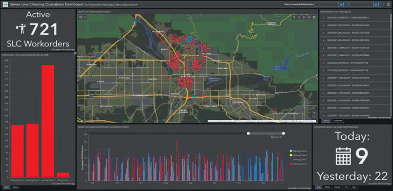
To improve the planning, data capture, and reporting processes for this work, SBMWD sought a GIS-based solution that would allow a range of staff members from diverse backgrounds and with varying levels of computer proficiency to visualize their progress and plans. Collaborating with DCSE and its partner, Spatial Wave, SBMWD implemented an ArcGIS technology-enabled Mobile Asset Management System (MAMS) that allows users to better plan, schedule, assign, and perform sewer line maintenance while tracking the resources that get used.
The MAMS has access to SBMWD’s GIS data, associated engineering documents, and the sewer lines’ closed-circuit television (CCTV) feeds. It links data collected in the field with the department’s GIS and publishes that in ArcGIS Enterprise. Employees in both the field and the office can then use a dashboard, built with ArcGIS Dashboards, to monitor progress on sewer line cleaning, and supervisors can use it to plan future operations.
A significant benefit for SBMWD is that the MAMS uses ArcGIS Runtime SDKs for .NET and iOS to publish the GIS data for mobile use. This enables the sewer collection team to display digitized field data using symbology that’s similar to what mobile crews saw on old hard-copy maps generated in ArcGIS Desktop. It also helps seamlessly publish the data in ArcGIS Enterprise and display real-time progress via the dashboard.
Although it was a significant change to switch from a paper-based system to a GIS-centric solution, employees adapted quickly after taking part in training sessions. With all its sewer line cleaning data centralized and accessible in ArcGIS Enterprise, SBMWD has improved communication among departments. Now, supervisors and mobile crews can visualize critical information—including as-builts, cleaning history, and CCTV data—all in one digitized, geospatially focused system.
SBMWD estimates that the MAMS has saved staff members hundreds of hours each year in looking for the history of sewer line cleaning data and communicating their work progress with colleagues and supervisors. Ultimately, the system supports SBMWD’s goal of conducting timely sewer line cleanings and avoiding environmentally damaging and costly sewer spills.
Implementing a Future-Oriented GIS Plan
The City of Billings, Montana, has a vision for developing a connected, data-driven community. This vision relies on being able to accurately collect and manage live data.

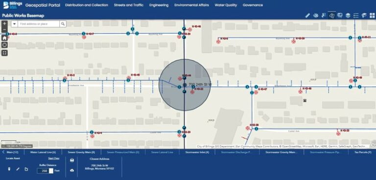
For the last 20 years, Billings has had a relationship with engineering firm HDR. Billings recently relied on HDR to build basemaps and create hundreds of asset management layers in ArcGIS Pro, ArcGIS Enterprise, and ArcGIS Online to improve service delivery to residents. So when the city created its new Billings GIS Plan, staff members asked a team at HDR to assess and implement the plan.
The HDR team started by doing a systems and data review of the public works department’s production GIS environment. This review included evaluating the city’s current GIS data and IT infrastructure in relation to map performance, data access, workflows, and third-party software integrations. The team also carried out a detailed review of the public works department’s GIS data, looking for gaps in completeness, accuracy, and consistency. The results of the assessment were summarized in an ArcGIS StoryMaps story, with data gaps, potential issues, and recommendations presented in maps and as key takeaways.
Next, the team from HDR worked with staff from the Billings public works department and GIS professionals at the city to prioritize its recommendations in a GIS road map and begin implementing them. Projects outlined in the road map included foundational priorities, such as improving GIS governance, updating data schemas, making database upgrades, and deploying ArcGIS Enterprise. Once these foundational improvements were in place, the team implemented a suite of updated ArcGIS Online apps, such as ArcGIS Dashboards and ArcGIS Hub; conducted an ArcGIS Utility Network pilot project that used feature manipulation engine workflows for data migration; and modernized the city’s technology from Esri partner Cityworks. The team also implemented automatic vehicle location tracking for the city’s snowplows and integrated Montana’s Call Before You Dig program with ArcGIS and Cityworks.
Now that the Billings GIS Plan is going strong, teams from HDR host GIS training workshops for city staff. These initiatives amplify the city’s use of GIS and help streamline business operations across all divisions within the public works department.
At the 2022 Esri User Conference, the City of Billings received a Special Achievement in GIS (SAG) Award for this ongoing project.

