For more than a century, Swiss National Park (SNP) has upheld a powerful promise to nature—to mostly leave it alone.
Established as a countermeasure to European industrialism in the early 20th century, SNP lets ecosystems exist and evolve in their purest form. Under the protected area management guidelines of the International Union for Conservation of Nature, Switzerland’s sole national park is designated as a “strict nature reserve.” This rigidly limits human visitation, use, and impacts by requiring visitors to stay on hiking trails and prohibiting camping, off-trail hiking, and hunting.
-
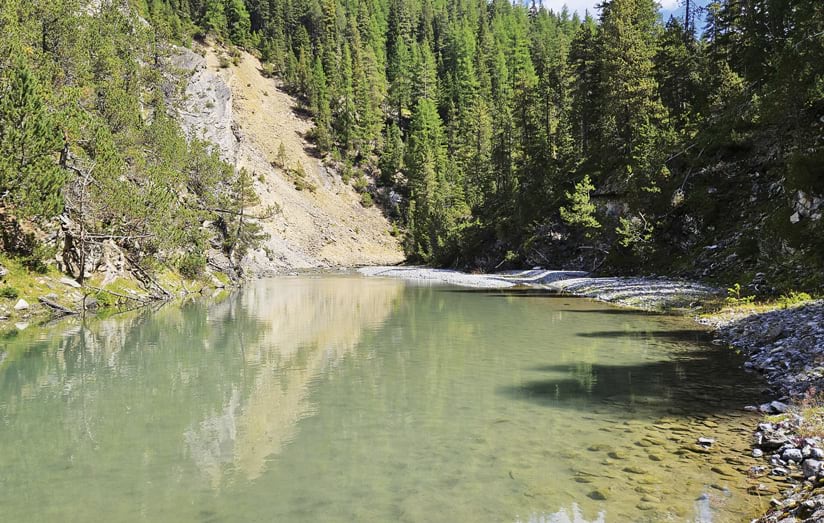
GIS was used to determine which areas of the River Spöl should be marked for restoration.
Since 1992, staff at SNP have used GIS to manage this pristine protected area. Over the years, SNP’s enterprise-wide GIS has advanced and expanded to include a robust implementation of ArcGIS Enterprise and the use of apps such as ArcGIS Field Maps. This technology aids SNP with operational management, infrastructure planning, data collection and sharing, flora and fauna monitoring, mapping, and analysis. It is key to helping the park achieve its goals of protecting natural processes, fostering scientific research, and educating the public.
“GIS supports all of these pillars,” said SNP director Dr. Ruedi Haller, who began his career at SNP in 1997 as a GIS specialist. “All park information is spatially related in some way.”
A Haven for Research and Data Collection
SNP’s wilderness offers ideal research conditions for park researchers and those from outside institutes. The national park serves as an open-air laboratory where scientists can study alpine plants and environments with minimal human interference. Over the past four decades, the SNP GIS team has accumulated more than 1.5 petabytes of data that encompasses thousands of individual datasets.
About 2,000 records are now stored in the public-facing SNP Data Center, including vector and raster GIS layers, satellite imagery, drone-captured orthophotos, analog maps, and other data related to the park. Interested parties can access the metadata of these GIS datasets by browsing categories such as projects and long-term monitoring information or by searching for specific topics including the environment or biota. The data center also offers geographic context and data to assist with spatial planning and park management in Switzerland’s 19 regional parks, which make up 14 percent of the country’s land area.
The most common way to find information on SNP’s geodatabase is to perform a keyword search. For instance, if a user searches for the words “drone” and “Cluozza”—the oldest and wildest valley in SNP—the database yields 10 results: images from drone flights taken over the valley between 2017 and 2023.
Amassing this wealth of information has taken decades, but new geospatial tools have made the process of gathering data more accurate and accessible. SNP rangers and researchers now use Field Maps, for example, to streamline data collection. With preconfigured digital maps and forms, mobile workers can easily locate and capture information on topics such as morphological changes happening in the area and park signs that need to be repaired.

Making Robust Data Available in the Field
Since internet connectivity in the park is sparse and data collection is often done offline, the GIS team used an Esri vector tile package to develop a custom SNP basemap. Field staff can save this robust, dynamic digital map to their smartphones before entering disconnected areas and then use Field Maps to collect and edit information no matter where they are.
Dr. Samuel Wiesmann, head of GIS and information communication technology at SNP, emphasizes the value of visualizing data on a map. “If you can show it on a map,” he said, “it brings the data together and makes it much easier to understand.”
With Field Maps, users have all the data they need to conduct planning, analysis, and discussions in the field—regardless of their expertise in GIS, geography, or biology. This has greatly enhanced communication and collaboration between office and field staff at SNP, since they all have access to the same, consistently updated data.
For instance, when tracking the growth stages of plants—such as leaf sprouting or flower blooming—it is now clear which plants have been documented and which plants still need to be observed. Additionally, SNP staff have an easier time managing the more than 600 signs posted throughout the park, since each sign’s status is visible to all stakeholders at any given moment.
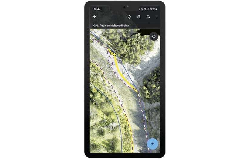
Another notable application of Field Maps at SNP was its use in defining the remediation perimeter of the River Spöl, a Swiss and Italian waterway that’s been affected by polychlorinated biphenyl (PCB) contamination. In Field Maps, a blue line showed the maximum height of a hydrologically simulated flood, while a purple-and-white dashed line indicated a possible remediation perimeter based on orthophoto analysis.
The SNP team and the engineers overseeing the remediation project were able to visually compare the two proposed boundaries in Field Maps with conditions on the ground. SNP employees also used the app while on-site to quickly record all the descriptions, explanations, and decisions related to the boundaries. This enabled the SNP employees and engineers to jointly define the river’s remediation perimeter, which is represented in Field Maps using a yellow line.
“Before [using Field Maps], rangers brought back paper reports that had to be digitized,” Haller said. “You had to make sure there was no error in it.… There was uncertainty. The precision has improved a lot with these modern applications.”
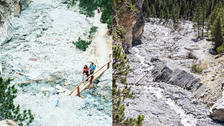
Historical Records Enable Keen Observations of Natural Processes
Observation areas were established in the national park as early as 1917, giving researchers and SNP staff access to an astonishing cache of historical records. Manually logged data, such as insight on red deer and ibexes from the 1920s and aerial photographs from the 1940s, assist in current observations of natural phenomena. SNP staff have converted analog historical records into digital spatial datasets for easier visualization and analysis within ArcGIS.
Haller and Wiesmann have prioritized observing and recording the natural processes in SNP to gain a deeper understanding of the origins and effects of these phenomena. The national park is preparing to hold an exhibition at its visitor’s center in 2025 to showcase how the landscape has changed since the area became protected.
In preparation, SNP staff members have curated a collection of photographs of the park from the 20th century, focusing on the 1920s and 1930s, and identified their corresponding locations. Wiesmann and his GIS team mapped these locations and created data collection forms to assist field teams as they capture modern-day comparison photos. Equipped with Field Maps, park rangers can locate the area in question and view the original photo and its metadata so that they can accurately position their cameras to take a matching photograph.
“Field Maps has helped us with planning,” said Wiesmann. “When we have four or five people involved in this work, it helps to have such a tool on a web map or a dashboard.… We can see where somebody has been and if a photo needs to be redone.”
Wiesmann and Haller want these photos to tell stories. Seeing the progression of a tree line, for instance, adds to a larger narrative—one of restoring nature.
“We are on the way to a wilderness area back from a cultural area,” said Haller.
A Digital Guide for Visitor Education
SNP is closed to the public for seven months out of the year, but between May and October each year, more than 100,000 visitors explore the park. Hikers and adventurers of all ages can use the Swiss National Park app to enrich their experience.
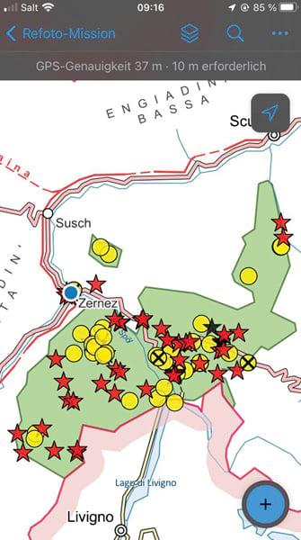
The app has evolved significantly since the first iteration was released almost 20 years ago.
“We launched the first public-facing version in 2005,” Haller said.
His team’s forward-thinking, location-based service steadily evolved into the dynamic, mobile app that’s available today. The app integrates Esri vector tile basemaps using ArcGIS Runtime SDK for iOS and ArcGIS Runtime SDK for Android. It offers a range of functionalities, such as comprehensive hiking route descriptions and altitude profiles, labeled points of interest, details about wildlife, and panoramic views of the park’s most breathtaking regions.
Some features are designed to delight and engage SNP’s youngest visitors as well. Along the Champlönch children’s trail, for example, hikers can pair the app with a special booklet to receive audio recordings at 10 different points of interest. Animated characters appear in the app to share stories about nature. For instance, a red deer explains in an audio recording what it does to combat the heat in the summer and what conflicts animals have with each other.
SNP also hosts an annual summer camp, offering young students an immersive experience in the park. Camp participants get to experiment with GIS-based apps and tools and learn how maps and analysis assist in managing park projects. Connecting with young audiences helps SNP staff ensure that future generations appreciate the importance of protected areas.
As SNP continues to prioritize conservation, research, and education, GIS will remain a vital component for documenting and preserving the alpine ecosystem for years to come.
“That’s one of the good things about GIS,” said Haller. “If you store [and visualize] your spatially related data, you can have a long-term history of everything.”
