The power of location has fascinated Claire Yates for years. Now the driving force behind Vision Zero Louisville, the Kentucky city’s safety initiative that envisions zero roadway fatalities by 2050, Yates has built her career around what she calls “designing for good.”
“I became very interested in the built environment and how infrastructure and developers shape the communities that people live in,” she said. “I really enjoy this kind of marriage of real estate, the built environment, and human nature.”
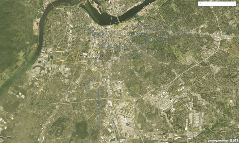
In her current roles as transportation planner for Louisville Metro Government and its Vision Zero program manager, GIS is central to Yates’s work. She meticulously records and maps every crash in Louisville that results in death or serious injury and shares this data with the public. She also creates and maintains datasets that support her work. These include roads that have been or are planned to be rightsized to make driving on them safer, as well as uncontrolled, midblock crossings to help determine where new pedestrian crossing infrastructure is needed.

“We use GIS to determine where we should invest our limited time and resources,” she said.
Yates has also employed GIS to bring in more than $29 million in federal funding to improve Louisville’s roadways for motorists, pedestrians, and bicyclists.
“Claire figured out how GIS can support Louisville’s efforts to improve road safety, and she has continued to use the technology to bring in more funding,” said Oscar Loza, senior marketing manager for industry solutions at Esri. “Her efforts—and successes—are inspiring.”
Flares of Geospatial Brilliance
Fresh out of college, Yates was working as a paralegal for a real estate development company, trying to decide if she wanted to become a lawyer. She concluded that practicing law wasn’t her calling, and she wasn’t enthusiastic about the big-box-store-anchored strip malls that the company tended to develop. But Yates did find urban planning fascinating. So she enrolled in the urban studies master’s degree program at the University of Louisville. That’s where she first encountered GIS.
Yates took an introductory GIS course and found the instructor, Bob Forbes, “absolutely wonderful,” she said. “He was just very methodical…about getting us acquainted with new programs and a new concept like GIS.”
She was hooked, so she took several more GIS classes.
“That really opened my eyes to the kind of power that GIS has and what you can do with it using different datasets,” she recalled.
Since learning ArcGIS technology, Yates has brought her own flare of geospatial brilliance to all the roles she’s held. After graduate school, as an analyst at a commercial real estate appraisal company, Yates used GIS to enhance her market research by, for example, mapping lease rates for different submarkets of Louisville. It wasn’t common to bring GIS into this type of work.
“I brought it in because I knew how to do it and it was kind of a value-add for me,” she said. “It was also a way for me to keep my GIS skills sharp.”

When she joined Louisville Metro as an urban planner, she used ArcGIS StoryMaps to create compelling geospatial narratives and ArcGIS Dashboards to build informative dashboards.
“I created a story map of the public art collection in Louisville. I also created dashboards for initiatives like our Cool Roof Incentive Program,” she said, referring to the Office of Sustainability’s efforts to encourage building owners to install roofs made of cooling materials, such as asphalt shingles, to offset rising urban temperatures.
At Louisville Metro, Yates engaged in long-range and neighborhood-level planning, transportation planning, and streetscape design. Then, in the summer of 2022, the Louisville Metro Council passed its ordinance calling for zero roadway deaths by 2050. The Department of Public Works began looking for a planner to lead that initiative.
“I jumped at the chance and was hired to do that,” Yates said.
Safer Roads Demand Maps
Yates quickly modeled the Vision Zero initiative around the Safe System Approach. It consists of five overlapping strategies: safer roads, safer speeds, safer people, safer vehicles, and post-crash care.
To guide Vision Zero Louisville’s Safer Roads strategy, Yates partnered with the Kentucky Transportation Cabinet and consulting firm Palmer Engineering to develop Louisville’s first High Injury Network. This data-driven approach identifies non-interstate roadway segments that account for a disproportionate amount of a community’s fatal and serious-injury crashes. Louisville’s High Injury Network represents 5 percent of non-interstate miles but 55 percent of fatal and serious-injury crashes over a five-year period. The High Injury Network allows Louisville to direct limited resources toward improving safety on high-priority corridors.
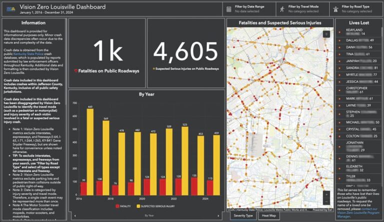
One of the first tasks Yates undertook in her new job was to create the Vision Zero Louisville Dashboard. Once a month, she pulls public data on traffic collisions and maps the locations of roadway fatalities and suspected serious injuries. She also set up news alerts for searches such as “Louisville pedestrian,” “motorcycle crash Louisville,” and “fatal crash Louisville.” She reviews these every day and catalogs them in her web browser. She then disaggregates the crash data to the individual level and, if possible, attaches any related news stories to the crash information on the map.
In the publicly available dashboard, users—including city leaders and elected officials—can click on a collision and find out more about the people involved. Yates’s goal is to show that these crash statistics aren’t just numbers; they represent real people whose lives have been altered and, in many cases, ended on Louisville’s roads.
“Humans make mistakes,” she said. “Maybe they misjudged the amount of time that they had to make a left turn. But that mistake shouldn’t be a death sentence.”

Open, Transparent GIS Data Gets Results
Three years in a row, Louisville’s Vision Zero initiative has received federal funding to support its road safety projects—in large part because of GIS analysis. This work also won Yates and the department a 2023 Special Achievement in GIS Award from Esri.
In 2022, Louisville Metro Public Works secured more than $21 million in Safe Streets and Roads for All (SS4A) grant funding to convert several four-lane roadways into three-lane roads with designated turn lanes. The grant application featured maps and analysis revealing that fatal and serious-injury crashes occurred more frequently in disadvantaged areas.
In 2023, Louisville Metro Public Works was awarded $7.5 million through SS4A to make safety improvements to a pair of one-way streets that connect downtown with the University of Louisville. And in 2024, the city was awarded a partial SS4A grant of $800,000 to hire two new staff members to support Vision Zero.
“Because GIS was central to why Louisville received this grant money, the city now makes GIS analysis a big part of its grant applications,” said Loza. He credits Yates with elevating GIS to that pivotal role and making geospatial data useful, open, and fully transparent.
“I often remind myself and my colleagues to ‘share and share alike,’” Yates said. “All of our work is owned by the community, and so therefore, the community should have access to the data and the work that they are paying for.”
Yates said that anything she would tell her boss, she’d tell the public. So she posts all her publicly available data to Louisville’s open data portal. There, the public can see that the number of people killed on surface streets in Louisville in 2024 was the lowest since 2019.
“But I do not rest on that,” Yates said. “That is still entirely too many people losing their lives.”

