Jim Alberque remembers the moment he connected the dots. It was around 4:00 a.m. and there was a blizzard coming to Boston, Massachusetts. As an employee of the city’s IT department, he was sitting in the emergency operations center behind department directors as they traded updates on the weather situation the city was facing.
At the time, Alberque was passionate about GIS work, but not equally passionate about public service—it just happened to be how he was putting his GIS acumen to good use. At the end of the blizzard-related updates, the mayor’s chief of staff said something that’s stuck with Alberque ever since: There’s a mom who’s going to wake up in 30 minutes, and she’s going to need to decide whether her kid is going to school based on road conditions. And if her kid doesn’t go to school, the mom might lose her job.

This human impact that public service has on an individual—and how GIS can help—is what stoked Alberque’s enthusiasm for being a public servant.
“That inspires me,” he said. “I feel like we’re close to the levers and buttons that affect people’s lives.”
Now the GIS and emerging technology manager for the City of Raleigh, North Carolina’s IT department, Alberque has spent 25 years in local government using GIS to help make cities better for their residents. He and his team have embraced GIS-enabled digital twin technology to generate useful data for the city, run scenarios for future planning, and tell compelling stories about the city’s data. That’s in addition to integrating GIS into operations citywide, including using ArcGIS Dashboards and data from ArcGIS GeoEvent Server and ArcGIS Living Atlas of the World for emergency response. Alberque and his team also use ArcGIS Indoors to manage facilities. The City of Raleigh received the Enterprise GIS Award during the 2024 Esri User Conference (Esri UC).
“There are very few things that technically you can’t do,” he said of GIS. Alberque added that the key is having the needed skills and curiosity to get the technology to do what you want it to do.
Passion for GIS and Public Service
Alberque grew up in central Massachusetts and moved to the Boston area in his late teens. He didn’t really know what he wanted to do with the rest of his life, and he lacked “a little bit of focus,” he said.
It wasn’t until Alberque attended Framingham State University, west of Boston, that he discovered that the science of geography came naturally to him. He graduated with a degree in the subject. Still, it took his dad introducing him to a friend at an engineering firm who was leading a new GIS department, for Alberque to find his calling.
Once hired as an intern, Alberque said he quickly realized that GIS was something that he could be passionate about and had an aptitude for, and that it made him excited to go to work every day. Ever since, his career has been punctuated by technology releases and what he could do with them, whether it was ArcView or ARC/INFO (the first release of ArcGIS); ArcIMS; or, now, ArcGIS Enterprise.
He credits the flow of his career path, and his growing use of GIS in innovative ways, to the many teams he’s worked with. First, there was the job where he learned the technical underpinnings of GIS—as a GIS analyst for Central Transportation Planning Staff in Boston’s Metropolitan Planning Office. Then there were the jobs that instilled in him a passion for public service, at Boston’s Redevelopment Authority (now the Boston Planning Agency) and the city’s IT department.
“They had a real appetite to innovate and leverage technology in new ways,” he said.
It was also during that time that he began to build a relationship with Esri as an organization, specifically with employees working on 3D modeling, to seek out help with how the city could use the tools.
“Each one of the stops in my career, I’ve been super lucky to be surrounded by smart, caring, passionate people,” he said.
He’s since brought both the aptitude and advocacy for GIS and public service to Raleigh.
Innovating in Raleigh
Alberque’s reasons for moving were not unlike those of many others moving from bigger cities to fast-growing Raleigh: He knew people who had moved there—in his case, his sister and her family. Visiting, he saw firsthand how a dollar went further for square footage compared to the cramped and historic quarters in Boston. His sister’s home was brand-new, everything worked, and “it seemed like a mansion to me,” he said. Plus, there were the good schools and the good weather.
There was also the professional challenge. Between 2010 and 2019, Raleigh gained 260,292 new residents, growing by 23 percent, according to a Carolina Demography report from the University of North Carolina at Chapel Hill.
Alberque, his wife, and their three children were among those new residents when they moved to Raleigh in 2013.
The city’s growth has continued, and Alberque believes GIS can help mitigate some growing pains.

When he arrived, he quickly realized that “Raleigh was so far ahead…from a GIS perspective,” he said. Raleigh fostered close collaboration between the city and Wake County, and the city invests heavily in data and technology. Alberque said he wouldn’t necessarily be building something new but, rather, would be trying not to break what was already there.
“We are definitely doing a lot. The key there is ‘we,’” he said. “They’re curious, they’re interested in what’s next and what’s happening,” he said of his team members, adding that they share his passion for public service.
Alberque said he also brings some competitiveness to the team. “I read ArcNews, and when I read it, I think to myself, ‘Why are they writing about them and not us?’” he mused.
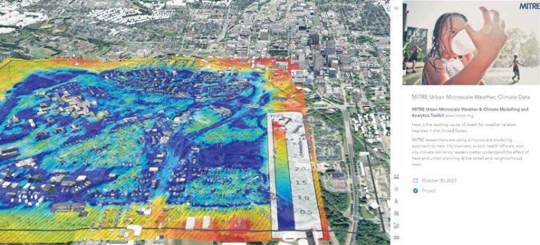
His team has set a high standard, recently garnering attention in publications such as Axios and GovTech about its work to analyze urban heat islands in Raleigh by building a digital twin. The team has been working to create a micro-scale climate model that could show wind patterns in the city related to what’s been built, exhibiting where there may be still, trapped air behind buildings that influences ground temperatures.
Alberque’s team has also been employing computer vision, using data gathered from about 200 traffic cameras and applying machine learning to detect activity that might otherwise go unnoticed. The information can help inform signal timing and design roadways.
He said he feels lucky when meeting with someone in the city who starts to ask, “‘Can you…’ And I’ll just stop them: ‘The answer is yes.’”
A World Built on Spatial Analysis
When Alberque thinks of a future driven by advancements in generative AI, he’s keen to note that much of the foundation for large language models is built on the distance and angles between related types of data. “The whole world is about to be built on spatial analysis,” he said.
He’s not about to cede his passion for public service to AI, though. He regularly parks about a half mile from the office so he can walk through Raleigh neighborhoods to get to work. He marvels at the mechanics of cities—things like arranging seamless trash pickup for hundreds of thousands of people, for example—every few days.
“That stuff is fascinating to me,” he said.
And it’s on those walks that he’s frequently thankful to work for the people of Raleigh and be part of the city’s mechanics.
“That public service thing? I take it pretty seriously,” he said.

