By the end of January, 2025 had already reportedly become the second-most destructive year for fires in California’s history. The Palisades Fire and the Eaton Fire—both of which broke out in Los Angeles County on January 7 and burned for weeks, fueled by powerful Santa Ana winds and extended drought conditions—destroyed or damaged more than 16,000 homes and other structures, according to nonprofit news organization CalMatters.
As the fires burned out of control, agencies on the ground were getting help from GIS and satellite imagery to allocate resources as effectively as possible, prioritize areas in need, and expedite relief to affected communities. In particular, Esri partner ICEYE, which operates the world’s largest synthetic aperture radar (SAR) satellite constellation, quickly delivered radar-based building-damage analysis to federal, state, and local organizations fighting the fires and providing emergency services. This allowed those organizations to understand how the fires were evolving and begin early damage assessments.
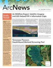
 and 3,167 of which are undamaged (shown by blue markers), following a wildfire. The image uses a 3D model and shows the structures spread across a coastal hillside.")
“With the fires in Los Angeles, there was a massive data gap. Agencies couldn’t fly because of the persistent high winds, and they couldn’t see through the smoke or as the fires burned during the night,” said Andy Read, ICEYE’s vice president of government solutions. “That’s where our technology stands out. Our satellites use radar imaging that can see through smoke, clouds, and at night. Our analysis team then delivers GIS-ready insights that help government agencies understand the damage at a structural level in near real time.”
How Radar Helps Determine Destruction
ICEYE builds its own satellites, and because it has so many in orbit, the satellites can revisit the same areas frequently. This ensures reliable data collection during and immediately after natural disasters such as wildfires, floods, and hurricanes.
Satellites that record optical imagery require sunlight, good weather, and no visual obstructions. But radar-based satellites like the ones ICEYE produces send radio waves down to Earth that bounce off objects, such as buildings and vegetation, and return pulses to the satellite. By measuring the time it takes for the pulses to return to the satellite, ICEYE can determine the locations of those objects and their distance from the satellite.
“This means that ICEYE can deliver insight day or night, through clouds and smoke, and regardless of high winds that ground the planes and drones that record traditional aerial imagery,” said Read.
For the recent fires in Los Angeles, the company deployed its Wildfire Insights service, which leverages a machine learning model to analyze rapidly acquired high-resolution imagery. The model, trained on historical wildfire events, picks up on the differences in return pulses for buildings that have been destroyed versus those that haven’t been impacted.

Actionable Datasets Ready for Analysis
The imagery that ICEYE produces isn’t delivered to its customers in a raw format. Rather, the imagery is packaged in ready-to-use geospatial datasets via Wildfire Insights, an always-on service that’s part of ICEYE’s portfolio of natural disaster analytical products. Agencies on the ground can then put these datasets directly into ArcGIS Online or ArcGIS Pro to create the geospatial products they need.
The way the service works is that at ICEYE, a team of meteorologists and geospatial and remote sensing experts continually monitor and analyze SAR imagery of wildfire events. Public safety agencies don’t have to delineate areas of interest or request imagery acquisition timelines; ICEYE just has those ready to go as actionable geospatial datasets that are compatible with ArcGIS technology.
“After we collect the images, we instantly start to analyze them and build that geospatial dataset,” Read explained. “Then we deliver it seamlessly to the customer.”
Agencies can take the datasets, plug them into whichever ArcGIS products they’re using, and create maps, dashboards, and other visualizations of the events they’re managing.
“Every one of the end users is probably doing something a little different with the datasets, whether they’re using ArcGIS Pro to do some additional analysis or building dashboards to use internally,” said Read.
During Southern California’s recent fires, federal, state, and local agencies used ICEYE’s datasets to fill in data gaps and get baseline damage assessments for impacted neighborhoods, despite the challenging conditions. For the Palisades Fire, ICEYE acquired and delivered its first image within 24 hours of the first signs of smoke on the ground. The ICEYE team continued to provide updated results of impacted buildings for that fire twice daily while also imaging and analyzing the nearby Eaton and Hurst fires—the latter of which was a smaller fire that broke out in northern Los Angeles County on January 7 as well.
One state-level organization that responded to the fires used the SAR data to quickly analyze burn scars and determine the extent and geographic distribution of impacted areas. The resultant damage assessments were then efficiently shared with local, state, and federal partners through ArcGIS Online and a dedicated collaboration hub. This streamlined approach ensured a common operational picture, enabling agencies across all levels of government to effectively coordinate resources and accelerate recovery efforts.
Getting Ahead on Damage Assessments
Being able to start on damage assessments early is one powerful use case for ICEYE’s imagery.

To conduct traditional damage assessments, public safety agency staff members typically go door-to-door gathering data about damaged and destroyed buildings. These surveys are time-consuming to perform and difficult, if not impossible, to do while wildfires are still burning in the vicinity.
In the case of the recent fires in California, high winds persisted for several days at a time, only to pick up again after brief reprieves. This impacted firefighting efforts and grounded traditional airborne assets, creating blind spots for first responders and damage assessors. Integrating ready-to-use SAR imagery datasets helped these agencies fill in some gaps while the fires still raged, significantly enhancing both speed and accuracy.
“We were able to tell the story of what happened on the ground before they could get in to do assessments,” said Read. “With Wildfire Insights, an agency’s GIS team doesn’t have to spend time analyzing the imagery to get answers. We’re delivering actionable information through our geospatial datasets. This means agencies can respond decisively as the event is unfolding.”
This is true for wildfires as well as other natural disasters such as floods and hurricanes. ICEYE’s Flood Insights solution is used extensively to provide situational awareness during flood events and heavy storms.