It is no secret that the world’s oceans are undergoing sweeping changes. The signs are apparent in shifting ocean currents, changing distributions of marine species, and anomalies in once-predictable weather patterns.
As ocean temperatures rise, marine organisms large and small are increasingly on the move. Marine megafauna—such as tunas, sharks, billfishes, marine mammals, seabirds, and sea turtles—now roam into cooler waters or alter their migrations to align with new ocean conditions.
These variations are just the beginning of a cascade of impacts that a changing climate will continue to impose on marine megafauna and marine ecosystems. As species relocate to keep pace with shifting habitats, entire food webs may be reshaped, fish populations may collapse, and the human communities that depend on these resources may find themselves grappling with unprecedented challenges.

The stakes for natural resource and conservation management in the ocean are higher than ever. Climate-driven changes amplify conflicting management objectives, such as how to ensure the sustainable use of resources while conserving marine biodiversity. Commercial fishers, for instance, may find that it’s harder to catch the most valuable species, so they fish at different times, or in different locations, or with different gear. Recently, there’s been an increase in the number of whales getting entangled in fishing gear along the Atlantic and Pacific coasts in the United States, highlighting emerging conflicts in how humans and marine megafauna interact with changing ocean environments. Protected area managers are also concerned that the species for which these areas were established will shift their habitats, limiting how effective protected areas are as refuges.
As marine ecosystems and ocean users continue to adapt to unpredictable oceanographic conditions, the future presents significant economic, ecological, and cultural challenges. Addressing these changes requires new tools and approaches to navigate an uncertain future. The Fisheries and Climate Toolkit (FaCeT) takes a dynamic approach to ocean management by bringing together various data sources and employing ArcGIS Hub to foster collaboration among disparate stakeholders.
A Toolkit for Flexible, Proactive Ocean Management
FaCeT seeks to equip fisheries, marine spatial planning specialists, and conservationists with critical tools for managing and protecting changing oceans. Researchers from San Diego State University (SDSU) and Woods Hole Oceanographic Institution—with support from the National Aeronautics and Space Administration’s (NASA) Ecological Conservation program—built FaCeT to help resource and conservation managers, policymakers, and communities adapt to changes taking place in the ocean.
FaCeT does this by integrating multiple streams of information, including satellite-based data and ocean climate models that capture important oceanographic variables, such as historical, present, and future sea surface temperatures and chlorophyll concentrations. Other information streams include various fishery-independent and fishery-dependent biological data, as well as ecological forecasting tools that predict changing species distributions. Together, the teams use these data streams to develop a wide range of products designed to support climate readiness and ocean resilience across multiple ocean management sectors.
At the heart of FaCeT’s approach is the idea that ocean management must be dynamic and flexible to respond to changing ocean conditions. Dynamic ocean management encourages developing proactive frameworks that allow practitioners to adjust their actions so they reflect changing ocean conditions across timescales, from near real time to the end of the century.
When warm-water predators move into regions where they were previously rare, for example, local managers using dynamic ocean management approaches can respond swiftly by changing allowable catch levels, modifying what gear can be used to reduce bycatch, or shifting fishing operations to areas more likely to yield high catch counts. To continue conserving protected species, local managers can make dynamic changes to what activities are permitted in certain areas. This is climate-informed management.
Harnessing Cutting-Edge Data and Technology
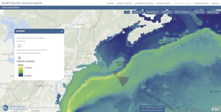
The data integration that FaCeT provides facilitates the agility and flexibility that dynamic management requires. Remotely sensed data—including from NASA satellites—delivers updated snapshots of ocean conditions, while forecast models project how factors such as temperature, salinity, and primary productivity will change over weeks, seasons, and decades. By overlaying this environmental data with dynamic species distribution models—and then identifying both current and future hot spots for marine megafauna—FaCeT helps managers and stakeholders see what will likely change in the ocean over the next season, decade, and century.

Esri products are instrumental to FaCeT’s ability to harness data and technology. Using a site made with ArcGIS Hub, SDSU and Woods Hole researchers are working with partners such as the Northeast Regional Ocean Council to develop state-of-the-art tools, including the Northeast Ocean Data Portal. These tools serve data visualizations, projections, models, and maps to resource managers and users.
These data-driven products are made in direct collaboration with users. While the science and technology behind FaCeT can seem complex, the research team has prioritized the development of accessible and needs-based products. For example, FaCeT provides visualizations of how key Northwest Atlantic species distributions are projected to change in upcoming decades. Rather than releasing jargon-filled technical reports, the FaCeT team creates interactive dashboards based on in-depth surveys and collaborations with users, bridging the gap between research and management.
With accessible maps, figures, and charts, FaCeT supports data-driven, climate-smart applications. The result is a toolkit that can transform raw data into knowledge and, ultimately, action.
Science Must Inform Practice
As the FaCeT initiative illustrates, building a climate-resilient future for marine ecosystems is possible. By using cutting-edge Esri technology, robust data streams, and accessible data visualizations, FaCeT offers a model for how science can inform practice.
Although no single toolkit can solve all the problems arising from climate change, FaCeT’s integrative and adaptive approach represents an essential step toward proactively governing the world’s oceans. This approach acknowledges the ever-changing nature of the oceans and the communities that depend on them.
As climate change pushes species to new frontiers, and as once-predictable patterns give way to novel conditions, the pressing task is to ensure that resource and conservation management keep pace. Nimble tools like FaCeT will help communities cope with today’s challenges and anticipate tomorrow’s opportunities, encouraging a shift from reactive measures and rigid management structures to proactive strategies and flexible, resilient frameworks.
The future of the world’s oceans hinges on humans’ capacity to think creatively, collaborate widely, and make decisions informed by sound science. By learning from initiatives like FaCeT, and the researchers and communities that shape them, people can better navigate the turbulent waters that lie ahead. The alternative—watching as marine ecosystems falter under the strain of warming ocean temperatures and changing weather patterns—is not an option for a society that relies on oceans for food, livelihoods, and biodiversity. Instead, the path forward requires harnessing the best-available knowledge; embracing adaptive strategies; and forging partnerships that span disciplines, sectors, and borders.
Oceanic and societal resilience will depend on people’s collective ability to read the changing signals, respond flexibly, and work together to help create a more sustainable future.


