This regular column contains information about the latest updates to ArcGIS Online, including new features and capabilities, basemap updates, and content contributed by the global user community through the Community Maps Program. This issue focuses on the July release of ArcGIS Online, which was a major update and includes new capabilities for online analysis, enterprise logins, and a newly designed look and feel.

Map Viewer
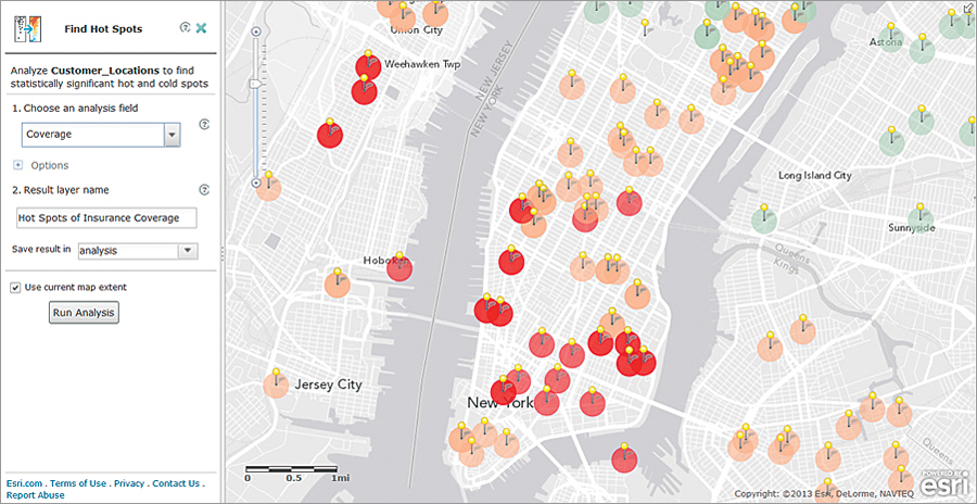
The online spatial analysis tools that were previously in beta have been fully released and can be accessed directly in the map viewer. The tools are organized into functional categories: Summarize Data, Find Locations, Data Enrichment, Analyze Patters, Use Proximity, and Manage Data. Using these analysis tools will consume service credits, and we’ve included a Show Credits tool so you can calculate the credit usage before starting your analysis.
We’ve improved Directions and Routing so that now you can add a location directly from a pop-up window. Once you’ve calculated a route, you can save the route and associated locations as a layer so you can view it later on or perform additional analyses, such as Create Buffers or Find Nearest.
Image service layers have been improved to provide a better default display. Map authors can configure the display, show tables, create filters, display or hide legends (ArcGIS 10.2 for Server services), and configure pop-up windows.
To get better results when you search for an address or place, the map viewer now displays the best result based on the input location or address. It also offers an option (“Not what you wanted?”) where you can choose similar locations. For maps that you embed, you can restrict finding addresses or places within the extent of the map. This is useful for applications where you want to enable searches only within a particular area, such as a city or state.
The symbol gallery has been expanded and now includes a new collection of A to Z symbols available in three colors.
Web Applications
The CityEngine web viewer has been enhanced with streamlined map user interface controls, a full-screen button, and better shadow control resolution with cascaded shadow maps.
The very popular Map Tour story map template can now be used by public and organizational account users. You can import pictures from several popular online photo sharing services (Flickr, Facebook, and Picasa), from other hosted locations via a URL, or through a CSV file.
There is also a new Swipe story map template. Configurable and designed to work in browsers and on mobile devices, it allows you to display two web maps or two layers in the same web map in a window split vertically, or you can use the spyglass option to focus on a specific area.
The existing Swipe template has been deprecated, and the code will no longer be updated. The template was available in the web app template gallery and has been replaced with the new Swipe story map template. Existing applications that are using the deprecated Swipe template will continue to work. If you’d like to continue using the old Swipe template, you can download it from ArcGIS Online and host it on your own web server.
ArcGIS Apps
Esri Maps for Office was updated to include statistical hot spot/cold spot analysis, access to additional data for data enrichment and the ability to select individual data variables, new infographics options, new authentication options, and support for Portal for ArcGIS.
Esri Maps for SharePoint is now one of the apps that are included with the ArcGIS Online subscription. When you purchase a subscription or sign up for a free trial, you can download this app, along with three other apps that are also included in the subscription: Operations Dashboard for ArcGIS, Collector for ArcGIS, and Esri Maps for Office.
ArcGIS for Windows Phone now includes support for Windows Phone 8 and two new languages, Danish and Portuguese (Portugal).
Ready-to-Use Tools and Layers
Geocoding has been improved for more than 15 countries, including Malaysia and Turkey. Routing is now available for South Korea and 41 other new countries, for a total coverage of 144 countries.
Esri Data and Maps for ArcGIS layers have been updated with recent datasets. You can access these layers through the Esri Data and Maps group in ArcGIS Online.
ArcGIS Online Account Administration
Administrators now have the ability to invite users with enterprise login accounts to the ArcGIS Online organization. Users do not need to create additional logins within ArcGIS Online. They can use the logins that have already been set up within their enterprise system. This capability was previously in beta.
The Status page has been updated to include newly added services, such as spatial analysis, and more accurately reflects the usage of services and service credits. The Status page has been divided into four sections: Storage, Analytics—Usage, Premium Content—Usage, and Published Content.
Usability and Design Improvements
The ArcGIS Online website has been updated to improve usability based on user feedback and testing and also features a fresh design. For example, under My Content, you can now filter the content to display just web maps or just layers of a specific type, for instance, feature layers. One-click actions Add to Map and Add to New Map have also been added. The map viewer navigation has been enhanced with a new Home menu so you can more easily navigate to other areas of the site. You can also now sign in to your public or organizational ArcGIS Online account from arcgis.com home and feature pages or go directly to your organization’s site to sign in.
ArcGIS Online Basemap Updates
- World Topographic Map—Since the last ArcGIS Online release in March, this very popular basemap has been updated with lots of content from users around world. These contributions were made through the Community Maps Program and include updated or expanded content for the following countries at 1:288,000 to 1:1,000 scale: Finland, Jordan, Saudi Arabia, and Morocco; at 1:577,000 to 1:1,000 scale for Romania and Slovakia; and at 1:144,000 to 1:1,000 scale for Singapore. Content was also added for Hong Kong (1:577,000 to 1:1,000) and Macau (1:144,000 to 1:1,000). We also received contributions for several counties and cities/towns at 1:9,000 to 1:1,000 scale. The following are just a few examples: counties—Bernalillo County, New Mexico; Douglas County, Nebraska; Florence County, South Carolina; Orange County, Florida; Wahkiakum and Yakima Counties, Washington; and Yavapai County, Arizona; cities/towns—Bellevue, Olympia, and Spokane, Washington; Carson, California; Keller and Longview, Texas; Lexington, Massachusetts; Town of York, Maine; Westminster, Colorado; Wichita, Kansas; Canmore, Cochrane, and St. Albert, Alberta, Canada; and Prince George and Squamish, British Columbia, Canada.
- Three Educational Institutions Contributed Their Campus-Level Data—California University of Pennsylvania; Kutztown University, Pennsylvania; and Loma Linda University, California, all at 1:9,000 to 1:1,000 scale.
- World Imagery Map—New high-resolution imagery from DigitalGlobe for many places worldwide has been added to the World Imagery Map over the past several months. This includes imagery for At Ta’if, Saudi Arabia; Belfast, Northern Ireland; Chiclayo, Peru; Diyarbakir, Turkey; Edinburgh, Scotland; Hiroshima and Tokyo, Japan; Innsbruck, Austria; London, England; Perugia, Italy; Saint-Malo, France; Seoul, South Korea; Sucre, Bolivia; and Wroclaw, Poland. We also added contributions we received through the Community Maps Program for Cochrane, Alberta, Canada, and Olesnica, Poland, as well as several cities in the United States.
- World Street Map—This map now includes large-scale coverage for all major cities in the Americas, including Buenos Aires, Argentina; La Paz, Bolivia; Montevideo, Uruguay; Panama City, Panama; and San José, Costa Rica. For Rio de Janeiro, Brazil, we’ve also increased the quantity and accuracy for building footprints and associated features, like parks, walkways, and pools. We also included additional coverage for the Middle East and North Africa for the following countries: Bahrain, Egypt, Israel, Kuwait, Lebanon, Oman, Qatar, Saudi Arabia, and the United Arab Emirates.
For a complete list of all contributions to each of the world maps, visit esriurl.com/contributors.
If your organization doesn’t have an ArcGIS Online subscription yet, sign up for a free 30-day trial. You can invite up to five named users to participate in the trial, and you get 200 service credits and these productivity apps as part of your trial: Collector for ArcGIS, Operations Dashboard for ArcGIS, Esri Maps for Office, and Esri Maps for SharePoint. Once your trial is over, purchase a subscription and continue to use all the features and services in the same ArcGIS Online subscription account. To sign up for the trial, go to esri.com/agoleval.
See also “Get More with ArcGIS Online.”

