The goal of the European Union (EU) Open Data Directive has been to put more public data—location based or otherwise—into the reach of those who can use it, especially datasets considered to be particularly beneficial to society. These include geospatial, meteorological, earth-observation, and environment datasets.
According to the European Commission’s EUR-Lex website, the directive is based on the principle that public and publicly funded data should be reusable for commercial and noncommercial purposes. Potential socioeconomic benefits include more affordable public services, more sustainable public transportation, improved carbon-reduction efforts, and better ways of reacting to climate emergencies.

The directive is a legal framework for public data reuse and is part of the European Commission’s larger data strategy. The regulation implementing this data strategy includes a list of high-value datasets to be shared under the directive by June 2024. In addition to being made available for free to anyone who wants them, high-value datasets must be presented in a machine-readable format via APIs and bulk downloads. ArcGIS products such as ArcGIS Hub, ArcGIS Online, and ArcGIS Enterprise help deliver this beneficial data for friendly reuse.
A Geographic Approach to Open Data
Ultimately, making open data available to leaders, decision-makers, knowledge workers, students, researchers, innovators, and the public means that more of Europe’s brightest minds will be able to apply a geographic approach to problem-solving and developing innovations, including those related to AI. This includes location data, which helps reveal patterns and trends; model scenarios and solutions; and ultimately helps people make sound, strategic decisions as they address often complex issues.
“We want to make as much government data as possible findable and accessible, including clear information about the quality,” Jelle Verburg, former product owner of data.overheid.nl, told Esri Netherlands in 2019. ArcGIS helped optimize the ability to find geospatial open data on the site, which is the data register of the Dutch government. “Our portal is a kind of telephone book you can browse through, looking for the dataset you need,” Verburg said.
Many local and national EU governments already use ArcGIS to deliver open data, including the following:
- The Assen GeoHub in the Netherlands, supports the City of Assen’s goals for transparent, reliable, and easily auditable government.
- In the Czech Republic, the City of Brno (see article on page 22) shares standards-based open data at its hub site. In the city of Prague, leaders are using open data such as satellite earth observations to better understand relationships between human health and the built environment and help guide efforts to cool the city with green space.
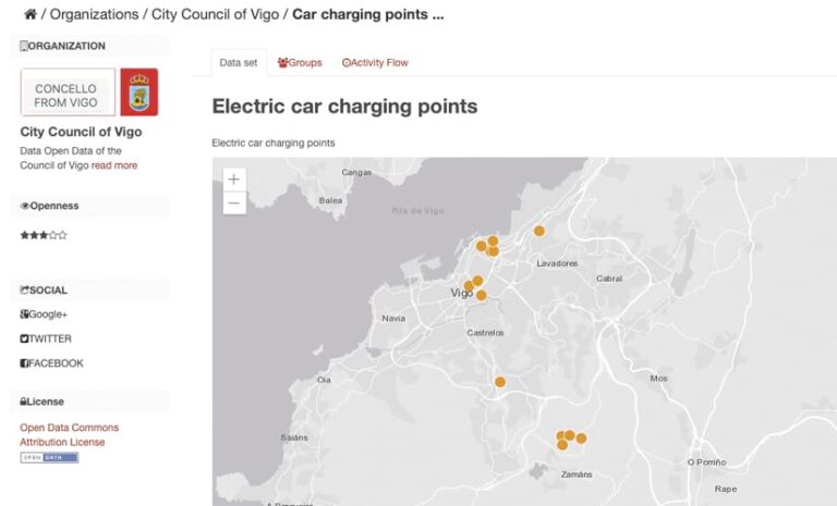
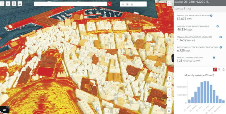
- In Spain, the Vigo city council shares 2D and 3D open data in its Portal de Mapas for sustainability analyses such as the potential energy produced by solar panel arrays at specific locations.
- In Ireland, the national geospatial open data hub GeoHive provides free, web-based access to up-to-date Irish spatial data to meet the needs of citizens, businesses, and government.
ArcGIS Supports Open Data
ArcGIS Hub, ArcGIS Online, and ArcGIS Enterprise are helping implement the Directive by helping users meet requirements such as open formats, enabling data reuse by electronic means, supporting online search and discovery, and making dynamic data available via an API and bulk download. International open standards and specifications, including GeoServices REST, Open Geospatial Consortium (OGC) API features, SpatioTemporal Asset Catalogs, and OGC GeoPackage, are supported.

Ensuring that demand for reusable open data can be met, ArcGIS Online supports scalable web services. End users can quickly put data layers to use or use them in applications created using low-code application builders.
Metadata in ArcGIS follows international standards, including ISO standards and Infrastructure for Spatial Information in Europe (INSPIRE) Directive formats. The ArcGIS system helps ensure that spatial datasets are available according to findable, accessible, interoperable, and reusable (FAIR) data principles.
ArcGIS Online also includes the free ArcGIS Hub extension’s open data capabilities. This allows ArcGIS Online users to provide open geospatial data; maps; apps; and nonspatial data such as documents, images, spreadsheets, tables, and PDFs to residents, students, journalists, business innovators, civic developers, and others. ArcGIS Hub also makes it easier for site visitors to find the data they’re looking for by searching an online open data catalog. Hub automates many search engine optimization techniques and web content accessibility guidelines.
Automated catalog feeds use international open standards such as GeoRSS, OGC API – Records, and DCAT Application Profile for Data Portals in Europe (DCAT-AP) to allow sharing with open data portals such as data.europa.eu. Hub also supports multilingual capabilities with automatic translations and license generation for Creative Commons public domain dedication or other less restrictive standard public licenses.
Ensuring the Reuse of Open Data
By supporting the EU Open Data Directive, ArcGIS helps organizations make their data available for friendly reuse so that it can then be used to gain insights for decision-making or to develop innovations. As Esri co-founder and president Jack Dangermond said in a 2021 company statement commending the EU’s efforts, the directive “empowers European users to find solutions and enact data-driven policy to address challenges, from local to global.”

