Leaders in Roanoke County, Virginia, developed a way to give staff and citizens easy access to information about local government using a geographic framework.
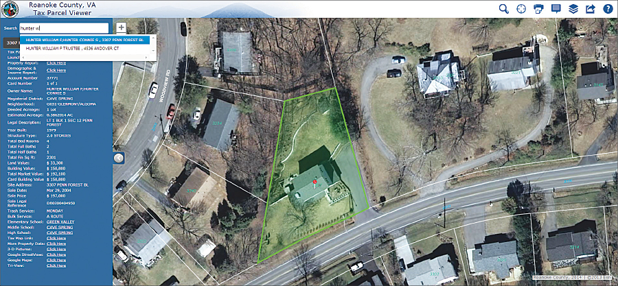
County GIS manager David Wray suggested replacing the existing ArcIMS site with one built using ArcGIS for Server and the ArcGIS for Local Government app templates. The new GIS Maps and Apps Gallery provides one place where citizens and staff can find tax, government services, and election information. It hosts TaxView built with the Tax Parcel Viewer template, GovView using the My Government Services template, and VoterView adapted from the Election Polling Places template. These three apps can be used on a PC, mobile phone, or tablet.

“We wanted to build platform and device agnostic apps so they work regardless of which mobile devices or browsers someone uses. We want apps that everyone can access—this platform helps us do that,” said Bill Hunter, Roanoke County director of communications and information technology.
Esri partner GISi customized the search to include autocomplete for addresses, parcels, and points of interest. Start typing “Jones,” for example, and by the time you’ve typed in “jone” a list of possible matches appears. GISi also created an accordion view of information to allow menus to expand and collapse.
The data for these apps is in the ArcGIS for Local Government Information Model. “Putting our data into the model gives us the flexibility to develop apps we need when a business case arises,” said Wray.
In GovView, citizens can see a personalized view of their government services. A search by name or address produces information on trash pickup day; nearby recycling facilities; and neighborhood recreation facilities, libraries, and police stations.
TaxView provides a wealth of property information. Residents and real estate agents can see deeded acreage, values, sales dates, assigned schools, and much more. They can also access a customized interactive property report and an Esri GeoEnrichment demographic and income report.
VoterView shows polling locations and hours as well as the current elected officials for local, state, and federal districts. “With GovView, TaxView, and VoterView, we tried to break out common, easy-to-use functions for casual users while maintaining OneView, a comprehensive solution for GIS power users, for staff,” noted Gray Craig, web content manager for Roanoke County.
GISi developed OneView as a more comprehensive solution that offers a breadth of functionality in one application. OneView was configured to consume the same data sources and services that are delivered through other applications, creating a consistent and efficient overall solution. Its flexible interface lets staff and citizens explore a wide variety of data through more advanced visualization controls and query tools. The data includes real estate sales, land records, planning and zoning, schools, government services, and environmental and utilities information.
“The templates give you a jump start on building apps, so if you have a small budget and no developers in-house, you can take these apps and deploy them to share your content,” said Wray.
For more information, contact David Wray, GIS manager, Roanoke County.

