Affordable housing is a pressing issue across the United States. According to the US House of Representatives’ Committee on Financial Services, there’s a nationwide shortage of nearly 14 million rental housing units for rent and purchase. Housing costs in New Jersey are among the country’s highest, which particularly affects low-income households. However, various federal laws require local governments to provide opportunities for affordable housing.
Located between New York City and Philadelphia, New Jersey’s Somerset County has around 350,000 residents, according to the 2020 US census. Somerset County was New Jersey’s second-most affluent county in 2022, based on median household income reported by the census, with high housing costs to match. The January 2024 median home value was nearly $570,000, according to Realtor.com, with home values and rental costs that had jumped during the COVID-19 pandemic.
The county’s Office of Planning, Policy, and Economic Development provides guidance to officials related to housing and demographics, including affordable housing. The office collaborates closely with the county’s 21 municipalities to ensure that affordable housing options are available for residents, including seniors, and it has a comprehensive list of affordable and senior housing developments. However, until recently this data was not available in an easy-to-use, user-friendly format, and it was largely underutilized.
To raise awareness about the county’s housing options, the Somerset County Office of GIS Services developed and deployed the Somerset County Housing Navigator website using ArcGIS Experience Builder, a configurable solution for building web applications that is included in ArcGIS Online and ArcGIS Enterprise. This interactive and mobile-friendly site offers details on available housing options and allows users to perform searches and filter them based on preferences and needs. The website has gained popularity among residents and enhanced the county’s capacity to provide essential data to people who are seeking a home.

Improving Data Availability
Previously, the county’s housing data for affordable and senior housing was presented to the public in static PDF maps and extensive spreadsheets. These formats had three limitations. First, they were not interactive. Users could not actively engage with the data, such as clicking on a property for more information. Second, the PDFs’ static nature and the spreadsheets’ length made it hard for users to navigate and access the information efficiently. Third, the data was not optimized for mobile devices, limiting its accessibility.
“Our main priority is to ensure that our residents can easily access and benefit from this valuable information,” said Somerset County Office of GIS Services manager Aarthy Sabesan. “Our residents are notably tech savvy, and we wanted to create a product that meets their evolving needs.”
Sabesan and her team focused on crafting an engaging user experience (UX), including a mobile-friendly design. The goal was a design that would let users find information or complete a task in about three clicks. Using housing datasets that were updated in advance, developing the website took just five weeks.
“I was able to conceptualize and launch the application in about half the time I initially expected,” said Sabesan. “The design flexibility played a significant role in that.”
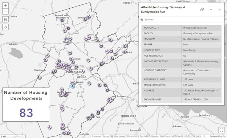
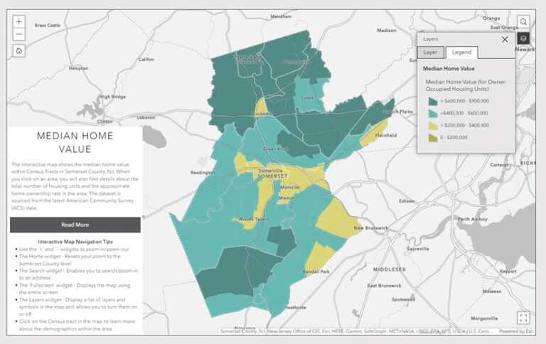
The new site features a comprehensive community profile with key demographic information such as age, education, employment, income, and housing. It also offers color-coded interactive maps showing median home values and a map with average rental prices. This information empowers users to make housing choices that align with their preferences and financial considerations.

The site’s housing data section has three categories: affordable housing, senior housing, and market-rate rentals. The web pages for affordable and senior housing are integrated with interactive dashboards, enabling detailed exploration of housing options. The interactive housing maps provide an overview of available housing options, including property details and contact information. Users can filter the data according to their preferences, and the results can also be exported and printed. The sections also feature a consolidated list of housing assistance agencies and their contact information.
If users are unable to find the information they need, they can complete a form that is sent to the GIS team for routing to the appropriate housing agency. The form was built using ArcGIS Survey123, which is included in ArcGIS Online and ArcGIS Enterprise.
A Successful Launch
After going live in March 2023, the Somerset County Housing Navigator website now averages about 200 views per week. The GIS team plans to update the data every six months to ensure accuracy. This was the first site launch from the GIS team, and Sabesan said they met their goal of creating a site that’s usercentric, interactive, and meaningful. “This eases the stress of finding a suitable, safe place to live,” said Sabesan.
Sabesan said Experience Builder is a user-friendly and straightforward solution that allowed her team to create a simple and intuitive interface. “It gives us the freedom to make decisions as to how we want the information and the data to flow. That ability is crucial,” said Sabesan. “You don’t have to be an experienced UX designer or software engineer to create informative and visually stunning products.” She added, “It doesn’t just look like a GIS application. It looks like a website with GIS capabilities.”
Feedback from management and others at Somerset County has been positive, Sabesan said. GIS team members are using Experience Builder to build other applications, and there have even been requests for nonspatial apps from other county departments.
According to Sabesan, “Experience Builder proved to be a versatile and highly adaptable product. With it, we crafted an intuitive and visually appealing website, ultimately delivering an outstanding digital experience for our residents.”

