Microsoft SharePoint helps organizations all over the world—from government entities to oil companies and retailers—organize their teams, workflows, and data. But native search within SharePoint is heavily reliant on text, so finding a particular file can be frustrating, especially when there is a large amount of data to wade through.
That is why Esri developed a new capability in ArcGIS Maps for SharePoint that lets users map and search SharePoint content more easily. Called ArcGIS Map Search, the app part allows ArcGIS Online and ArcGIS Enterprise users to drag files hosted in SharePoint onto a map to geotag them for easy search later. Now, when an oil company has an emergency at one of its oil wells, for example, employees responding to the incident can open up a map of all the wells in ArcGIS Maps for SharePoint; click on the one where the accident occurred; and immediately find all the documents related to that well, including permits and safety records.

Users have been requesting this tag-and-search capability more frequently in recent years, and it is now available in ArcGIS Maps for SharePoint 5.0—one of the most significant releases since the first version came out in 2010. ArcGIS Map Search, accessible in 30 languages, is supported in Microsoft SharePoint 2010, 2013, 2016, and SharePoint Online.
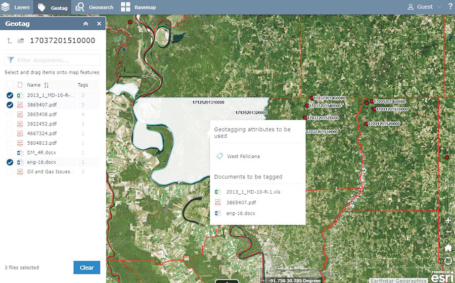
The app part contains two main components: geotag and geosearch. The process starts at geotagging. Users can add a reference layer to an ArcGIS Map Search map and specify which attribute from the layer’s data to use for geotagging. When users drag documents onto the configured layer, the attribute generates a geospatial tag, or geotag, for those documents. System administrators can configure systemwide tags as well, which ensures that tagging is uniform across the organization.
Then, when someone needs to look for the data related to a specific location, he or she can open the SharePoint page with the ArcGIS Map Search map, and it will start in geosearch mode. By clicking or tapping a point, line, or polygon on the map, the user can view all the documents that have been tagged with that feature. He or she can also type keywords into the search bar to see the list of documents tagged with those specific location attributes.
This new capability builds on the existing features of ArcGIS Maps for SharePoint that already give users the ability to map and visualize their data in Microsoft SharePoint. With the ArcGIS Maps Locate workflow, for instance, users can view SharePoint lists—such as ones with customer names and addresses on them—on a map, and the map stays current even as new data is added. Additionally, the ArcGIS Maps web part allows users to design maps with their data—and add geographic content from ArcGIS—so they can better visualize their business information on SharePoint site pages.
The latest release of ArcGIS Maps for SharePoint elevates what users can do when they work with ArcGIS and SharePoint together. When organizations can see and arrange their SharePoint data on a map, they save time and energy in their work and, ultimately, make better business decisions.
The on-premises version of ArcGIS Maps for SharePoint 5.0 is available here, while the online version can be downloaded from the Microsoft App Store.

