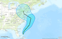
Redlands, California—Esri announces that Wall Street Network (WSN) has released the first of a dozen risk management solutions, based on ArcGIS Online, called XtremeGIS. XtremeGIS provides access to information including global tropical cyclone event and forecast data from AccuWeather, satellite imagery from i-cubed, and WSN’s knowledge management software. It can be used to discover and analyze hazards located around assets such as office buildings, retail and manufacturing sites, distribution centers, and the supply chain.
"The bottom line is you don’t have to be a meteorologist to understand a hazard or a rocket scientist to understand property risk," says Kristina Mazelis, chief operating officer at WSN. "We do the science and analytics assessing risk and provide access to it through ArcGIS Online, giving everyone the opportunity to assess their own risk."
The solutions provide users with insight into the full life cycle of risk, from mitigation before an event occurs, during the actual event, and managing the aftermath. The first three available now are the following:
- Xtreme Tropical Cyclone—Historical data and real-time storm tracking capabilities just in time for the beginning of the 2013 cyclone season
- Xtreme Proximity—Allows users to look up perils, such as flood zones, history of high-frequency windstorms, terror risks, and more, that are located next to their business assets
- Xtreme Hazard Event Provider (HEP)—A hazard event notification system that alerts users to events that occur in areas they specify
Traditionally, risk management is an expensive process and understood by only a few in an organization who have a high level of knowledge about risk modeling. These subscription-based solutions deliver content through ArcGIS Online so users can do the following:
- Create maps
- Add additional layers of information such as maps of offices, service territories, and customers
- Use the information in other desktop applications including ArcGIS
- Share maps with others via the Internet and mobile devices
"This is a real game changing, disruptive technology," says Simon Thompson, director of commercial industry, Esri. "Currently, when a catastrophic event occurs, everything shuts down. XtremeGIS gives businesses the advantage of insight so they can take control of their own activities and rethink where and how they grow."
To learn more about the XtremeGIS solutions, visit www.xtremegis.com. For more information on how the ArcGIS platform helps organizations around the world manage risk, visit esri.com/insurance.

