The second-most populous city in the state of Arizona, Tucson is a combination of old and new. Archaeologists estimate that Tucson’s downtown area has been continuously occupied for at least 4,500 years, and the city is now a busy metropolis that has attracted cutting-edge technology companies.
Tucson is also the hub of a fast-growing region. The government of Pima County, which comprises all of the Tucson metropolitan area and the sparsely populated high-desert expanses around it, expects the county’s population to grow from about 1 million in 2020 to approximately 1.3 million by 2035. This projected growth has prompted Tucson officials to develop a new and interactive approach to an old problem: how to get around the city efficiently in a variety of ways.

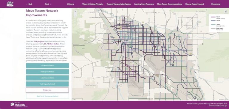
To tackle this issue, Tucson’s Department of Transportation & Mobility, with support from other city departments, developed Move Tucson, a comprehensive plan that aims to modernize the city’s transportation network. In collaboration with construction and engineering company Alta Planning + Design, city staff also used ArcGIS Online and ArcGIS Experience Builder to develop a fully digital, interactive version of the plan. The app allows the public to interactively explore how this plan will change their community and understand the investments into community mobility that city staff are seeking to make. This application is part of the transportation department’s efforts to make its plans more accessible.
A Plan to Develop Safe and Varied Transportation Options
Published in 2021, Move Tucson describes the current state of the city’s transportation system and how it is envisioned to change over time to meet the needs of both residents and visitors.
The plan identifies 234 projects and the potential funding needed to implement them over the next 20 years. Using what city staff call “Complete Streets” design—an approach to transportation planning that emphasizes a safe, connected, and equitable transportation network for everyone—Move Tucson aims to make roadways safe to use for different modes of transportation. It integrates planning for walking, cycling, public transit, and private motor vehicles.
City staff, elected officials, and the public use Move Tucson to gain insight into how the Tucson transportation system will likely develop in the coming years. The plan also explains the factors and considerations that were used to create it.
An Interactive Approach to Engaging with Content
The interactive component of the Move Tucson transportation plan offers an immersive experience that paints a vivid picture of the plan’s vision and its projected impact on the city.
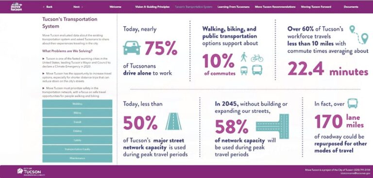
With maps, charts, photos, infographics, and other media, users can dynamically explore the plan’s content. This includes the project’s guiding principles, public engagement activities, recommendations for improvements to make, and implementation strategies.
The Transportation System tab allows site visitors to understand the transportation system in more detail. For example, roadway capacity metrics help depict the local driving experience. Transit is measured by average weekly ridership. Walking and biking are visualized using indexes called the Pedestrian Level of Traffic Stress and the Bicycle Level of Traffic Stress, respectively.

Mode-specific analysis can help a person understand not only that there are a variety of travel conditions for each mode across the city, but also that the experience can vary by mode on a given roadway. For example, a roadway may have good travel conditions for drivers and transit users because the number of motor vehicles is low, meaning the roadway is below capacity and there is ample transit service. The roadway may also have wide sidewalks and street trees, making it a good place to walk, but it might be highly stressful for bicycling because of high automobile speed limits and a lack of bike lanes. If the roadway has excess capacity and is seen as being a priority for bicyclists, bike lane installation may be deemed viable by city staff in order to improve biking conditions without hindering other transportation modes.
This nuanced understanding of the transportation system helps build a picture of how all modes of transportation are interconnected. The app for making this information accessible to the public increases transparency in the planning process while also serving as a tool that can be used for other purposes.
A Robust, Flexible App Boosts Engagement
City staff and the team at Alta Planning + Design selected ArcGIS Online as the foundation for this interactive website so that the city could host and maintain the site from now on. They chose Experience Builder to deliver the content because of its robust capabilities and ability to natively host both spatial data and media such as plan documents, images, tables, and narrative text.
“[Experience Builder] also provides greater transparency in the planning process and allows the public better access to information about the transportation plan,” explained Kim Voros, GIS manager at Alta Planning + Design.
Voros and the company’s civic analytics team worked with city staff to develop the app when the transportation plan was nearly complete. Tucson staff requested it because they had seen in other projects how interactive web maps and related media made it easier for wide and varied internal and external audiences to understand information.
“Overall, the development of the Move Tucson virtual plan illustrates the city’s commitment to continuous improvement and engagement,” Voros said. “It reinforces the use of digital planning documents as a valuable tool in shaping the future of Tucson’s urban environment.”

