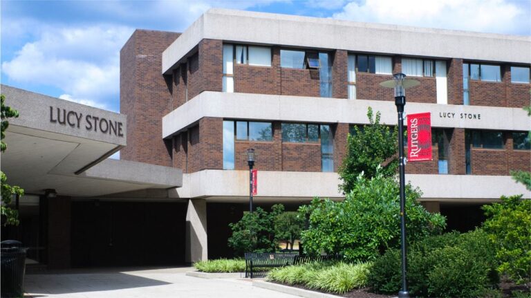
At Rutgers University in New Jersey, Lucy Stone Hall has confounded students for decades.
“If you want to find a classroom on the first floor, you have to make sure you get to the entrance right next to that classroom, or else you’ll be in another section of the building,” said alumnus Noam Aharon, noting just one of the building’s mystifying features. “You can’t actually get where you want to go unless you walk outside and find the right entrance.”
With its odd room numbering, disconnected floors and hallways, and entrances that don’t always lead to expected destinations, the long, L-shaped building needed a modern indoor map.
Either ironically or fortuitously, Lucy Stone Hall houses Rutgers’s geography department. That’s where Aharon, a geography major in the School of Arts and Sciences at the time, and Rutgers cartography instructor Michael Siegel teamed up to make sense of the baffling building by mapping it.
A longtime map enthusiast, Aharon had taken Siegel’s classes as part of the undergraduate geography program and proved to be an outstanding student. Siegel saw an opportunity for Aharon to gain practical experience through a special project: mapping the interior of Lucy Stone Hall using ArcGIS Indoors.
“He could make a potentially valuable contribution by showing decision-makers this new technology that could make life easier for thousands of people at the university every day. And for me and for the school, it might be the first step towards creating a prototype that could show what might be done with indoor GIS,” Siegel said.
Building a Better Indoor Map
Rutgers offers digital maps to help students find buildings on its campuses, but those maps don’t take students inside the buildings. In Lucy Stone Hall, printed maps posted on the walls, as well as floor plans, haven’t always made it clear exactly how to get where people need to go. Plus, it was easy for students to walk past those postings.
The building’s layout wasn’t a challenge just for students. Staff were also frustrated when class was disrupted by disoriented students who arrived late or stopped at open doorways to ask for directions. Siegel wondered if he and Aharon could use the university’s existing floor plans to extend wayfinding indoors.
Aharon had a light class load for his final semester at Rutgers, so when Seigel approached him about the mapping project, he was eager to get to work.
“I think we both learned that that was something that goes much deeper than we originally thought,” said Aharon. He believes a lot of effort has already been placed into small-scale mapping of building footprints and larger geographic areas, and that it is now time to shift focus toward high-precision, large-scale mapping of indoor spaces. “This more detailed and novel approach to mapping is what got me excited about the project,” he added.
In January 2023, Aharon began by working with Rutgers’s institutional planning and operations (IPO) team to access computer-aided design (CAD) files of the building’s floor plans to import into Esri’s ArcGIS Pro software. Rutgers students have access to both ArcGIS Online and ArcGIS Pro through the university, and Esri provided limited access to ArcGIS Indoors software for creating the indoor maps.
Aharon, who had never worked with CAD files before, taught himself about the format and how to make any needed updates or corrections. He then reviewed the files to ensure that all the details, such as shapes and lines, were fully drawn with no gaps or extra lines at the connecting points. Although the visual information the plans represented was correct, any small errors in the drawings could affect the upload into ArcGIS Pro.
Once the data was clean, Aharon used ArcGIS Indoors to create a layer for the building’s footprint, as well as layers for the first and second levels of the building, where classrooms were located. He added details for the rooms, hallways, doors, entrances, stairwells, elevators, and spaces and color-coded them for easy visual identification.
Using the ArcGIS Indoors model, Aharon was able to toggle between the first and second floors and have the map’s floor plan change. It was an important first step for his indoor map: gaining the ability to access both floors as well as search for a specific classroom.
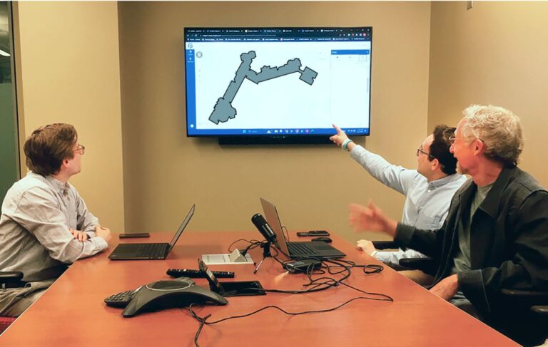
Once that was in place, origins and destinations within the building were marked. The last step was adding a network of routes within a web application hosted in ArcGIS Online to connect the various rooms of the building, allowing map users to create specific pathways from one location to another. When the network was added to the floor plans in the GIS software, the 3D map performed exactly as Aharon had hoped by providing turn-by-turn directions when searching for a path to a specific location.
“It actually told you: Go outside, go to another entrance of the building, walk along the perimeter of the building, go up the stairs here, and then go to your classroom. And then I knew, OK, it’s possible to actually create routes within this building that make sense,” he said.
Proof of Concept
Aharon presented his work to the IPO team in May 2023. His presentation included a detailed map of the first and second floors of Lucy Stone Hall, accessed through the web application hosted in ArcGIS Online, as well as a demonstration of the wayfinding feature. Aharon also provided IPO team members with documentation and data from the project as a starting point for possible future indoor GIS projects across campus.
Siegel is excited for his protégé and proud of Aharon’s achievements. “I think being able to step out of the classroom, like this project allowed him to do, was very exciting for him because he really loves that applied aspect of it. And all the pieces came together for him: the help from the IPO team, the software, and Noam using his own intelligence and motivations to find ways to make it work.”
Aharon, who graduated in 2023, credits his work with both the CAD files and indoor GIS with intensifying his love of maps and geography, as well as helping him put the skills he learned to practical use. “I didn’t know what GIS was at all before I got to Rutgers. And now I’m working at a surveying company making maps.”
About the author