According to a 2020 US Geological Survey report, Water Withdrawals, Uses, and Trends in Florida, 2015, roughly 60 percent of residential water consumption can be attributed to outdoor water use, which is typically irrigation for landscapes.
Residential and commercial water customers in Alachua County, Florida, use more than 26 million gallons each day. To help with the water conservation efforts, Alachua County’s Environmental Protection Department (EPD) created the Irrigation Restriction Program in 2011. Under this program, EPD established water use codes that restrict the days and times that residents and businesses can use their irrigation systems. These water codes require more efficient irrigation system designs.
The Irrigation Restriction Program aims to curb unnecessary water use and minimize runoff that may impact local springs and natural waterways. Throughout the year, EPD uses ArcGIS Field Maps from Esri to track properties that violate the irrigation restriction code.
Manual Updates and Data Entry Errors Hamper Workflow
When the Irrigation Restriction Program was first implemented in 2011, field staff members used ArcPad to collect data. When ArcGIS Online became available, they moved from ArcPad to Collector for ArcGIS. Microsoft Access was incorporated into the workflow because most field staff members were more familiar with Microsoft Access than with ArcGIS Desktop.
Using Collector for ArcGIS, an earlier version of ArcGIS Collector, staff members had to locate a property, obtain the parcel identification number (PIN) from the property appraiser’s office, and manually enter it in the feature layer. PINs provide a link to parcel owner names and mailing addresses so mailing lists can be generated for enforcement purposes. Manually entering PINs led to data entry errors that prevented the retrieval of correct parcel data.
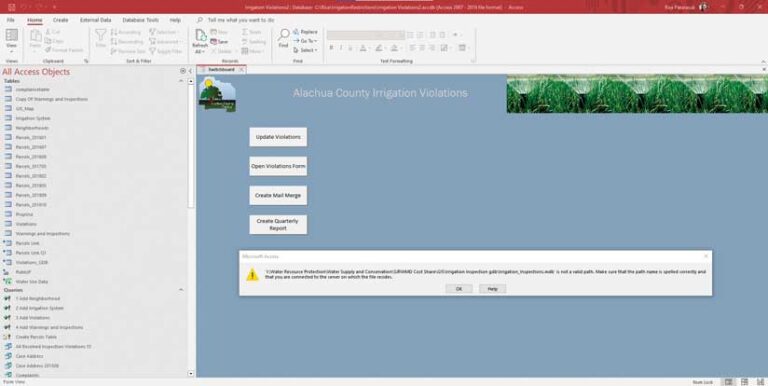
With the previous workflow, a custom-built Microsoft Access interface was configured using forms, SQL, and various URLs or folder paths to link the data sources needed to generate the mailing list. Between 2011 and 2018, this Microsoft Access file was created and maintained by a GIS analyst and a programmer.
However, using Microsoft Access was cumbersome because it required downloading parcel data from the property appraiser every three or four months to generate an updated mailing list so that notices could be sent to irrigation restriction violators. The data was saved in ArcCatalog as a personal geodatabase (.mdb) format file on a shared network drive so that it could be accessed by field staff members and used in Microsoft Access.
Updating the mailing list every few months created a time lag just when time-sensitive enforcement letters needed to be generated and sent. In addition, when multiple properties with the same owner were identified as being in violation, information for each parcel record had to be copied and pasted between tables to generate the mailing list. These processes were time-consuming and tedious.
Emily Rodriguez, a staff member who worked on this project between 2014 and 2016, said, “Because follow-up work in the office took so long, I had to cut my fieldwork short to be able to send the letters the same day. Instead of identifying additional properties with opportunities to save water, I was spending lots of time following lengthy protocols for transfer of information from the field to the computer.”
During the past few years, the workflow did not function properly because URL and file links used by Microsoft Access were broken because folders had been deleted or moved. In addition, the GIS analyst and programmer who maintained the process left the organization and no current staff members knew how to fix the applications. Consequently, there was an urgent need to develop a new, more efficient workflow.
Working More Efficiently Using ArcGIS Online
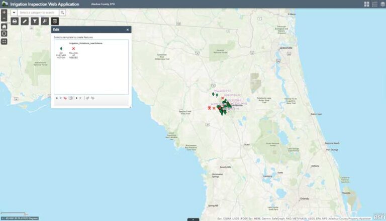
In May 2022, new staff members wanted to use ArcGIS Field Maps to develop a new workflow for the Irrigation Restriction Program. They created a new point feature class with a new schema for field data collection and published it to ArcGIS Online. The feature layer was added to ArcGIS Field Maps.
With recent enhancements, ArcGIS Field Maps could now use ArcGIS Arcade code in smart forms, so fields could be automatically populated with PIN and address data from the property appraiser and added to the feature layer. This saved time and eliminated both manual entry of PINs and the associated data entry errors.
Parcel data automatically updates in ArcGIS Field Maps when it is updated by the property appraiser’s office because its parcel feature layer is a REST service added to ArcGIS Field Maps. Also, mailing list generation is simpler. Staff members can download field data from ArcGIS Online as a Microsoft Excel file that can easily be sorted and filtered to capture values needed to generate a mailing list.
With the new workflow, EPD incorporated data from other agencies including University of Florida’s (UF) H2OSAV data and Gainesville Regional Utilities (GRU) reclaimed water lines data. [H2OSAV (Water Savings, Analytics & Verification) is a UF Institute of Food and Agricultural Sciences (IFAS) Extension program that is working to measurably save Florida water. GRU is a multiservice utility owned by the City of Gainesville, Florida.] These feature layers were also added to Field Maps.
H2OSAV data provides water use data within the GRU water service area. Field staff members can now determine if a property that violates the Irrigation Restriction Code is in a high-water use area and send a warning letter to the owner. However, if GRU data shows that a parcel uses reclaimed water for irrigation, it is exempt from the irrigation code and no action is taken.
“The autofill for parcel ID numbers has improved the efficiency of data collection in the field with less opportunity for data errors. A few new data layers added during the update have been important strategic targeting tools to make more effective use of field time and improve water conservation efforts,” said Hollie Greer, a senior environmental specialist with EPD.
The reclaimed water data layer allows staff members to quickly identify areas where current irrigation restrictions do not apply. The H2OSAV data layer provides a quick resource tool in the field to identify higher areas of water use so that EPD can focus its inspection work and have the most impact.
“It also helps to build a better working knowledge of water use patterns across the county, which is helpful for our existing staff and in training new staff to work more effectively,” said Greer.
In addition to ArcGIS Field Maps, a web application was created so that data collection points can easily be viewed in the office. The Edit widget was added to the application, so Greer could easily make edits, such as adding notes, directly to the data.
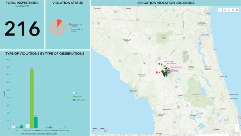
Finally, using ArcGIS Dashboards, a dashboard was created to give staff members and their managers an overview of the program including a summary of the number of properties inspected, violations, and types of violations. Dashboard users can also zoom in/out or pan on the map to see a summary on a particular area of interest.
More Applications for ArcGIS Field Maps
With current ArcGIS Field Maps development, staff members can now collect data more efficiently than they could with the previous workflow, which used ArcPad, ArcGIS for Collector, and Microsoft Access. New staff members are currently being trained to use ArcGIS Field Maps and help with data collection processes. With the success of the Irrigation Restriction Violation Field Map app, EPD plans to utilize ArcGIS Field Maps for other data collection processes, including water sampling for water quality monitoring programs and wetlands field surveys for land development permits.
For more information, contact
Risa Patarasuk, GIS Analyst for EPD
Alachua County Board of County Commissioners
408 W University Ave., Suite 106
Gainesville, Florida 32601
Email: rpatarasuk@alachuacounty.us
Phone: 352-264-6826
Acknowledgements
Many thanks to Hollie Greer and Emily Rodriguez for helping to edit the article and Eliana Bardi, Stacie Greco, and Greg Owen for providing supplemental information.
About the author