World's Tallest Eucalyptus Tree Found with Lidar and GIS
By Aly Lawson, Esri Writer
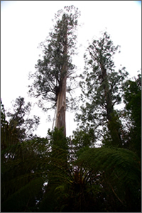 At 99.6 meters, Centurion stands as the tallest known hardwood tree in the world. |
A true giant among trees—the tallest known hardwood in the world—was discovered and mapped using a combination of lidar and GIS, the same technologies Forestry Tasmania uses on a daily basis for managing forests in Australia's southern island state of Tasmania. The swamp gum, a eucalyptus, was nicknamed Centurion and measured at 99.6 meters (326.8 feet) in height and 405 centimeters in diameter. Watch the tree being measured in this video.
While tantalizingly short of the 100-meter mark, Centurion is the world's tallest eucalyptus tree and the tallest flowering plant. Only by few California coast redwood trees are taller. The tallest redwood is 115 meters. Redwoods are softwood trees, which grow taller than hardwoods, however botanists do not classify them as flowering plants.
Centurion was found about 80 kilometers southwest of Hobart, the capital of Tasmania, in a state forest near the Tahune AirWalk. "This discovery was basically a by-product of our sustainable forest management," said Luke Ellis, GIS manager of Forestry Tasmania, based in Hobart. The government-owned corporation manages more than 1.5 million hectares of state forest land, or 39 percent of Tasmania's forests. About half the forests Forestry Tasmania manages are available for sustainable timber production, and a network of formal and informal reserves on the state forests helps the company protect the environmental quality of its forests including flora, fauna, soil, water, and cultural heritage.
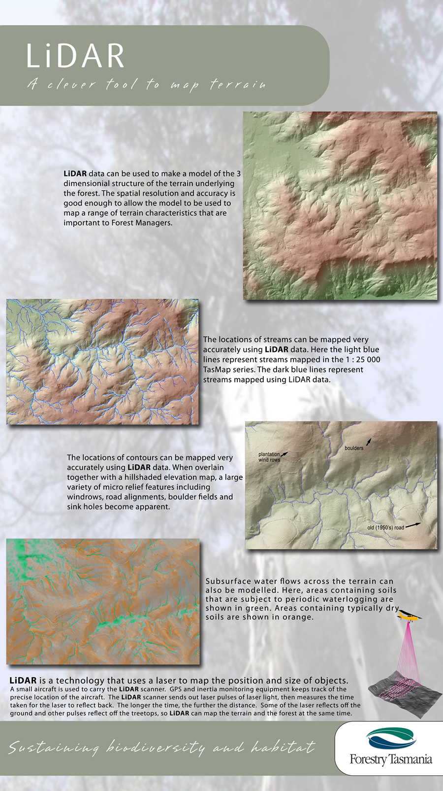 A poster that explains how foresters use lidar. |
Centurion was initially detected during an aerial survey using laser equipment called lidar and analyzed using Esri's ArcGIS software. Lidar (light detection and ranging) is an optical remote-sensing technology that uses laser pulses to measure the properties of scattered light to find range or other information about a distant target. Like radar technology, which uses radio waves instead of light, the range to an object is determined by measuring the time delay between transmission of a pulse and detection of the reflected signal.
The use of lidar is attracting growing interest from foresters. The technology was first embraced by engineers, who recognized its ability to map terrain by accurately sensing ground surfaces, buildings, ore stockpiles, and similar features. It was used to enable more efficient quantity surveying, hydrologic mapping, and civil engineering design work based on accurate, high-resolution digital elevation models (DEMs) of the ground.
When lidar is flown over forests and other vegetation, only a portion of the laser pulses penetrate the canopy and reflect off the ground; the remainder is reflected off the trees and shrubs. Engineers have learned how to filter out the vegetation strikes and leave only ground strikes, from which a ground DEM is built. For engineers, each vegetation strike is just a missed opportunity for a ground strike.
However, foresters quickly realized that by separating the signals into ground strikes and vegetation strikes, they can build two DEMs: one that maps the ground surface and one that maps the top of the tree canopy. By subtracting one from the other, foresters can get highly accurate maps of tree height-maps long used to monitor growth and assess site quality.
 Centurion as seen in Esri's ArcScene. |
"Lidar promises to revolutionize forest mapping and inventory," said Martin Stone, resources manager for Forestry Tasmania. "With traditional aerial photography, accurate photogrammetry is impossible when the ground is obscured, so we were reliant on skilled but subjective manual interpretation. And the use of passive satellite imagery relies on statistical inference that has relatively low reliability at operational scales. Lidar, on the other hand, is an active sensor; it directly measures forest and land structure, accurately and repeatedly.
"We have found that we can use lidar data to model and map tree height, canopy density, and standing timber volumes, even in highly variable forests. And whereas older topographic mapping could only guess at the terrain under dense vegetation, the new lidar-based ground DEMs are accurately revealing streams and contours in great detail."
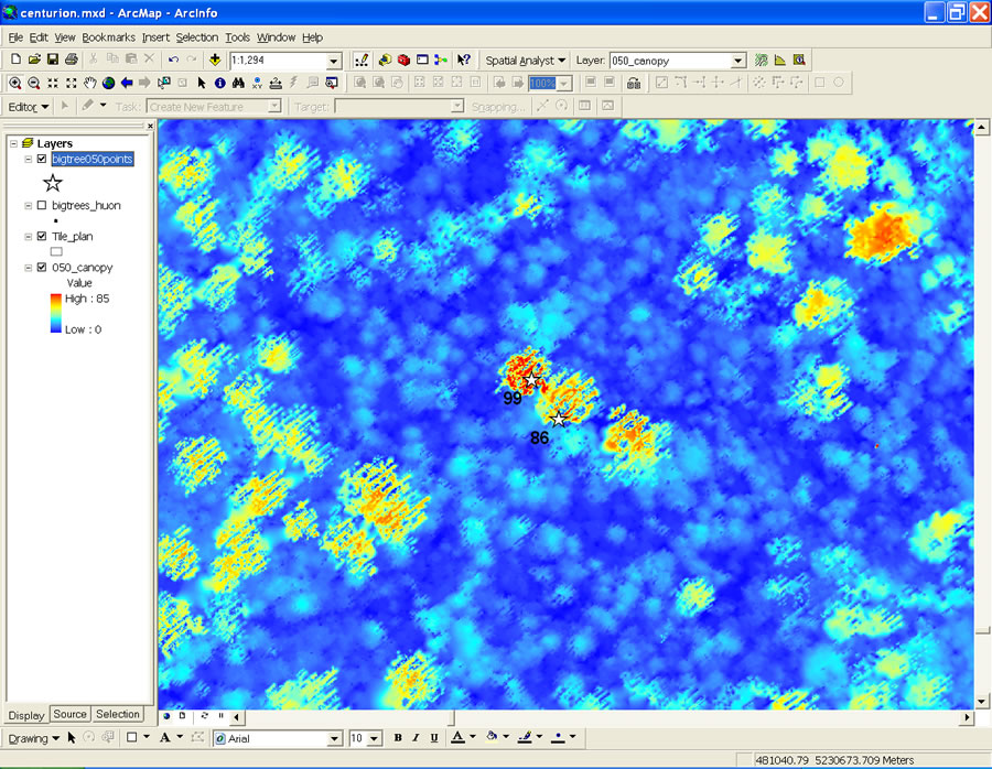 Centurion (99) as seen in ArcGIS Desktop's ArcMap application. This image shows the raster tree canopy surface colored by height. |
For Forestry Tasmania, this means more efficient planning of access roads and cable harvesting, easier delineation of harvest boundaries, improved silvicultural planning, and better environmental outcomes. Maintaining timber inventories should be more efficient, and the spatial variation of forests can be accurately mapped.
Lidar also means using GIS to a great extent. "At an average of two strikes per square meter of forested land, that's a lot of data to store and process," Ellis said about Forestry Tasmania's lidar data workload.
All of Forestry Tasmania's lidar information is stored in the company's Oracle Spatial relational database, which is used for effective data management and integration with other corporate systems. The Oracle data is efficiently replicated to a separate geodatabase, where Esri's ArcGIS Desktop software is used to do the advanced geoprocessing and analysis of the lidar data.
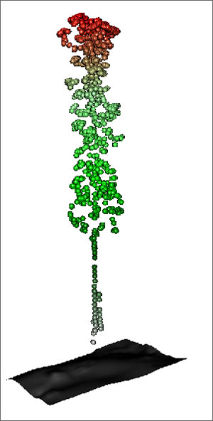 A 3D model of Centurion based on lidar results. |
"Ultimately, the result of our ArcGIS processing is a range of derived products that can be served to our foresters, planners, and engineers as GIS layers such as DEMs, timber volume surfaces, contours, and drainage lines. Most of this information can then be published in map formats, still the preferred medium for our field staff," Ellis noted.
"Our organization is very spatial, and everyone uses GIS in some form, especially in the field offices. The everyday user in forestry tends to work with GIS a lot to query data and browse and print maps. We use ArcGIS to do a range of important tasks-modeling and analysis, processing lidar, deriving spatial statistics, monitoring sustainability indicators for annual reporting, and just knowing how much of what we have is where."
All this, of course, means knowing the location of special trees like Centurion. The tree, which may be 400 years old, has obviously survived some close calls. Evidence of logging dating to the 1950s was discovered nearby. The tree also survived a massive wildfire in 1934 that passed just west of it and another fire in 1966 on its east side.
"No one was looking out for it in those days," Stone said. "We didn't know it was there. But thanks to lidar and GIS, it now has a name and it's on the map-literally." Centurion has now been formally designated as a giant tree and is protected in a preserve in accordance with Forestry Tasmania's policy.