ArcWatch: GIS News, Views, and Insights
January 2013
Educating the Next Generation in Geodesign
Philadelphia University to Launch a Master of Science Degree Program in Geodesign

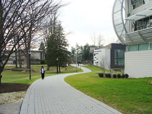
Students stroll on the main campus of PhilaU, which will offer a master of science degree in geodesign starting next fall.
Professionals in fields such as landscape architecture and urban planning will soon get the opportunity to earn a master of science (MS) degree in geodesign from Philadelphia University (PhilaU). It's one of the first such programs in the country.
PhilaU's College of Architecture and the Built Environment will launch the MS program in geodesign in fall 2013.
Geodesign is an innovative design concept that incorporates the latest technologies, such as geographic information systems (GIS), building information modeling (BIM), robotics, and gaming to capture, manage, analyze, and display detailed geographic information. Courses include geospatial analysis I and II, information modeling, collaborative geodesign studios, adaptive design, and environmental policy.
These applications and technologies can be used to develop master plans and designs grounded in sustainable design principles. Students in the program also will develop and test new tools and technologies that will help define future industry software needs.
"Our graduates will be proficient in a geodesign approach to assessment, planning, design, and management processes that are critical to solving twenty-first-century urban problems," said Claudia Phillips, director of Philadelphia University's Landscape Architecture and Geodesign programs. "Students in the program will work on collaborative, interdisciplinary teams and will be actively engaged in applied research projects supported by industry, federal and state governments, and community partnerships."
The MS in geodesign program utilizes an innovative and sophisticated design framework grounded in advanced technology for professionals to use in planning and designing sustainable built and natural environments. The MS in geodesign adds to Philadelphia University's already prominent role in advancing interdisciplinary collaboration, sustainability, and immersion in real-world projects.
The concept for the program arose after members of the landscape architecture faculty attended the first Geodesign Summit in 2010 at Esri headquarters in Redlands, California. After the second summit in 2011, the university made the commitment to start an MS in geodesign program to complement its undergraduate landscape architecture program. (The next Geodesign Summit will be held January 24–25, 2013, at Esri. The keynote speaker will be Bran Ferren, designer, technologist, and cofounder of and chief creative officer at Applied Minds LLC.)
Philadephia University's MS in geodesign curriculum has been developed primarily as a postprofessional degree program for landscape architects, architects, and urban planners and will provide graduates with a valuable new set of skills. Graduates are expected to work for large interdisciplinary firms across the country and abroad and for city, state, and federal governmental agencies such as the National Park Service, the US Department of Agriculture, and the US Army Corps of Engineers, as well as academia.
"The future of design excellence and sustainability across the design disciplines will require ever-increasing complex problem-solving skills to empower creativity," said James Querry, director of enterprise GIS for the city of Philadelphia and a PhilaU adjunct faculty member. "The PhilaU cross-disciplinary masters students will be equipped to apply exciting and rapidly emerging geospatial technologies to lead in defining and solving contemporary design and planning challenges with highly informed sustainable design solutions. Geodesign is 'smart' design."
PhilaU is poised to be a geodesign leader in academia. "With one of the first academic programs in geodesign, Philadelphia University is positioned to become a national educational leader in this new field of study," said Barbara Klinkhammer, executive dean of the PhilaU College of Architecture and the Built Environment. "Graduates will be able to assess multidimensional impacts and implications of design alternatives using the rich mapping and data of geographic information systems and the three-dimensional imaging and modeling of building information modeling."
The MS in geodesign is a 36-credit, full- or part-time graduate program with classes offered evenings and Saturdays. Although the MS in geodesign is designed primarily for professionals in the fields of landscape architecture, architecture, and urban planning, applicants with degrees in other fields will be considered for admission on an individual basis. Students without a strong background in GIS must take an accelerated course in summer 2013.
For more information or to apply to Philadelphia University's MS in geodesign program, contact Claudia Goetz Phillips, PhD, FCELA, ASLA, director, Landscape Architecture and Geodesign at phillipsc@philau.edu or 215-951-5653 or visit the school's website.

