Spring 2008
Spring 2008 |
||||||||
|
|
||||||||
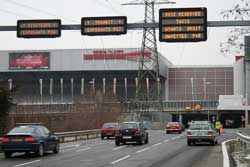
The 2008 European Football Championship (Euro 2008), held June 7�29, was one of this year's major European sporting events. In terms of media coverage, this event is the third largest sporting event in the world followed only by the Olympic Games and the Football World Cup. Co-organized by Austria and Switzerland, Euro 2008 attracted millions of visitors who attended the event's 31 matches—15 played in Switzerland and 16 played in Austria. One of the biggest problems involved in this event was managing traffic. For such an event, the Union of European Football Associations (UEFA) requires host cities to handle 5,000 cars, 200 buses, and 1,750 special category vehicles (e.g., VIPs, guests, sponsors, teams). These vehicles carry visitors not only to matches but also to related activities such as retransmission of the matches on giant screens and other festivities that take place in host cities. Consequently, Geneva, Switzerland, took measures to control the movements of these vehicles and welcome the 800,000 visitors expected during the three-week event. These measures included placing traffic maps around event locations, the use of traffic diversions to moderate the traffic flow, and the establishment of a command center to coordinate decisions. To manage traffic near the stadium, the Geneva police relied on a GIS application called AGIRE that was created by the consulting firm arx iT, a business partner of Esri GeoInformatik AG, the Swiss Esri distributor, and Citec SA, a transportation consulting firm, in collaboration with the Transport and Geomatics Department of the Canton of Geneva. AGIRE has been used by the Geneva police to manage other large events such as the Motor Show, the G8, the World Telecom Exhibition, and the World Summit on the Information Society (WSIT). What Is AGIRE?To ensure good traffic management during large events, the police put a complex monitoring system in place. This system includes a centralized control unit and several action teams on the ground. The centralized unit receives information from the teams and from sensors installed around the site. These sensors supply data in real time for cameras, vehicle counters, and other devices.
The AGIRE application uses this real-time information to provide a global view of traffic conditions and the occupation rate of parking areas. It also has a decision-making module that preconfigures the application with scenarios for responses to developing situations. For example, when a given car park becomes full, an alert informs the system manager and suggests he redirect traffic to another car park. Traffic is redirected by modifying variable message signs (VMS) on main roads. The Contribution of GISAGIRE offers numerous advantages for managing major events. Its simplicity makes it easy to use. Teams on the ground appreciate its visual and ergonomic qualities. The contribution of a GIS is decisive in AGIRE's approach. Because every object (road section, car park, VMS, building) is georeferenced and mapped, their manipulation is very intuitive. The interface contains different modules that allow traffic to be managed appropriately. Users can easily switch from one module to another to visualize data—such as car park occupancy rates—as it changes in real time. By supplying this overview, traffic fluidity can be visualized at any moment. The modules for managing VMS and parking areas allow users to interact with the communication tools and agents on the ground. The decision-making module suggests a scenario appropriate to the current situation taken from a list of predefined scenarios. A new module allows incidents that occur during an event to be logged for use in postevent debriefing sessions. In addition, data stored in the database is archived for statistical purposes. The system is relatively complex. It combines different devices and technologies such as road traffic counters, traffic cameras, VMS, secured Short Message Service (SMS) transmissions, the Web, and spatial databases. The strength of the system lies in its capacity to concentrate the data received in a single database (Oracle/ArcSDE) before distributing it as needed. The independence of the hardware and the software components give the application great flexibility and allow it to be integrated with other information systems. Because the application is used for events controlled by the police, a very high level of security is required.
Other georeferenced data, such as public transport networks, can be added to the project data, which provides flexibility and potential additional decision-making functionality. For example, the system could create alerts with spatial constraints for incidents detected within a given perimeter. Esri Technologies UsedThe application consists of an ArcView project customized to meet the operational requirements of traffic management—handling large volumes of data in real time in a highly secure environment. AGIRE has been developed in ArcGIS 9.2 using ArcObjects in a .NET environment with data stored in an ArcSDE/Oracle database. Application's Success and FutureThe AGIRE application has become indispensable to the Geneva police for major events such as Euro 2008. Traffic management is a growing problem as more visitors travel to events by car. Without the decision-making and preplanning capabilities of the application, car parks would quickly be filled while visitors waited in long queues to enter or exit parks. The application is continually developed to integrate the latest technologies. There is no lack of ideas for enhancements. New developments include real-time location of police officers using GPS and a system that alerts decision makers in urgent situations via SMS. In the near term, project goals include the creation of simulations for predicting traffic movements. For more information, contact 2008 European Football Championship: About the AuthorDavid Beni graduated with a degree in software engineering from the Swiss Federal Institute of Technology in Lausanne (EPFL) and received an MBA from Geneva University. During college, he became interested in GIS. In 2001, he founded arx iT, an ISO 9001-certified consulting firm specializing in technology and GIS solutions integration. Since 2003, Beni has focused on the analysis of information systems and project management. |