ArcUser Online
Summer 2011 Edition
A GIS App for the Facebook Generation
Bringing The Atlas of New South Wales to life online
By Dr. Pedro Harris, New South Wales Land and Property Management Authority; Stephen Lead, Ajilon Australia; Danny Savic, Azuron Ltd.; and Tim Lucas
This article as a PDF.
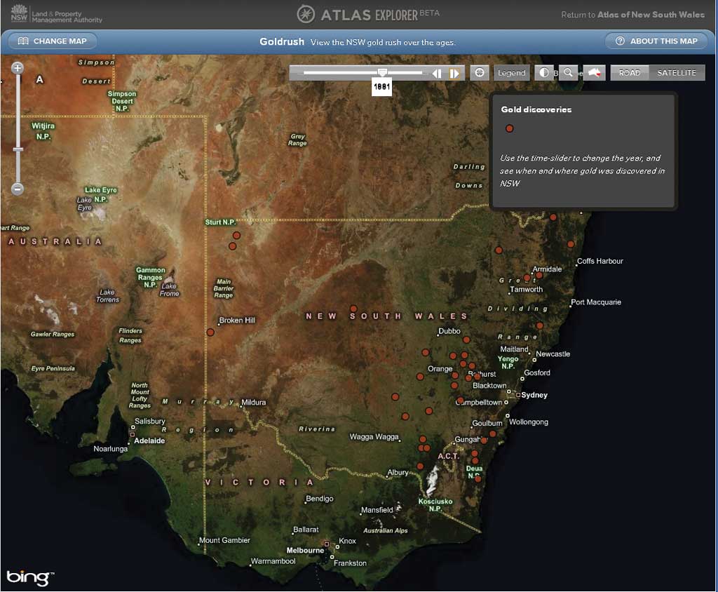
Many datasets, like this one showing the Gold Rush, are based on historical information, so the new time-aware functionality was configured to allow users to visualize changes over time.
The authors designed a JavaScript-based web mapping application called Atlas Explorer, which makes the rich content of The Atlas of New South Wales accessible through an intuitive interface that eliminates the learning curve associated with many mapping sites.
"Read the manual."
Increasingly, these words are falling on deaf ears. The web is full of complicated mapping applications, laden with tools, check boxes, and drop-down lists, designed by experts, for experts. The user is expected to learn how to use the system. To address this problem, a new breed of applications is emerging with elegant and intuitive interfaces that give a more satisfying user experience.
The Atlas of New South Wales
Our aim was to build a simple but powerful GIS application aimed at the Facebook and iPod generation that never reads the manual and expects things to "just work." Our starting point was The Atlas of New South Wales, a new 200-page printed book. This book, written by experts from the New South Wales (NSW) government, academia, and industry, provides a comprehensive picture of NSW. Topics include the history of indigenous and European people, European exploration, analysis of the modern-day population, the history of elections over the past 150 years, the economy, and the environment. Our goal was to bring the printed book to life in an online site, complete with interactive maps. The finished application may be seen at atlas.nsw.gov.au.
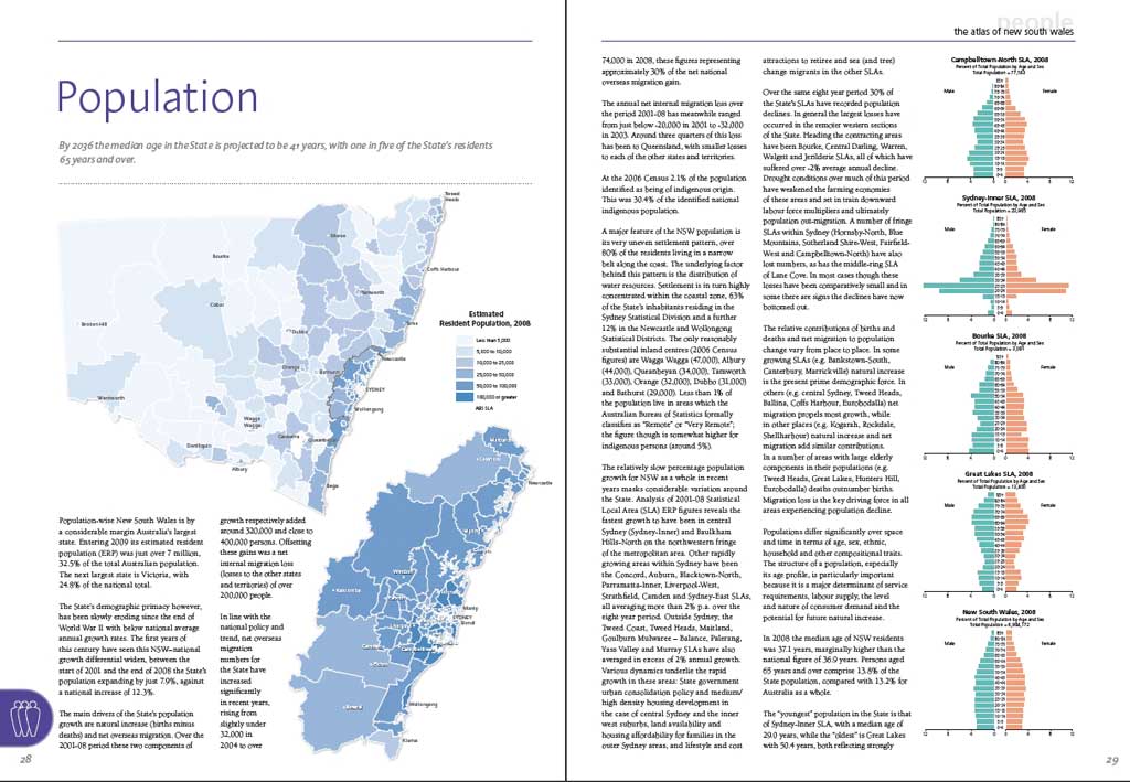
The website, atlas.nsw.gov.au, is based on The Atlas of New South Wales, a 200-page printed book.
Atlas Explorer Map Viewer
We wanted a full-screen map viewer that would allow the user to navigate anywhere in New South Wales. We turned to the ArcGIS API for JavaScript version 2.1 to create the new Atlas Explorer mapping application.
A GIS with No Tools?
To keep things simple, we needed to minimize the controls used to interact with the map. With no additional coding, the ArcGIS API for JavaScript provides the ability to
- Zoom in by double-clicking.
- Zoom in and out using the mouse wheel.
- Zoom in and out using the navigation control.
- Zoom to a box using the Shift key.
- Pan the map by holding the left mouse button while dragging.
Using the JavaScript map's built-in behaviors for navigation, we eliminated the need for Zoom In, Zoom Out, and Pan tools, which resulted in a far simpler user interface. Using most GIS interfaces, it is necessary first to select an Identify tool, then click on a feature to retrieve its attribute values. To avoid this requirement, we used feature layers as overlays on the basemap. Running a listener for the onMouseOver event meant that an Identify tool wasn't necessary, because the features themselves became identifiable. Incorporating the Identify tool's functionality into the layer's own behavior allowed us to dispense with the Identify tool, further simplifying the user interface.
In our case, when the mouse is moved over a polygon, the cursor changes to a pointer and the feature is highlighted. This alerts the user that additional information is available. (A separate listener event removes the highlight graphic when the mouse is moved away from the feature.)
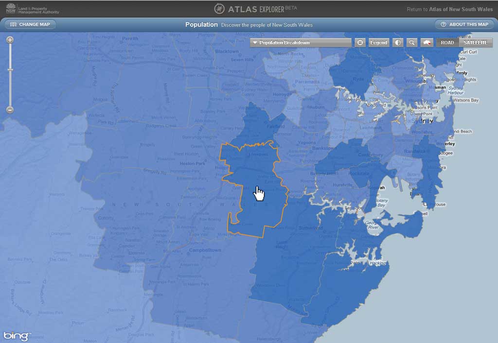
In the Atlas Explorer, navigation is controlled by the map, and the Identify functionality is controlled by the layer.
No Table of Contents?
We avoided the requirement for a complex table of contents by allowing only one theme to be visible at any time. This removed the need for check boxes to control layer visibility and prevented the problem of multiple, overlapping layers. Because the map extent does not change when the theme is changed, the user may still compare various themes within the same area. For a site aimed at the general public, this seemed a reasonable compromise to avoid undue complexity.
Time-Aware Layers
Many datasets in the atlas are based on historical information, so the new time-aware functionality was configured to allow users to visualize changes over time. Setting up a time-aware layer is a simple process:
- Enable time on the layer's Properties dialog box in ArcMap.
- Configure the time slider in ArcMap.
- Create an ArcGIS Server map service from the map document.
- Initialize a time slider in the online mapping application.
Once these steps have been completed, a new time extent property is set at the map level. All layers in the map automatically update to reflect changes in the time extent and only show features that are valid for the specified time. In the atlas, this allows users to visualize historical processes, like the progress of European settlement over time, and brings the historical datasets to life in an intuitive manner.
Challenges
The use of feature layers removed the need for an Identify tool but posed its own set of challenges. Displaying complex polygon features across NSW resulted in large download sizes and long download times. The solution was to use the maxAllowableOffset parameter to allow the features to generalize on the fly. By listening for the map's onZoomEnd event, the maxAllowableOffset value could be optimized for any map scale.
Conclusion
ArcGIS Server and ArcGIS API for JavaScript provide powerful tools that can be used to visualize complex datasets simply and easily. An added benefit of the JavaScript API was that it removed any dependencies on third-party plug-ins, so our site could run on any web browser.
A user-centric interface and workflow are essential if the goal is to engage with the non-GIS community. Using the built-in behaviors of the ArcGIS API for JavaScript for the map and layers can help simplify the user interface while still allowing rich and engaging interactivity. For more information, see The Atlas of New South Wales at atlas.nsw.gov.au, follow @AtlasOfNSW on Twitter, or contact Stephen Lead at Stephen.Lead@ajilon.com.au.
About the Authors
Pedro Harris is the chief information officer at the New South Wales Land and Property Management Authority (LPMA). LPMA is the principal mapping authority for NSW and maintains a portfolio of GIS and mapping websites. The Atlas Explorer for the Atlas of New South Wales website is LPMA's first viewer targeted at the general public rather than government, business, and industry.

Stephen Lead
Stephen Lead is a principal GIS consultant at Ajilon Australia, a consulting, project management, and system integration specialist located across Australia. Prior to joining Ajilon, Lead spent eight years working at ESRI Australia Pty. Ltd. and ESRI (UK) Ltd. He is a previous contributor to ArcUser.
Danny Savic is a web technology specialist at Azuron Ltd., a consulting and system integration firm based in Sydney, Australia. Savic has worked on numerous web-based projects for clients both large and small.
Tim Lucas is a designer based in Sydney, Australia, who provided invaluable input into the user experience and interaction design for this project.