Winter 2009/2010
Winter 2009/2010 |
|||||||
|
|
|||||||
Design and Collaborate over the Web
Web Editing and User-Generated Content (UGC) at ArcGIS 9.4 |
|||||
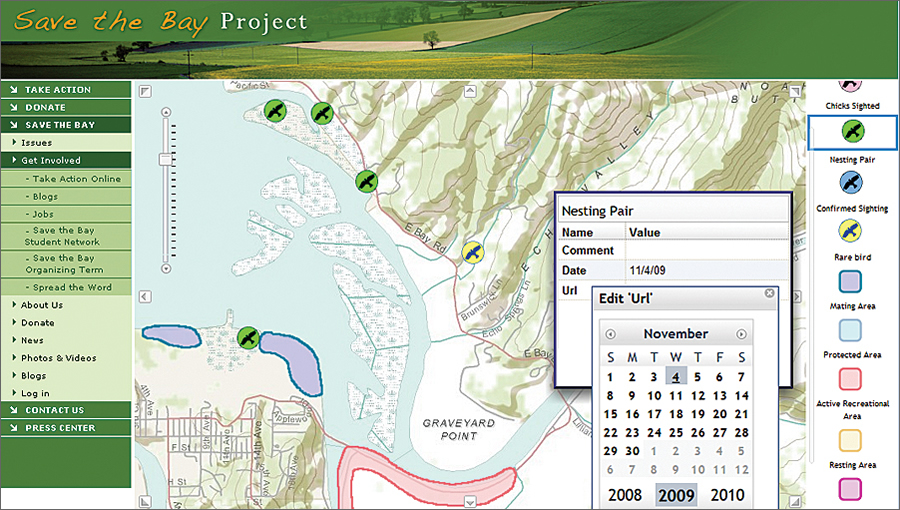
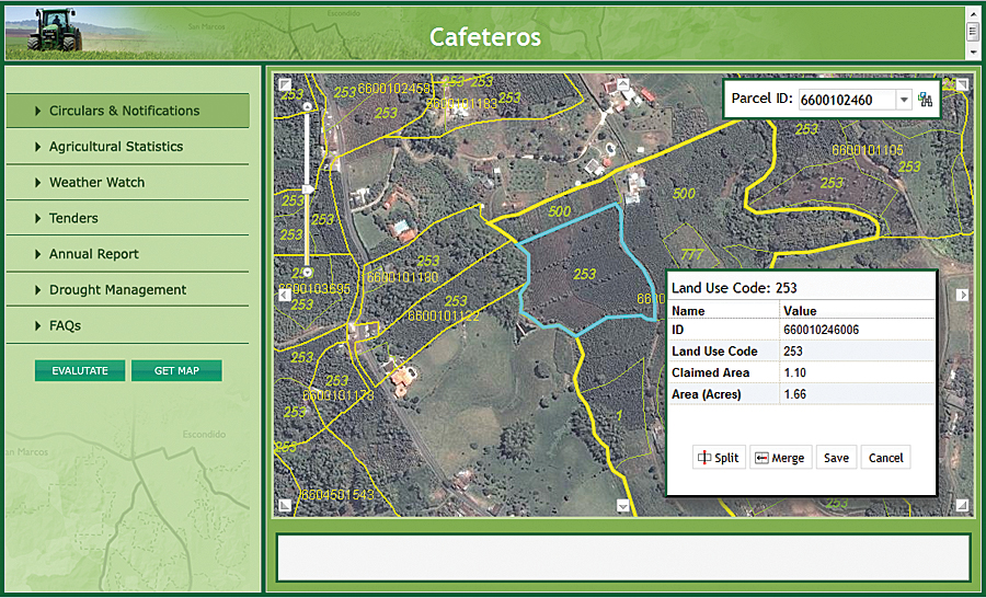
ArcGIS 9.4 Web editing will change the way organizations collect and manage spatial data. It gives users the ability to modify geographic content within any Web mapping application and provides a venue for online communities to become active contributors to the geodatabase. Web editing makes it easy to capture ideas and observations for distributed problem solving and extend GIS editing capabilities to more people within the organization. These capabilities can also be used to capture user-generated content (UGC). What Is Web Editing?Web editing involves modifying or adding content to the geodatabase via a Web application. Editing is performed using a set of simple sketching tools that allows users to draw new features or edit existing features directly on a Web map. Users can also edit attributes and add attachments, such as digital photos. At 9.4, Web editing capabilities are supported in all client applications, including browser-based applications built with ArcGIS Web Mapping APIs (JavaScript, Flex, and Silverlight/WPF), ArcGIS Mobile applications, and ArcGIS Desktop. Web editing is optionally enabled when a map is published to ArcGIS Server. The user can choose to provide feature-level access to the map service while configuring service capabilities. Web editing capabilities include an enhanced geometry service that supports new geometric operations, such as union, intersect, trim, extend, cut, offset, auto-complete, and reshape. Why Is Web Editing Important?Web editing provides fast, intuitive editing opportunities for users of the open Web. While they don't replace the sophisticated editing tools of ArcGIS Desktop, Web editing capabilities allow organizations to extend spatial data editing to a larger, more diverse audience. GIS professionals will save time by distributing focused editing tasks that can be handled more efficiently by subject matter experts. In addition, geographic sketching, a central component of the GeoDesign concept, will allow users to quickly sketch their design ideas on top of digital maps and get immediate feedback on the performance or impact of the design being proposed. Sketching enables rapid testing of multiple design proposals and alternatives. Feature services (services with feature access) provide end users with a simple, easy-to-understand view of the geodatabase. They can interact with individual features, feature attributes, attachments, and relationships to other features or tables and make basic changes to those elements. Web editing in ArcGIS is template based. At 9.4, feature templates (authored in ArcGIS Desktop) are published with the feature service and carry over layer properties, such as how features are symbolized in the map. Templates also allow the publisher to control which attribute fields can be viewed and edited, as well as provide access to subtypes and domains. Authoritative data editors can use feature services too, but they are not restricted to the simple Web editing toolset. ArcGIS Desktop users can create a local copy of the service layers, edit features using ArcMap editing tools, then synchronize those changes back to the service via ArcGIS Server. Who Will Use Web Editing?
One of the fastest-growing audiences for Web mapping applications is Web citizens. Web editing empowers ordinary citizens to contribute their observations by merely drawing on an online map. They can create new features describing the shape and location of a problem or concern. They can attach a photo to the feature or simply take a picture with a smartphone and send it. In this way, people become dynamic sensors moving through the landscape, annotating the map as they go along. Organizations might incorporate these observations to gauge citizen response to a proposed policy or build a new kind of social geography that changes the way leaders look at their communities. Mobile workers can use Web editing to tap into and edit authoritative datasets on-site. They can quickly improve the accuracy and value of the data with their observations because those changes are synchronized with the GIS server, and the new information is immediately available for others to use. Similarly, an organization's non-GIS office staff can use internal Web applications to keep feature attributes up-to-date, attach supporting digital documents to a feature, or validate the status of assets and inventories. GIS professionals, as well as a new breed of geodesigners, will use Web editing to sketch out ideas, create prototype designs, and visualize what-if scenarios. They can take a what-if sketch and turn it into a topologically sound, as-built layer and maintain the entire history of changes and ideas. ConclusionNew Web editing tools and services available in ArcGIS Server 9.4 allow everyone—from authoritative data editors to citizens on the street—to contribute content to the geodatabase. GIS professionals can proactively shift simple editing workloads to appropriate staff. With this expanded capability, people can share and build a common understanding of the issues affecting their environments and work together to design the best solutions. More InformationPlease also see the ArcGIS 9.4 Web Editing poster. |