Winter 2009/2010
Winter 2009/2010 |
|||||||
|
|
|||||||
GIS Revitalizes Sewer Maintenance Capabilities in Ontario's Capital
Infrastructure Inspection Streamlined |
|||||
Highlights
Across Canada, sewer maintenance has become a growing priority among municipalities, and there has been a significant shift to rehabilitate sewer lines before they break. Factors such as aging infrastructure; population growth; poor quality control; and lack of consistency in design, construction, and operation practices have negatively impacted municipal infrastructure in recent years. Ontario alone has a massive backlog of water system repairs and an infrastructure deficit estimated in the billions, making it more important than ever for municipalities to implement a standardized process for acquiring and reporting reliable infrastructure data.
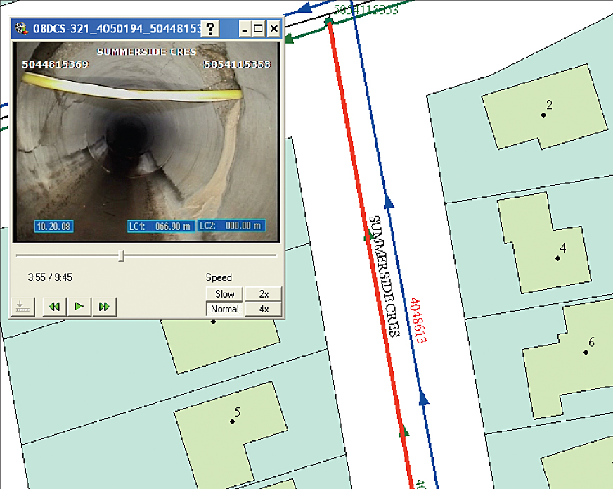
Toronto Water, the water department of the City of Toronto, Ontario, operates under a mandate of ensuring high water quality while protecting public health and safety and the environment. This objective is backed by the city's various improvement projects that include the continual inspection and maintenance of storm, sanitary, and combined sewer pipes. In 1998, when the City of Toronto amalgamated, Toronto Water was tasked with consolidating datasets from a variety of sources into a single system. This proved problematic, as data was stored in varying formats that were often difficult to access, for example, in files that were too large to download or on outdated media formats, such as VHS tapes. The city recognized that it was in urgent need of a standardized process so it could effectively compare inventory drawings against the realities in the field and verify structural defects in pipes, maintenance issues, and the accuracy of manhole positions. In 2008, after a successful pilot project, the city commissioned CTZoom, a Montreal, Quebec-based firm and Esri Canada Limited Business Partner, to install industrial inspection computers running its asset management software—CTSpec—in closed-circuit television trucks across the city. CTSpec is a data collection and analysis tool that leverages ArcView to provide a spatial component to infrastructure maintenance. With the software's video feature, users can now click an asset within ArcView to pull up a video of that asset. Out with the Old, In with the NewExplains Antonio Longo, supervisor, District Contract Services, Toronto Water, "One of the biggest challenges with our previous asset management software was that inspectors and contractors would have to manually input road names and pipe and manhole numbers to analyze data on a specific asset, and this left a lot of room for error." In addition, Toronto Water inspectors and contractors often recorded the results of their observations using the industry-specific data acquisition sewer.dat software. While this tool provided a mechanism to rate the conditions of the assets being assessed, it did not enable users to spatially view inspection data results. But now, the city's new infrastructure maintenance program has strengthened city inspectors' ability to manipulate data. Inspectors and contractors just click an asset, and a header box pops up containing the desired information, such as name, location, and work required. They can quickly view a video and accurately assess inventory assets, and CTSpec also includes an automated tracking service that updates the status of asset conditions. The inspection unit's computers are synchronized with personal digital assistant (PDA) technology so that Toronto Water contractors can complete manhole and pipe diagnosis on handheld devices directly into a GIS that is easily shared with other contractors throughout the city. A Snapshot of the City
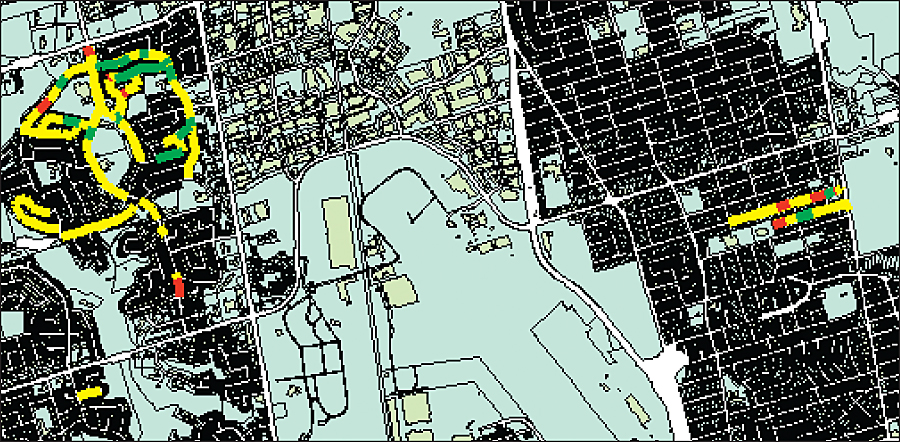
The infrastructure maintenance program can now output ArcView software-based, multilayered digital maps that make it possible to proactively plan infrastructure maintenance activities. For example, a yellow layer identifies pipes that have been inspected, a green layer presents the operational performance grade of the pipe (the extent to which the pipe requires cleaning), and a red layer provides the structural integrity grade of the pipe so that inspectors can predict the likeliness of a collapse. "We can now create a complete snapshot of the city," says Longo. "The spatial component lets us see the work that has been completed and identify work that still needs to be done." The City of Toronto has now fully integrated GIS into its daily operations, which has improved both planning capabilities and cross-departmental access to information. For example, thematic maps can now be easily output by the operations team and forwarded to the asset management department so that it can prioritize assets in need of repair and accurately project its required budget for the coming year. This effective system of reporting ensures that the City of Toronto meets Public Sector Accounting Board compliance regulations, which require Canadian municipalities to include an accurate account of their tangible capital assets in annual financial statements by 2009, while enabling the city to identify and rehabilitate depreciating assets. "We now use a five-point rating scale to assess the structural integrity and operational performance of assets and better understand the rate at which an asset will deteriorate, along with the projected useful life of that asset," explains Longo. "Once an inspection is complete, a report containing a list of inspected pipes and manholes, along with the date of the inspection and the site where the asset is located, is created." "The real advantage of these reports is that each asset listed is hyperlinked to a movie, along with images of the pipe/manhole, and there is no need for extra software to view the images," says Alain Lortie, president of CTZoom. "This in turn enables the creation of a historical legacy of completed work." More InformationFor more information, contact Antonio Longo, supervisor, District Contract Services, Toronto Water (tel.: 416-392-4164), or Alain Lortie, president, CTZoom (e-mail: a.lortie@ctzoom.com; tel.: 888-965-8987, or 450-965-8987, ext. 222). |