Winter 2004/2005
Winter 2004/2005 |
|||||||
|
|
|||||||
Determining Recreational Suitability for Conditions That Do Not Yet Exist
Saving the Kissimmee River of Central Florida With GIS |
|||||
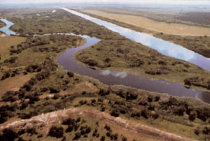
Even before they had finished the project in 1971, the Army Corps of Engineers had decided that channeling the Kissimmee River in central Florida was not a good idea. In seven years, the Corps had converted 103 miles of free-flowing river interlaced with wetlands and teeming with wildlife into a 56-mile, straight, uniform channel. During the years that followed channelization, the South Florida Water Management District found that 90 percent of the waterfowl and 43,000 of 60,000 acres of floodplain had vanished. In the meantime, the area experienced some of the country's most rapid growth. Nearby Orlando saw the development of Disney World and a number of other theme parks, which greatly increased the number of tourists and tourism-related businesses. The local people adopted airboating, while retired folk from colder climates arrived with motorboats. The balance of nature in the Kissimmee watershed was upset because of many factors. In 1981, the Resources Rivers Act directed the district and others to provide recreation in "an environmentally acceptable manner." The district contacted the University of California, Berkeley, where scientists developed four restoration proposals that were tested in 1984 and 1985. One of these proposals has been used in restoring the river's entire length. By 1990, the restoration area was already providing hiking, picnicking, fishing, boating, canoeing, and camping. "Save Our River"When the Kissimmee River Restoration Act was passed in 1991, it set the stage for restoring the ecosystems in addition to providing recreation. Shortly thereafter, EDSA (Fort Lauderdale, Florida) was hired after an extensive competitive analysis to lead a team of landscape architects, hydrology engineers, wildlife experts, vegetation specialists, and market analysts. The team prepared a recreation management plan for the 56-mile river corridor that encompasses approximately 60,000 acres of land. Because the district had already been working in the ArcInfo GIS environment and had a great deal of data available in that format, EDSA prepared its analyses principally using ArcInfo along with other available software. What was unique about the Kissimmee "Save Our River" restoration project was that the base conditions did not yet exist. At the time of the study, the channel had not been removed and the historic riverbed had not yet been restored. The vegetation had not yet regenerated itself, although studies showed that natural regeneration was likely. The GIS allowed the team to study a future, restored floodplain. From a planning perspective, as landscape architects, EDSA was charged with developing a methodology for determining recreational suitability for conditions that did not exist. The methodology that was prepared was scrutinized by the scientific community from the South Florida Water Management District and was found to be a sound scientific model for determining recreational suitability while not degrading what would be the restored river ecosystem. MethodologyThe team took on the task of documenting the existing recreation facilities, studying population projections for the area, and estimating future demand for various types of recreation. The team determined the number of people currently using the study area through permits issued for boating, fishing, and hunting and from the state Parks Department records. The team then developed environmental restoration proposals in areas removed from heavy recreation. Its primary objective was to produce a recreation and natural resources management plan that would not degrade the restored Kissimmee River ecosystem. Since the river was not in its restored condition, the recreation effects had to be estimated against a future, healthy ecosystem. The best way this objective could be reached from a planning and methodology standpoint was to utilize ArcInfo software to model what would be the postrestoration condition. Assessing the Land
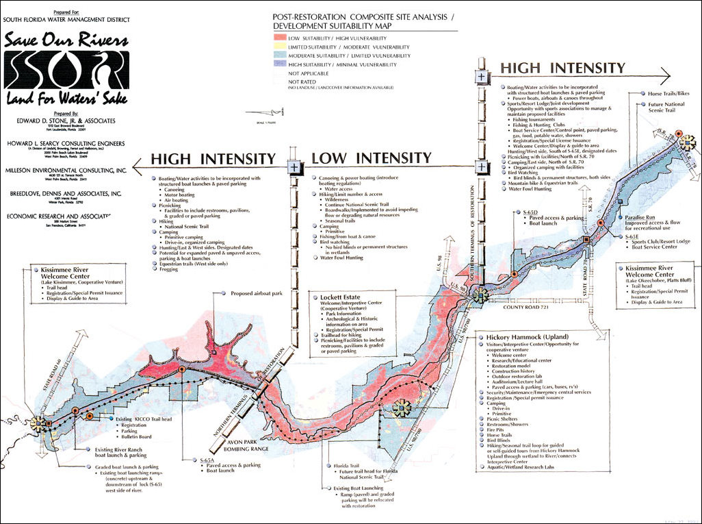
Six components were studied as shown below. A vulnerability model was prepared for each. The vulnerability rating assessed how much recreation uses would affect each site characteristic. A few components also had quality models prepared. The quality ratings measured the potential of that characteristic to provide recreation use. In these examples, the quality model output was combined with the vulnerability model output to yield composite vulnerability maps. The mathematical and geographic operators of ArcInfo were employed, following the rules of each model, to produce the six vulnerability maps. At the end, all six vulnerability maps were combined to form the Overall Composite Vulnerability Map. From this final map, restoration, recreation, and management recommendations were made. Vegetation and Soils Characteristics—There are essentially four vegetation groups in the study area (upland forested and nonforested and wetland forested and nonforested). With several subgroups, 18 plant community or land cover categories were studied. Because of the hydric nature of the soils and their strong link to the vegetation types, vegetation and soils were studied together. This work was directed by Milleson Environmental Consulting, which had done much of the field mapping in 1980. Hydrologic and Physiographic Conditions—Five riparian zones were identified: channel, floodplain, transitional zones, tributary and water courses, and uplands. Hydrologic conditions were described by duration, velocity, stage-discharge relationships, stage-recession rates, and floodplain inundation frequencies. Physiographic conditions refer to the water conveyance, specifically the river channel, canal, and floodplain. Howard Searcy Consulting Engineers developed the model for hydrologic and physiographic conditions. Wildlife Habitat—The Habitat Evaluation Procedures developed by the U.S. Fish and Wildlife Service in 1976 were used by the wildlife consultant, Breedlove, Dennis & Associates, Inc. From a list of 25 indicator species, models were developed and run for 11 species. The standard for evaluation of habitat conditions is the habitat unit. Habitat units are determined by multiplying the acreage of specific habitat types by a measure of habitat quality called the Habitat Suitability Index. Scores were derived for Florida water rats, bobcats, pig frogs, black crappie, common yellowthroat, Florida ducks, ring-necked ducks, herons, egrets, field sparrows, and wild turkeys. Eight of these species live in wetlands, and three species are associated with uplands. The maps for all 11 species were combined according to a set of rules to yield the Composite Habitat Suitability Map. Visual Resources—EDSA adapted the Bureau of Land Management's Visual Resource Management System to develop a model for assessing visual quality. This model used seven visual variables (landform, vegetation, water, color, adjacent scenery, scarcity, and cultural modifications). The model for visual absorption was based on six landscape variables (slope, soil stability and erosion potential, soil/vegetation contrast, vegetation regeneration potential, soil, and rock color contrast). A set of Visual Resources Rules of Combination was applied to the output of these two models in order to develop the Composite Visual Resources Vulnerability Map. Historic and Archaeological Resources—The Florida Division of Historical Resources, Florida Site File, was the source of the information on 29 historic sites within the study area. The immediate area of each site was defined as a circle 500 feet in diameter. Three additional concentric rings of 250 feet each were plotted by the GIS around each site. Moving from the center, each successive buffer zone had a lower vulnerability rating and a higher development potential. Recreation Development Potential/Ownership—Five ownership categories were used to determine the recreation development potential. Lands already owned by the district present the fewest obstacles to immediate development and were rated highest. Three categories of ownership represent moderate recreation potential: those already slated for acquisition, state-owned lands, and federally owned lands. Some of the lands with the lowest recreation development potential are owned by the district; they are used for nonrecreational purposes, such as grazing, and will remain as such. The People's Choice for Land and Water RecreationOnce these six models were combined to form the Post-Restoration Composite Site Analysis/Development Suitability Map, another team member, Economics Research Associates of Los Angeles, used input from an earlier citizens' design charette to project the recreation demand and study the existing supply of recreation amenities. The supply and demand ratio was used to recommend total quantities for each of 28 recreation types. Converting the digital maps into hand drawn maps, EDSA then prepared three alternative solutions meeting these goals, which it presented to the district and the local community. The final compromise was developed manually into the Kissimmee River Conceptual Land Use and Natural Resource Guideline, also known as the "concept plan." ConclusionWhen this planning study was developed and accepted by Kissimmee authorities, the restoration work had not yet begun. But by May 2004, according to the South Florida Water Management District, approximately 11,000 acres had been restored. This article is derived from a chapter in the Esri Press book GIS for Landscape Architects (ISBN: 1-879102-64-1) by Karen C. Hanna. Esri Press books are available at better bookstores, online (www.esri.com/esripress), or by calling 1-800-447-9778. Outside the United States, contact your local Esri distributor. For more information about the Kissimmee River restoration project, contact Paul Kissinger, associate principal, EDSA (tel.: 954-524-3330, ext. 268; e-mail: pkissinger@edsaplan.com; Web: www.edsaplan.com). Acknowledgment is given to Fred Davis, director, Land Stewardship Division, and Lee Henderson, project manager, both of the South Florida Water Management District. |