Winter 2002/2003
Winter 2002/2003 |
|||||||
|
|
|||||||
New at ArcGIS 9: ArcGIS 3D Analyst With ArcGlobe |
||||
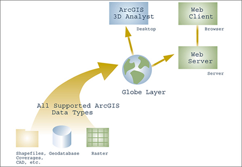
The ArcGIS 3D Analyst extension at ArcGIS 9 will include a number of improvements for 3D GIS and add the capability to visualize multiscale global data in 3D using a new application, ArcGlobe. ArcGlobe allows users to view and analyze very large amounts of GIS data seamlessly and with extremely fast display speeds. Featuring an advanced indexing mechanism, ArcGlobe allows the user to pan and zoom with no perceivable hesitation on many gigabytes of data at once. ArcGlobe is an easy-to-use 3D visualization application. Out of the box, image and terrain data is present and available for the entire globe. It is already available for the user to interact with. Adding your own data is straightforward since ArcGlobe supports all data formats supported by ArcGIS, including shapefiles, coverages, geodatabases, rasters, CAD, and much more. Once you add data, it is dynamically transformed to its appropriate location on the globe. For example, multiple data sets at varying resolutions can be transparently combined to best represent the surface (both imagery and terrain). ArcGlobe can handle extremely large amounts of data because it uses an intelligent scale dependent paging mechanism that works in conjunction with multiple levels of detail. As a result, data is loaded in and out of memory as needed. The data is generalized when viewed from a distance while full detail is displayed as the observer zooms in. ArcGlobe utilizes a multithread approach to data and, therefore, preloads data based on the users actions, eliminating display "freezing" during redraws. Because intelligent data handling reduces the strain on system resources, ArcGlobe eliminates the need for extremely specialized hardware for 3D visualization.
Changes in surface detail are handled continuously and smoothly. Unlike other simulation applications that bring in higher surfaces abruptly causing visual "pop"-like anomalies, ArcGlobe gradually morphs the surfaces in resolution. This makes it easy to combine multiple resolutions of elevation models without sacrificing display quality or performance. Until recently, 3D global data visualization has not been a practical application because data sets of any magnitude would quickly overcome the memory and graphics resources of 3D applications in most desktop computers. ArcGIS 3D Analyst 9 ArcGlobe bypasses these limitations by varying dynamic data access and tiling to produce many different levels of detail as the users interact in real-time with gigabytes of data. At ArcGIS 9, the new ArcGlobe application included with ArcGIS 3D Analyst promotes a seamless view of geography because a user's data holdings are blended into the global data and views provided with ArcGlobe. The viewing context is a continuous sphere in true 3D space. There is no "edge of the world." Because of this, many users will use ArcGlobe as their default display and query application. Esri plans to make the ArcGlobe technology available first in ArcGIS 9 3D Analyst. At the initial release, ArcGlobe will be a separate application within ArcGIS 3D Analyst similar to ArcScene. As such it provides the same benefits of tight integration with ArcGIS including a common user interface, open data support, and familiar Visual Basic for Applications (VBA) and common object model (COM) customization. Later releases of 3D Analyst will merge ArcGlobe and ArcScene into a single application. In addition, future ArcGIS releases will support serving globe layers over the Web to lightweight clients. For more information on ArcGIS 3D Analyst, visit www.esri.com/3danalyst. |