Peru and Mexico—Esri T-shirts at Ancient Icons of the Western Hemisphere
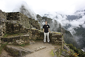
Scott Rawhouser, GIS analyst, Allentown, Pennsylvania, wore his Esri T-shirt while visiting Machu Picchu in Peru. Talk about a high!
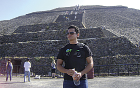
Abdiel Quezada, departmental applications specialist, Regional Geospatial Service Center, El Paso, Texas, posed with his Esri T-shirt in front of the Pyramid of the Sun in Teotihuacan near Mexico City. He was acting as tourist guide for a group of friends from the Czech Republic.
Mountain So High!
| Online Only Photo |
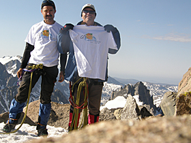
Dr. Ruedi M. Haller (left), geographer and head of the GIS Department of the Swiss National Park, and Dr. Pius J.G. Hauenstein, forest engineer and specialist for GIS and aerial image interpretation for several National Parks in the Alps, reached the summit of Gannett Peak, the highest mountain in Wyoming and part of the continental divide. They'd just come from an Esri conference—which explains the crisp, sparkling brand new Esri T-shirts!
Dr. Ruedi M. Haller (left), geographer and head of the GIS Department of the Swiss National Park, and Dr. Pius J.G. Hauenstein, forest engineer and specialist for GIS and aerial image interpretation for several National Parks in the Alps, reached the summit of Gannett Peak, the highest mountain in Wyoming and part of the continental divide. They'd just come from an Esri conference—which explains the crisp, sparkling brand new Esri T-shirts!
Travelling to a Unique Location?
Wear your Esri T-shirt, snap a photo, and send it to us. Maybe your picture will be in ArcNews!