GIS Takes Public Prague's Development Plans
Highlights
- The web system for remark collection and processing was the only efficient way to handle the enormous number of entries.
- An online application form built with ArcGIS software allowed citizens to provide their remarks on the plan.
- The digital system made possible the collection and assessment of 16,000 public comments.
Prague, the capital of the Czech Republic, is regarded by many as one of Europe's most charming cities. While its historical center is listed on the UNESCO World Heritage List, the town itself is home to more than 1.3 million inhabitants, expanding with residential houses on the outskirts. What is needed to control the growth of this pulsating town?
City Development Authority—GIS and Mapping Hub
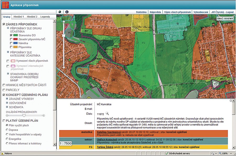
Users can show detailed information about the content of a remark and statements of involved planners.
City Development Authority (Utvar rozvoje hl. m. Prahy [URM]), based in Prague, supplies professional services in development planning, as well as GIS and mapping, for the city administration. The core activities in planning are preparation and maintenance of the citywide planning documents and the analytic materials, as well as strategic planning expert services.
Supporting all activities of public government that depend on map or geographic information, URM is also the municipal center for geographic data collection, processing, administration, and distribution. URM provides a high-accuracy basemap, the Digital Map of Prague; orthoimagery; 3D modeling of the city; and a rich collection of frequently updated thematic datasets (cadastre, utilities, buffer zones, demographic data, transportation, etc.). This GIS data warehouse and these GIS services form an essential platform for all planning activities.
Development Plan for Prague
Development and building activities in the Czech Republic at the local level are regulated by development plans. The core of the development plan is the zoning and spatial regulation map, setting the binding building constraints for each zone type. The scale of Prague's zoning regulation map is 1:10,000. The currently valid development plan has its origin in the mid-1990s and, during its lifetime, has been affected by more than 2,000 minor alterations and several large-scale systemic changes. To reflect the present-day economic and social conditions, opportunities, limits, and development challenges, the municipal assembly decided to provide the new development plan at the end of 2007.
Work on the development plan for a million-resident city is a long-distance run. The guidelines for the new plan were approved in May 2008. In November 2009, a draft of the new development plan was finished for public proceedings. The plan draft, containing 26 thematic maps in scales from 1:10,000 to 1:50,000, covers an area of 500 square kilometers. The draft proposals are elaborated in variants, two for each map. The draft had been presented to the public by an extensive information campaign covering information days, a website, leaflets, announcements in newspapers or public transport areas, etc. The aim of the campaign was to raise general awareness of the development plan and the planning process and promote the unique opportunity to make remarks on and objections to the draft plan.
Remarks and Objections Collection System
After the draft had been finished and published, the one-month period for public remarks and collection of objections took place. This period was the highlight of the draft elaboration, as everyone had a chance to express his or her opinion on the development plan content. The expectation was to collect around 10,000 remarks and objections. To address this wide spectrum of stakeholders, it was decided that the public remarks and objections would be accepted in any form—far beyond the legal requirements: mail, e-mail, and personal entry at the information office. In addition, a special web GIS application form (with interactive maps) was developed for public use. Entries into this form were geolocated and aided city staff to evaluate the results.
At the end of the collection period, 16,000 entries were collected, of which 2,500 were entered directly through the web form, the rest being via the other means of delivery. The degree to which the web form was utilized represents a clear success, considering that this was the first development plan with electronic commenting available in the Czech Republic. All the nondigital remarks and comments were then manually entered by city staff into the same application that the general public used. A PDF scan of each remark was also provided and stored in the database store.
The web entry form was built with ArcGIS API for JavaScript and the PHP application system and based on an Oracle Spatial database (geometry was stored as ST_Geometry data type). The general public could enter its remarks and objections after a simple login into the application system. When the nondigital data was entered afterward, city staff were then able to administer and evaluate this huge volume of geolocated data. Users were allowed to enter point, polyline, and polygon geometries. Registered users could access their entries (locked for further editing after confirming submission) anytime later and download them as PDF documents.
Processing and Evaluation as Web GIS Task
The full power of the application system was revealed during the sorting, study, and evaluation of the collected remarks and objections. Each record was adjusted for the sake of clarifying meaning and to validate spatial location. In many cases, the initial study requirements had to be reworded completely to better reflect the language of development plan regulation. Similar requirements were identified and grouped. Entries with multiple remarks and objections were split into separate items. Also, an overall completeness check of the database was provided—no delivered remark or objection could be missing. This process took nearly six months.
After all entries were adjusted and checked, each remark and objection was examined and assessed in terms of its relevance and how it fit the overall planning conception. The assessment was provided simultaneously from many views: urban structure, zoning regulation, transport, utilities, greenery, environmental impact, etc. This process was facilitated by another special web GIS application derived from the public commenting website. This new application had two main user interfaces: map centered and table centered.
The map interface provided a quick spatial overview of the distribution of entries within the Prague area. The application supported strong search functions (search for entries, addresses, and parcels) and contained a rich collection of basemaps and thematic datasets to concentrate all relevant decision support map materials at one place.
The table interface provided access to the records in the form of well-arranged lists. Entries could be sorted and filtered by many fields: IDs, applicants, type of entry, etc. Information detail on each entry was editable by planning experts until a final statement on how the remark or objection would be handled was negotiated. Both map and table interfaces are cross-linked.
For consequent political negotiations, the application system was enriched with PDF report generation functionality. Development plan remark and objection assessment was finished at the end of 2011.
Conclusion
The development of an application system for the collection and further processing of remarks and objections has proved to be the only feasible way to handle the enormous number of entries. ArcGIS API for JavaScript, together with PHP, provided a reliable, flexible, and easy-to-use platform. During the collection period, users recorded no critical problem with user-friendliness or general performance. The assessment period has been followed by ongoing adjustments and by extending the application functionality together with new needs and requirements of users and planning experts. The success of the project marked the way for the decision to develop a new version of the application system, which should be used in further phases of preparation of planning documentation. The expectation is to optimize the search and general system response performance and provide further improvement of the user interface.
For more information, contact Jiri Ctyroky, Spatial Information Department, Utvar rozvoje hl. m. Prahy (e-mail: ctyroky@urm.mepnet.cz, web: www.urm.cz), or Jan Soucek, ARCDATA PRAHA, s.r.o. (e-mail: jan.soucek@arcdata.cz, web: www.arcdata.cz).