Collaboration Is Easier in Sussex County, New Jersey
ArcGIS Online Facilitates Effortless Data and Map Sharing
Highlights
- ArcGIS Online is a cloud-based, collaborative content management system for maps, applications, data, and other geographic information.
- The county is hosting a map of its common places in Esri's cloud.
- Departments throughout the county are using ArcGIS Online to communicate with each other.
Sussex County, New Jersey, in the northwest corner of the state, is a rural place with 40 miles of the Appalachian Trail, 80 lakes and streams, and historic one-room schoolhouses. Though its character is unique, the county is like most across the United States in its desire to improve communication inside the organization and with partners and citizens.

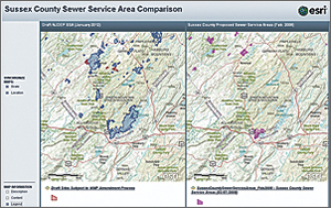
The Sewer Service Area (SSA) application shows proposed areas in 2008 (right) compared with proposed and existing SSAs in January 2012.
Historically, when a county division, such as engineering, wanted to make citizens aware of activities (e.g., road or bridge closures), someone in the division would request a map from the GIS department. Then a PDF of a map, which was often outdated soon after it was created, would be posted on the county website—standard operating procedure for many governments.
When GIS manager David Kunz discovered he could use ArcGIS Online to post current, dynamic maps with information like bridge closures, he began taking advantage of the technology to improve workflows.
"ArcGIS Online provides us with an easy-to-use way to distribute our data out to the public," says Kunz. "They are able to view applications, like our polling place app and the bridge and road closures, so they're able to access information in a way that's easy to understand, up-to-date, and available 24/7."
To create the bridge and road closure application, the GIS department provided a simple database where the engineering staff could input a bridge identifier and status (open or closed, and reason for closure). As information changes, the map service that is published in ArcGIS Online is automatically updated. Adding this feature service to a basemap gives the Board of Elections an internally editable map it can share with the public.
"We wanted to develop tools that allow staff to work independently so they can manage their own GIS data," says Kunz. "Now they don't have to wait for the GIS department to create maps for them—it's automatic."
In addition to improving the speed with which they post geographic information online, departments throughout the county are using ArcGIS Online to communicate with each other. A private group gives them a place to collaborate. Instead of sending data and maps back and forth, group members can share real-time data and comment through the ArcGIS Online group.
"The use of the ArcGIS technology has afforded the county the opportunity to more quickly and effectively address both ongoing and emerging constituent issues," says John Eskilson, county administrator. "The emergency road and bridge closure mapping during Hurricane Irene is a perfect example of how the technology can be used to better communicate with the public. A second but no less important benefit has been to allow ease of access and sharing of data among the many county departments and divisions, saving time and ensuring the common data is used to address issues that cut across departmental boundaries."
Creating Mapping Power
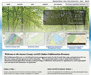
ArcGIS Online is a cloud-based, collaborative content management system for maps, applications, data, and other geographic information. Although Sussex County has GIS servers, Kunz notes that having Esri host maps and applications in the cloud benefits the county.
"We have hardware and our own private cloud," he says. "But with Esri's cloud, we now have the flexibility to choose where we want to host our content."
The county is choosing to host a map of its common places in Esri's cloud. The Sussex County 911 Common Places and Dispatch Zone map allows public safety staff to add location data, such as names of popular businesses, and other well-known places with a valid address.
Members of the sheriff's office and police departments had been submitting this information in Excel spreadsheets and via e-mails requesting that the GIS department geocode them. That workflow created a lag in getting the places identified on a map. When a name changed, it wasn't quickly reflected on the map; public safety staff had to request deletions or changes. Now that public safety staff members have a map on ArcGIS Online, they can update names and post new ones immediately, which is proving to be a tremendous benefit to the municipalities.
"We created a small, easy-to-use editing application built on one of the editor templates in ArcGIS Online, and now they can create or edit existing records in the database," says Kunz. "They know the data better than I do, so they can post it and verify that it's correct."
The Common Places application, which uses Esri's ArcGIS for Local Government Information Model, is generating a single authoritative source for addresses in the county. This source will be used to improve the 9-1-1 dispatch system and support a new paperless inspection application in the health department.
"An advantage of using ArcGIS Online is that it's hands off. I don't have to send data updates; I don't have to be concerned about what the data structures are," says Kunz. "I can just have my service sitting on ArcGIS Online for a department or a municipality to access when they want current data. It's not a copy; it's not a ZIP file; it's our live, current data that people can consume without having to wait for us to send it."
Changing the Way Governments Operate
The Sussex County government has long supported the GIS needs of its municipal partners, since many of them don't have GIS resources. If they do, the resources are limited. Now the county is improving the way it extends its resources to the municipalities.
For Byram Township, the county created a mapping application to show information related to dog ownership, registration, and reported problems. The county health department and public safety staff will also be able to use the application to understand incidents, such as dog bites.
As the Division of Planning updates sewer service areas, municipalities provide critical input. Effectively sharing information on where there is existing infrastructure and the potential for infrastructure in the future is core to the project.
"ArcGIS Online facilitates a good dialog between the county and municipalities in trying to finalize these boundaries," says Kunz. "In the past, we would have used hard-copy maps that would have been distributed to all the municipalities for review and comment. This year, we have one map in one place, and they can review it at their own pace. Unlike the hard-copy maps, they can zoom in to clearly identify where the boundaries should be."
When Kunz looks ahead, he sees the potential to improve data sharing up to the state level.
"A lot of the state's data comes from the counties, so the county GIS program sits in a very unique position to support the local governments, as well as provide the information we obtain from them to the state," says Kunz. "With ArcGIS Online, we are better able to serve the needs of governments at all levels."
For more information, contact David Kunz, GIS manager, County of Sussex (e-mail: dkunz@sussex.nj.us).
