A 3D GIS Solution for Campus Master Planning
Highlights
- ArcGIS and ArcGIS 3D Analyst create a seamless 3D geodatabase of the university campus.
- The 3D solution includes identification with source site plans and as-built drawings available by hyperlink.
- An Esri terrain dataset is used for terrain management.
The University of Rochester (U of R) is a major research university located in Rochester, New York, with approximately 4,600 undergraduate and 3,900 graduate full-time equivalents. The university, along with its affiliated medical center, Strong Memorial Hospital, is the largest employer in the Greater Rochester area and the sixth largest employer in New York State.
Founded in 1850, the university and its medical center have grown dramatically in size. Today, the university continues to expand at a rapid pace, with officials planning to expand at approximately 1,000,000 square feet every decade.
Rapid expansion has led to a complex and often difficult-to-manage matrix of utilities located throughout the university campus. The university has responsibility for domestic water, chilled water, hot water, steam, condensate return, fiber-optic, telephone, natural gas, storm sewer, sanitary sewer, electric distribution, street lighting systems, and medical gases inside the hospital and research complex. None of these utilities follow a traditional right-of-way layout—systems often crisscross each other to form what looks like a complicated underground spider's web. This web of utilities complicates new installations and repairs. Utility excavations are a constant concern.
Since the university includes a medical campus, it is imperative that utility systems function at all times.
To better understand and organize its utility infrastructure, the University of Rochester hired Bergmann Associates, an Esri Partner in Rochester, New York, to develop a solution using ArcGIS Desktop and ArcGIS 3D Analyst. Initial work for the university included georeferencing hundreds of existing utility plans and as-built drawings and converting them into file geodatabase feature classes.
The utilities are in the process of being represented as seamless layers for each system instead of isolated drawings containing multiple systems. This will greatly simplify the internal "call-before-you-dig" process. Instead of sorting through thousands of drawings and trying to mentally edgematch them, employees at Central Utilities will have access to a 3D model of the university with utility systems completely mapped. This solution should enable the university to significantly recoup the previous investment from its library of utility drawings and surveys.
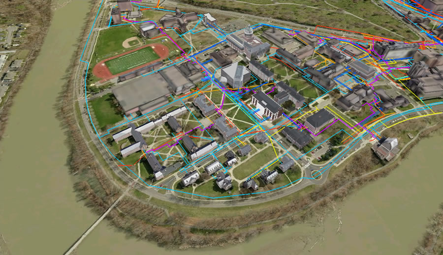
Using ArcGIS 3D Analyst's ArcGlobe software, hundreds of existing utility plans and as-built drawings were georeferenced and converted into file geodatabase feature classes in a seamless layer for each system, greatly simplifying the internal "call-before-you-dig" process. (Aerial imagery from Pictometry International)
Campus Master Planning
Following the launch of its successful new solution for infrastructure development management and the successful development of the utility GIS layers, the university realized that these new solutions could potentially enable comprehensive campus master planning and enhance decision making, promotions, and fund-raising; furthermore, it recognized that these news solutions could be used in conjunction with the 20-year master plan prepared by Ayers Saint Gross, a Baltimore, Maryland-based architectural firm specializing in academic campus planning and design and adopted by the University Trustees in October 2009. The plan envisions major expansion of the healthcare, research and academic enterprise to include realigning roads and improving expressway access.
To address these needs, Bergmann Associates provided Integrated Design and Management (IDM), a business solution that could accomplish all goals by providing a single, managed 3D GIS virtual campus database.
The U of R IDM Virtual Campus has three main components:
- An enhanced lidar terrain dataset
- High-resolution aerial photography
- High-detail, high-resolution structure models
For terrain management, Bergmann utilized an Esri terrain dataset. The dataset was built as a hybrid model, using smoothed lidar masspoints enhanced with surveyed elevations and breaklines. This allows the capture of abrupt elevation changes (such as retaining walls) in a vector format. It also allowed the university to capitalize on its previous survey experience; Bergmann used publicly available lidar and captured survey elevations from previous as-built drawings. The terrain was built with no additional survey or lidar expenditures.
The use of existing survey data allowed Bergmann to correctly model elevation changes (such as loading docks) around the foundation of a structure, providing a high level of site-specific detail that remote mass-collection technologies cannot match.
Draped over the terrain is ultra-high-resolution 4-second/pixel orthoimagery from Esri Partner Pictometry International Corporation of Rochester, New York. The resolution of this orthophotography is high enough that manholes, access points, catch basins, striping, and other assets are clearly visible—giving Bergmann and the university a high degree of confidence in mapping and digitizing. Additionally, the photography serves as an ideal base for the IDM Virtual Campus, visually anchoring the university's building models.
As an architecture and engineering firm, Bergmann Associates has a high level of in-house 3D modeling experience. Industry-leading 3D models and photorealistic renderings are commonly part of its deliverables for architectural or land development projects. Bergmann put that expertise to good use, building extremely detailed structure models for the campus.
Features are stored as a textured multipatch feature class. The high-resolution, photorealistic 3D environment allows planners at the university to see how a proposed building will interact with the existing environment before it is built, ensuring that the size, scale, and style of a proposed building are harmonious with the existing built environment.
The goal of the university is to enable the user to easily view all available floor plans for a structure by identifying it in ArcGIS 3D Analyst and choosing a hyperlink to the appropriate plan. Additionally, the source site plans and as-built drawings for the utility system would be available via embedded hyperlinks.
On the Horizon
The entire campus master plan is being integrated into the 3D model as a time-enabled 3D feature class. The user will have a time slider that will move the model forward through time, showing the plan phasing—building demolition and construction, roadway realignments, growth of landscaping, etc. This is an extremely powerful visualization and planning tool, remarkably effective at presenting complicated three-dimensional and time-phased information.
The University of Rochester has made a major investment into Esri 3D GIS technology and has begun to build a 3D virtual campus that not only models the existing built environment but also looks into the future. It has given the university the capability to centralize campus maps, plans, and planning content. Further, it has the ability to reduce information silos and improved data access for future development planning and review. Using Esri software as the foundation for a 3D campus master-planning tool, Bergmann Associates and the University of Rochester are helping pioneer the usage of 3D GIS-based solutions for campus planning.
For more information, contact Sharon Dickman, spokeswoman, University of Rochester (e-mail: sdickman@rochester.edu, tel.: 585-275-4128) or Andrew J. Raus, principal planner, Bergmann Associates (araus@bergmannpc.com).