Summer 2008
Summer 2008 |
|||||||
|
|
|||||||
The National Geospatial Advisory Committee: An Action Agenda |
||||||
|
By Anne Hale Miglarese, NGAC Chairperson In January of 2008, U.S. Secretary of the Interior Dirk Kempthorne announced the formation and membership of the National Geospatial Advisory Committee (NGAC). This announcement came as no surprise to geospatial professionals following the activities of the Federal Geographic Data Committee (FGDC) or spatial data development and coordination in the United States. In fact, for years, many nonfederal organizations and individuals have called for a voice to officially provide input into U.S. federal government activities related to geospatial programs. For the most part, the federal government was quite willing to receive informal input and hold forums to discuss its spatial activities, but listening was often an ad hoc and casual process. In defense of the government staff, federal law restricts the influence of nonfederal individuals on official federal programs and activities. Their informal approach was the only approach legally possible without setting up what is known as a federal advisory committee under the authority of the Federal Advisory Committee Act (FACA).
But, by formally establishing this FACA committee, i.e., the NGAC, the federal government can now receive formal advice and recommendations from representatives of state, local, regional, and tribal governments, as well as academia and the private sector. The pending establishment of the NGAC was published in the Federal Register on May 16, 2007, along with a request for applications for committee membership. Thus, on January 29, 2008, the secretary officially named 28 individuals to serve on the NGAC (see table at the bottom of this page). These members represent a very diverse and exceptionally talented group of professionals who have spent many years devoted to promoting and advancing the use of GIS technology to improve decision making across many disciplines. GovernanceThe charter for the committee was established by the office of the Secretary of the Interior and establishes that the committee will report to the chair of the FGDC, which is the Secretary of the Interior or his designee. Jim Cason, the Associate Deputy Secretary of the Interior, serves as the chair of the FGDC. The scope and objectives of the committee are also laid out in the charter: "The committee will provide advice and recommendations related to management of federal and national geospatial programs, the development of the National Spatial Data Infrastructure [NSDI] and the implementation of Office of Management and Budget [OMB] Circular A-16 and Executive Order 12906. The committee will review and comment on geospatial policy and management issues and will provide a forum to convey views representative of nonfederal stakeholders in the geospatial community." The committee will meet three to four times per year, and all meetings of the committee will be open to the public, with time devoted on the agenda for public comment. The chair of the NGAC, in consultation with the designated federal official (Ivan Deloach, Staff Director of the FGDC), will set the agenda and meeting dates. All meetings are announced in the Federal Register, and all documents and minutes of the meeting are publicly available on the Web (www.fgdc.gov/ngac). Direction and Guidance from the FGDC ChairpersonThe committee's first full public meeting occurred April 15�16, 2008, in Washington, D.C. At this meeting, Cason formally requested that the committee provide advice on
At this meeting, the committee received briefings from federal staff on several general activities, such as an overview of FGDC activities; a general introduction to the Geospatial Line of Business activity and OMB Circular A-16; and an introduction to the National Map, Imagery for the Nation, Elevation for the Nation, and Geospatial One-Stop. Additionally, significant time was spent allowing each member of the committee to express their views, concerns, and passions related to the work of the committee. From this three-hour discussion, many similarities emerged, and the cohesion of the group began. Getting Started: An Action AgendaThe committee has been a long time in the making and hopes its efforts are not judged by the impact it makes in the first few months but by the quality of the advice and guidance it provides to the chair of the FGDC in the years to come. It is anticipated that the committee will focus on a wide range of topics over the next two years. Many of these issues and subjects may be studied and reported in short order. Many will take more time, and several should be viewed as long-term projects requiring detailed analysis and discussion. Agenda items raised as actions in the first meeting were assigned to subcommittees, then brought back to the full committee for its endorsement in the June meeting. One such item was the creation of a mission statement:
NGAC Endorsement of Imagery for the NationWith a mission statement complete, the committee was asked by Cason to evaluate and make recommendations on the Imagery for the Nation initiative. After hours of debate, the following statement was endorsed by the NGAC:
The committee looks forward to a regular dialog with the organizations promoting Imagery for the Nation, particularly FGDC. While there are still several issues as delineated above, the committee is confident that by working together it can achieve its common goal. Transition Team White PaperIn the first meeting, a significant amount of dialog revolved around the geospatial community's need to engage in the political process by embracing a new administration in November and working to influence this new leadership to embrace geospatial technology as an investment that underpins the national governance structure and to positively influence hundreds of administrative initiatives to follow. The goal of this project is for a geospatial white paper to be developed for the transition team shortly after the November election. The design of the geospatial white paper will be simple and focus on why geospatial technology matters to the federal government, a few high-profile activities that could be embraced by the new administration, and the location and title of presidentially appointed positions within the federal agencies that have traditionally had significant influence on geospatial policy and technology. The subcommittee will be working over the summer on fully developing the transition paper, and the full committee anticipates finalizing the document at its October meeting.
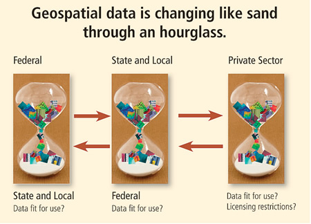
The Changing LandscapeAlso, during the committee's first meeting, there was significant discussion on how the geospatial world has changed dramatically over the past decade and how, as a community, it must acknowledge that change and anticipate the future to make sound recommendations for geospatial investments in the public sector. These changes have occurred at all levels in government, academia, and the private sector. To lay a foundation and context for the NGAC deliberations over the next few years, the committee is developing a changing landscape white paper that describes this change from a technical level, a social level, and a governance standpoint. There are many everyday examples; all one has to do is look at how geospatial technology is being embedded in consumer applications on cell phones to see the change. Perhaps the best example of this fundamental change occurring within the spatial community is to look at the progression of where framework spatial data is generated. In years past, most mapping data was generated at the federal level through federal programs, eventually making its way to state and local governments. However, often, the data was out of date by the time it was distributed to nonfederal governments or, even more typically, was not built to standard scales necessary at the state and local levels. One could argue that about 10 years ago, the hourglass began to turn and the flow of data began to move from state and local government, where the higher-resolution data was procured, to the federal government (see hourglass graphic on page 4). This transition alone has caused serious issues with governance structures that the community grapples with to this day. However, perhaps the most radical assertion of change has just begun. With the influence of Garmin, Google, Microsoft, NAVTEQ, Tele Atlas/TomTom, Yahoo, and many other talented and financially enabled businesses moving into the local search arena on the backbone of geography, it is certain that this is only the beginning of this changing paradigm of where data is created and where partnerships are located.
These fundamental changes and the influence and impact they will have on federal, state, and local governments, as well as the flow of geospatial goods and services, cannot be underestimated. The National Geospatial Advisory Committee will endeavor to describe and analyze many of these phenomena in the white paper to be published later this year. The Long-Term AgendaIn light of the transition occurring within the geospatial industry, the committee spoke at length on the need for a national strategy for building and sustaining the NSDI. There is broad agreement on the need for such a strategy, which is certainly the long pole in the geospatial tent. This effort will take substantial discussion, listening, learning, and debating to be thoughtfully constructed. Deliberations will focus on topics such as the need for strong leadership within federal, state, and local governments. It is ideal that all these entities are represented on the NGAC. Sustainable funding and financing must be a major component of the strategy, and within this topic, the analysis of business models that allow true public-private partnerships will certainly be an interesting debate. Finally, the geospatial community must work together to attract and educate the next generation of this profession. This country's attention to the basic teachings of geography and the many other disciplines that underpin geospatial technology is woefully inadequate. This basic framework for a national strategy for the NSDI will evolve and include building the components of the strategy in consultation with the community at large. Staying in TouchFGDC encourages you to monitor its activities through its Web site (www.fgdc.gov/ngac). The committee is in the process of developing an outreach strategy and hopes to release it on its Web site in the near future. It looks forward to working with the geospatial community to provide actionable recommendations and advice that promote better decision making through geography. About the AuthorAnne Hale Miglarese is a principal with the Booz Allen Hamilton consulting firm in Washington, D.C. Miglarese has worked in state government with the South Carolina Department of Natural Resources and in federal government with the National Oceanic and Atmospheric Administration. Most recently, she was the president and managing director of Fugro EarthData. Miglarese also serves on numerous boards, including the Management Association of Private Photogrammetric Surveyors and TerraGo Technologies. Miglarese is the chairperson of the National Geospatial Advisory Committee.
|