Summer 2008
Summer 2008 |
|||||||
|
|
|||||||
Freeway Mapping Project Highlights GIS Successes Achieved at Agency
GIS Gives Portland, Oregon, Police Bureau Improved Incident Tracking |
|||
Highlights
In the City of Portland, Oregon, the police department has a long history of GIS success. The agency takes a geographic approach to improving operations and services to the community by using GIS for community policing, crime and incident analysis, resource tracking, investigations, and much more.
"Police officers are extremely visual people, and for a lot of the requests, tables and statistical data are sufficient, but when you plot it on a map, it really comes to life," says Christy Khalifa, crime analyst, Portland Police Bureau, Office of Professional Standards. "They're used to dealing with specific areas of the city, and that's the kind of information they need: GIS-based analysis and maps, such as a crime hot spot or trend. That's how effective decisions are made. We're also a bureau that's really driven by the public. So, supporting the public's informational needs with online mapping helps us communicate where crime is taking place and how we're making decisions and matching our efforts with their expectations." Recently, the department further refined and extended its GIS services internally as well as externally to the public by enhancing its records management database with spatially enabled highway data that improves how it tracks incidents along its major highways. In addition, its public Web site now features even greater functionality and ease of use to share a rich array of crime data with the public. Portland Police Bureau Gets GIS Savvy in New WaysThe mission of the Portland Police Bureau (PPB) is to maintain and improve community livability by working with all citizens to preserve life, maintain human rights, protect property, and promote individual responsibility and community commitment. GIS helps the bureau accomplish this mission. The City of Portland, including PPB, is expert in its use of GIS software. An Esri user since 2003, PPB utilizes a GIS platform consisting of ArcGIS software, including ArcIMS technologies for sharing data in a Web browser environment. ArcInfo is used to capture and load data into a central database running ArcSDE technology. The bureau's aggressive GIS practices were demonstrated in 2006 when it hired Khalifa to help expand the GIS and proliferate its use in new ways.
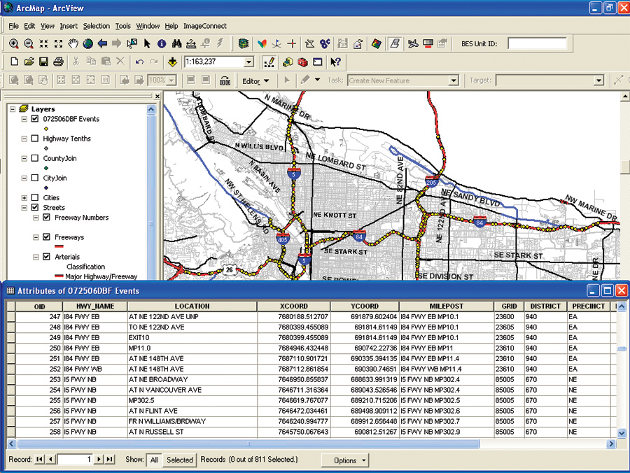
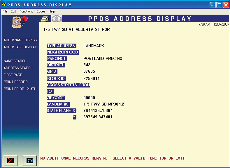
Prior to the Freeway Mapping Project, incidents were mapped to one of five points, with each point representing one of Portland's five major freeways. These were long stretches of city highway that did not provide a clear understanding of exactly where incidents were taking place. The previous method rendered this data useless for detailed crime analysis and mapping purposes, as well as for more wide-reaching policy decisions, such as in which neighborhood, precinct, and/or district to place incidents; where to deploy additional staff; and how to best respond to increased offenses like driving under the influence of intoxicants, speeding citations, or traffic accidents. "Our Portland Police Data System (PPDS), the bureau's mainframe database, was developed in 1984, and it gives us an automated method to store all of our crime data and to analyze it," explains Khalifa. "Since that time, all freeway location incidents within the city of Portland were mapped to one of five points. We recognized that a more accurate system for mapping offenses would ensure spatially correct crime counts and more accurate capture, analysis, and visualization of crime data. This was not possible with previous technology." Collaborative efforts were undertaken by PPB's Information Technology Division, Records Division, Traffic Division, and the Strategic Services Division's Statistical Support Unit to determine the correct format for the data file to be input into PPDS. It was agreed that for purposes of the project, mileposts (to the half mile), on-ramps, off-ramps, overpasses, and underpasses would be the landmarks used, and each landmark would be tied to a pair of x- and y-coordinates. These landmarks were transformed into a GIS layer for mapping purposes and into a spatially coordinated file for inclusion into PPDS. Using an in-car video camera, each landmark was taped for use as a future reference. Spatial analysis methods were used to match each landmark, of which there were more than 1,100 in all, to a spatial location (x,y coordinate) as well as to assign each one to a grid, district, precinct, city, agency, and county. Using a shapefile with Portland's freeway mileposts mapped to a tenth of a mile was determined to be a more practical and efficient option than the physical measurement of each location with a GPS device. The inclusion of such data has improved existing reports and maps produced using mapping software at PPB. For example, many reports produced by PPB rely on the proximity of offenses to defined geographic areas, making for a more accurate analysis with the inclusion of the new data points. Khalifa, along with an officer from the Traffic Division, physically located and identified all "points of access" (on- and off-ramps, over- and underpasses, cross streets, etc.) to the highways and freeways that are within PPB jurisdiction. She then accumulated data and assigned milepost locations to each point of access down to the half mile. Finally, she built a highway/freeway data structure by assigning these milepost locations by precinct, district, and grid. The resulting system helps the bureau more accurately track crime along its major highways and provides commanders and field personnel with better information. Whether capturing data at the scene of a car crash or looking at sets of street data for long-term strategic planning, the improved system has received stellar responses from the many different information stakeholders, including the chief of police for the City of Portland. "Being able to look at crime data by location has always been an important capability for the bureau," says Rosanne M. Sizer, chief of police, Portland City Police Department. "Locating crime data occurring on a freeway has not been possible previously. This problem has been resolved through the extraordinary efforts of our GIS team. PPDS can now support identifying crime locations on our freeways and highways by the precinct, district, and grid." More InformationFor more information, contact Christy Khalifa, crime analyst, Portland Police Bureau, Office of Professional Standards (e-mail: CKhalifa@portlandpolice.org). |