Summer 2008
Summer 2008 |
|||||||
|
|
|||||||
GIS and the GeoWeb |
|
|
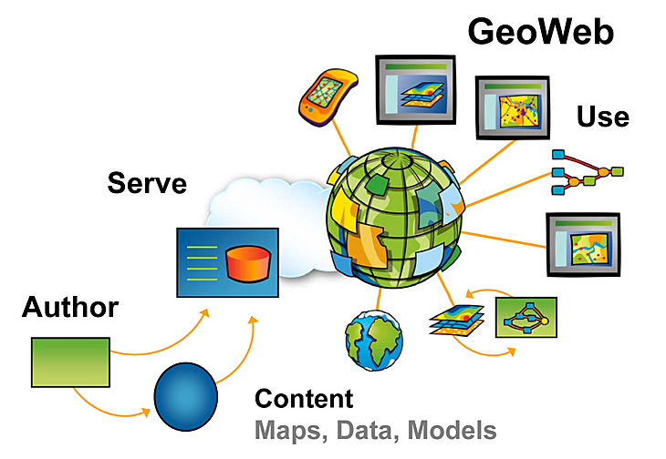
English / Spanish By Jack Dangermond While the first 10 years of Web-based mapping have been very important, the next five will be revolutionary as we move from simple mapping and geospatial visualization to full geoservices on the Web This pattern has already been deployed by Google and Microsoft for supporting consumer map visualization and simple mashups. Google's KML standard (now adopted by the Open Geospatial Consortium, Inc. [OGC]) has provided an easy way for anyone to participate. This phenomenon has led to millions of recorded observations by neo-geographers. While most of this is of little direct value to GIS applications, it nevertheless defines a pattern of sharing geospatial data on the Web that is interesting and promising for growing the GIS community. This year, Esri has taken a major step to integrate its flagship product, ArcGIS Server 9.3, into the Web 2.0 environment. This will allow GIS professionals to directly publish searchable metadata about their services, as well as serve maps, data, and a full range of services for others to view, use, and mash up to create applications. What does this mean? Simply stated, it will mean more opportunities to share geospatial data and consume other services. In terms of functionality and applications, the GeoWeb will move beyond simple mapping and visualization to support integration of full GIS-based services representing "authoritative source" knowledge (maps and data, of course, but also models and complex applications). Users will create new applications built from these services that carry out spatial analysis based on dynamically distributed information. The Rise of Volunteered Geographic InformationThe Web 2.0 world currently recognizes user-generated content (UGC) as a concept that promotes greatly expanded interaction on the Web. Last December, Dr. Michael Goodchild of the University of California, Santa Barbara (UCSB), held a meeting where he introduced the concept of volunteered geographic information (VGI). VGI is basically a new name for georeferenced UGC. The wiki-genre site, Wikimapia, is a good example of VGI. It encourages participants to post comments about georeferenced locations. On Flickr, users can upload photos to latitude/longitude locations, and OpenStreetMap is an international effort to create a free source of map data through the efforts of volunteers using this methodology. While much of the current VGI on the Web represents casual observations or assertions about a place (e.g., the neo-geography phenomenon), conceptually speaking, VGI can also be data collected by traditional authoritative source organizations and agencies and shared openly on the Web. This is basically the GIS concept of spatial data infrastructure (SDI), where multiple organizations share their data and services with each other across the Web. My sense is that we now have the technology platform to begin realizing parts of the SDI vision. We can now do distributed data management and easy GIS services integration. This will support a whole new era of interorganization collaboration. Members of the GIS community will not only learn how to publish and share more sophisticated and useful services, they will also learn how to develop institutional relationships that support collaboration (e.g., utilities serving their maps to local government and vice versa). This initiative will require good relationships and a collaborative culture. Consumer Geospatial Technologies Provide Opportunities for Sharing MapsWhile the Web mapping/visualization tools developed by Google and Microsoft provide very fast, easy-to-access views of images and maps, they are not suited for the more complex work performed by GIS (data management, analysis, workflows, custom applications, etc.). However, the pervasive use of these new environments offers an opportunity for GIS organizations to share some aspects of their work for open viewing by everyone. Of particular interest are Web pages that tell stories about events, situations, forecasts, etc. ArcGIS Server 9.3 can directly serve maps from authoritative sources into the consumer viewers. ArcGIS 9.3 has new technologies that facilitate easy integration with the Web 2.0 environment. They include
These four capabilities allow ArcGIS Server to effectively integrate with the GeoWeb. More Support for StandardsArcGIS 9.3 includes expanded support for OGC standards, such as Web Coverage Service (WCS), Transactional Web Feature Service (WFS-T), and Styled Layer Descriptor (SLD), to provide more open and flexible solutions for the OGC Web Map Service. These services complement the JavaScript, REST, and Flex APIs that allow mashups of Web services. Beyond 9.3, we are engineering methods and tools into our server technology that help organize and structure the less formal VGI, which will enable many more possibilities. Enterprise Web ServicesOf greater importance for many users is the fact that the concepts and standards of Web services and service-oriented architecture (SOA) are also providing a new platform for implementing GIS in the enterprise. The centerpiece of this new environment is the GIS server, which is increasingly being used to serve data, analytic models, and maps for use across organizations. Services represent a new and powerful way to share information and collaborate in its use. The mashup style for building applications will be very popular, not only for integrating distributed GIS services but also for integrating GIS with other IT applications across the enterprise. Esri's technology continues to evolve with a particular emphasis on server technology and Web-based services. The server platform allows the user to easily share applications, data, and knowledge with colleagues in other departments and organizations via the Web and simple geobrowsers. Using the SOA model with GIS services, users have begun to integrate their desktop and departmental solutions into implementations that connect many departments. This Web services architecture allows users to both federate their distributed systems as well as integrate GIS and spatial processing with other IT business systems, such as ERP, CRM, and SCADA. While this has been possible for some time, the advent of SOA and simple technologies to integrate these services has made it much easier and promises to greatly expand the GIS market. The Geographic ViewSociety is becoming more familiar with examining its world through geobrowsers closely integrated with search engines. Esri has been evolving its technology so that it makes use of this powerful technology with free clients, such as ArcGIS Explorer and ArcGIS Online, as well as supporting GIS services and consumer geobrowsers. In addition, our server technology supports this new medium and access to Web 2.0 through the geobrowser. We believe the next step is to go beyond the visualization of simple maps and images. GIS servers managed by a host of public and private organizations will be used to provide these expanded services. While a great deal of GIS data will not be served in the open Internet for security, cost, proprietary, and privacy reasons, many topics of great interest to the public—such as crime, natural hazards, land infrastructures, and environmental conditions—will be made available by the GIS community to the general public. GIS professionals and traditional GIS organizations will provide the backbone of this movement. The whole concept of GIS has always been about sharing and integrating geospatial information from many sources. The Web 2.0 and related Web services offer a new and powerful opportunity to share geospatial information and collaborate in its use. |