Summer 2008
Summer 2008 |
|||||||
|
|
|||||||
Esri Collaborates with Adobe to Support Geospatially Referenced PDF Map Files
Adobe Acrobat 9 and PDF Supported in ArcGIS 9.3 |
|||
Highlights
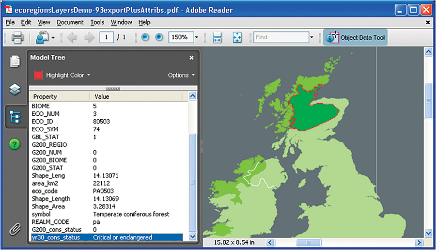
Enhanced support for interactive mapping within PDF is available with the release of ArcGIS 9.3. ArcGIS 9.3 users can author map documents and export both the map image and the related geospatial information to PDF. This makes the PDF map interactive for the recipient. The release of ArcGIS 9.3 is concurrent with the release of Adobe Acrobat 9 and Reader 9 software. Esri and Adobe have been collaborating for the past year on these PDF geospatial capabilities enhancements.
GIS professionals can now widely distribute their map documents in PDF with increased value to the reader, who may otherwise not have access to the existing interactive capabilities present in ArcGIS software. ArcGIS 9.3 users can author a map document and export it in PDF for wide distribution while passing along the ability for increased end-user interaction with the document beyond simple viewing. Recipients of PDF maps can find and display a location in the file using x,y coordinates, as well as measure features directly on the map. This enabling capability both enhances existing customer workflows and creates new ones because recipients without ArcGIS can directly interact in new ways with maps using Acrobat 9 or Reader 9. "Our collaborative work with Adobe allows our users to distribute their GIS maps to a wider audience," says Damian Spangrud, senior ArcGIS product manager, Esri. "The portability and pervasiveness of Adobe Reader and Acrobat software allow ArcGIS users to better share their geographic information." Depending on which version of Adobe software is used, recipients will have graduated levels of functionality when interacting with these geoenabled map documents:
"The ability to effectively extend the reach of GIS information is something of great interest to enterprise organizations and government agencies," says Michael Folkers, Acrobat group product manager, Business Productivity Business Unit, Adobe. "Our work with Esri and the advancements we've made in Acrobat 9 will enable customers to leverage the richness of PDF and the reach of Adobe Reader for GIS workflows." The enhancements supporting PDF in ArcGIS 9.3 are available as a free download patch for ArcGIS Desktop, ArcGIS Server, and ArcGIS Engine. More InformationTo learn more about this new functionality in ArcGIS 9.3, visit www.esri.com/whatsnew. |