Spring 2004
Spring 2004 |
|||||||
|
|
|||||||
Redlands, California, Students Creating Interactive History GIS CD
Grove High School GIS Club Catalogs City's Heritage |
|||||||
History textbooks can deliver valuable information to students about the past of their countries, states, and regions. However, textbooks seldom provide the details necessary to explore the identity of a specific community. It is sometimes difficult to answer questions about past events that have shaped its present form. Many teachers struggle to teach students about the origin of the buildings, streets, and places of the cities and towns that make up the background of their daily lives. GIS has proven to be a key technology for discovering the past. Historians, archaeologists, and increasingly, students, are using GIS to organize, analyze, and share data relevant to their town's history. Settled in 1881 and incorporated in 1888, Redlands, California, was for almost three-quarters of a century at the heart of the largest navel orange producing region in the world, attracting people from all over the world from the late 1800s to the late 1950s. Numerous documents, pictures, and artifacts held in the Heritage Room of the Redlands Smiley Library provide pieces of the story of how the city has changed. The challenge was to bring this information to the classroom. When Craig Lesh, a Redlands resident and owner of Heritage Education Programs Consulting contacted Grove High School with interest in developing an interactive GIS CD with historical data, the students in the GIS Club eagerly stepped up to the challenge. Lesh and the students hoped to bring a sense of historical identity to the community and local knowledge to Redlands third graders. Although the program is geared toward third grade students, its potential for use as a community resource is also promising. "Redlands is so into preserving the heritage of the community's homes, buildings, and structures," says Lesh, "that many people from the geological, historical, and museum communities are interested in the project. We were able to continue the project this year through Redlands' Historical Society funding." Lesh was prepared to lead the students through their historical discoveries but lacked the GIS knowledge to build the application. Grove High School already had two GIS capable PCs and ArcView 3.x software, which they acquired in 2000 through a technology grant from the Esri education program. Bob Booth, the Esri archaeology solutions manager and documentation writer, volunteers at Grove as a GIS consultant and helped the school switch from ArcView 3.x to ArcGIS. Lesh's historical knowledge easily fused with Booth's GIS expertise as they began to plan the project. Since Redlands' past is rich with orange packinghouses, unique Victorian buildings, and evolving urban developments, it was easy to decide what data to collect.
"The idea was to be able to track the growth of Redlands through the increasing number of schools and citrus facilities," says Booth, "and then show the change from an agriculture-based economy to the present economy. The application also tracks the conversion of the Redlands' orange groves to urban land uses." The GIS Club's freshman and junior students embarked on the journey into the past, collecting pictures of buildings in Redlands from different years over the past century, collecting six historic maps of Redlands from 1890 to the present, and doing archival research on prominent local citizens. They also went out into the community to conduct surveys of the modern businesses in the historic downtown area of the city. To create a framework to integrate all of this information, they downloaded free TIGER street centerline data for the city. "To find the information," says junior Ben Wright, "we referenced old city directories. We went to Redlands' Smiley Library to look through all the city records to find information about when businesses opened, whether they changed addresses, where the streets were located, and other information." Booth taught the students how to use ArcView 8 to georeference the scanned maps of Redlands that they had collected to match the roads. They used the software's query tools on the street data to find the locations of the historic structures in town, using the often incomplete street addresses or intersections listed in the old directories. The students created a georeferenced record of the city's growth over the past 100 years. To obtain packinghouse and school locations, the students did further research in the city library, copying the locations of any schools or packinghouses that were listed in the old city directories for each available year. Booth then showed the students how to use the ArcCatalog application in ArcView to create new shapefiles and add columns to store attributes of various types. After discussing what data to capture about the schools and packinghouses, the students created point shapefiles for each and added attributes to store information such as the name, date established, any new names, and the last recorded mention.
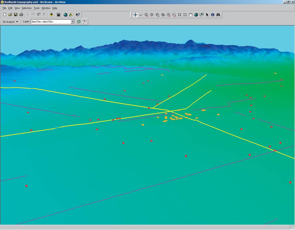
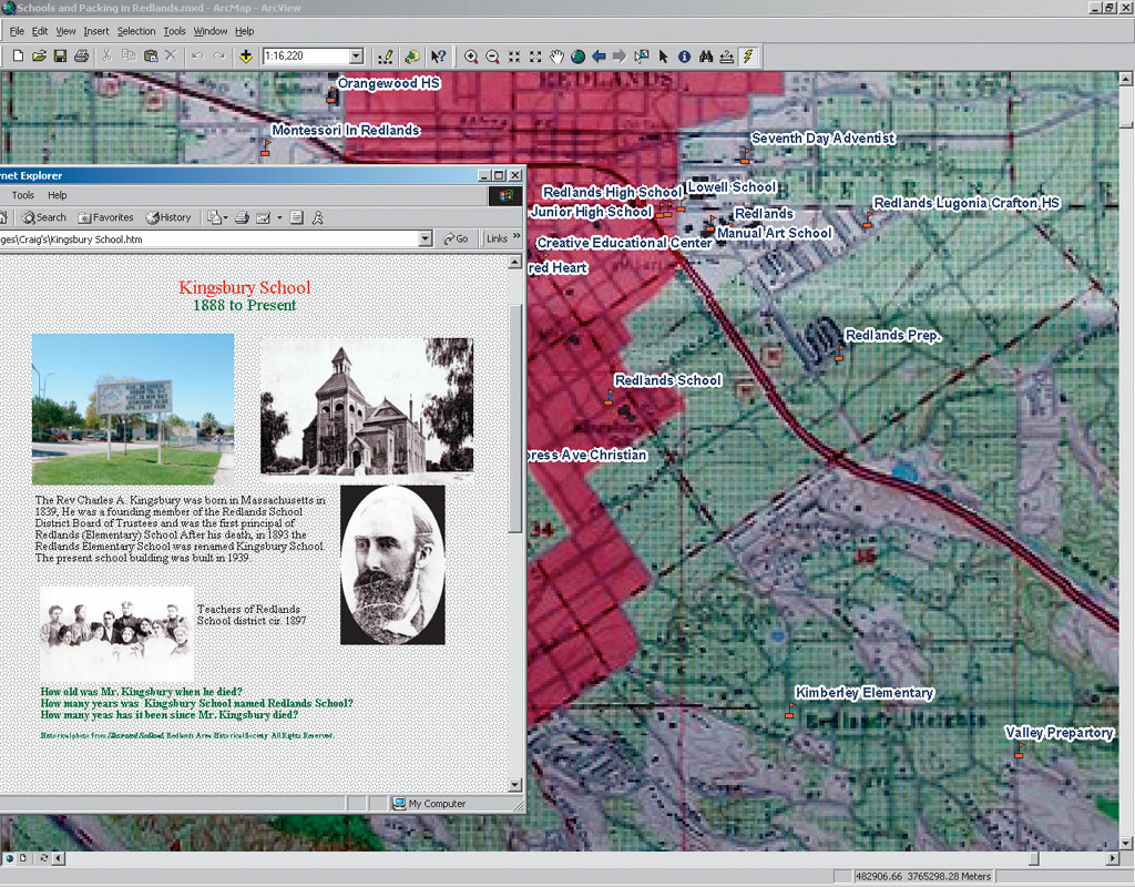
The students went through the directory listings for each year and used Selection by Attribute to find the mentioned streets and their intersections, or they used the Identify tool to look at the street address range attributes to find numeric addresses. Then, in an edit session, they digitized the points into the schools and packinghouse shapefiles and added names and date information to the attribute tables. To reference attributes, such as images and Web pages, Booth led the team through associating hyperlinks to a feature. To produce the links, the students created a polygon shapefile to represent the city blocks on either side of State Street, the main street in Redlands. They digitized the polygons to represent the north and south sides of the street and did a survey of what businesses were on each block today compared to what businesses were there early in the century. With their findings they prepared HTML pages listing the businesses for each block for the present and the past and hyperlinked them to the block features on the map. They also scanned and georeferenced strips of Sanborn fire insurance maps for various blocks that show what types and sizes of buildings were on each block. The students created and hyperlinked Web pages for each of the schools that highlight the history of the school and the origin of its name. They also created line shapefiles for the city's horse drawn and electric trolley lines with an attribute for the line name and years in operation. Then they digitized the routes using existing street features as guides. To illustrate the growth of the city over time, the project also shows the urbanized extent of Redlands over the past century. The students created a polygon shapefile, added a field for the year, and then heads-up digitized the urban areas using four United States Geological Survey quads for the 1890s, 1950s, 1960s, and 1980s that showed urbanized areas and citrus groves in different colors. Each of the decades is represented by a polygon, which shows the expanding urban area and corresponding decline in local citrus production. Although it is not completely integrated into the project yet, Booth also introduced the students to ArcGIS 3D Analyst. The extension's ArcScene application provides the interface for viewing multiple layers of three-dimensional data and for creating and analyzing surfaces. "I showed them how to drape images and GIS features on a digital elevation model in ArcScene," says Booth. "They are very interested in this application and are planning to create a 3D animation showing different layers of the GIS they've built." The project is near completion and will be distributed on CD as an ArcReader project to local elementary schools as early as fall 2004. "The program conveys the idea of Redlands' past and gives it a sense of place," says Lesh. "The textbooks for California have to be generic, so they cannot focus on the community aspect. This program gives the community a resource to gain more knowledge about its area." The students of the Grove High School GIS Club gratefully acknowledge DigitalGlobe, Inc.; the National Geographic Society; and Pixxures, Inc. for donating imagery for background display. For more information about the Grove High School history project, contact Craig Lesh (e-mail: crlesh@heritageedu.com). |