The Future of Urban Design
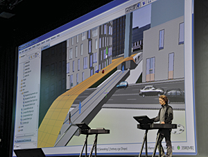
Creating a pedestrian bridge in CityEngine at the Esri User Conference Plenary Session in July 2011.
Those who attended the Plenary Session at the Esri International User Conference in San Diego, California, this year saw Jack Dangermond announce the acquisition of an innovative company called Procedural. Its CityEngine product makes it easy to create high-quality 3D content using nothing more than a combination of 2D data, attributes, and procedurally defined rules. This means that any GIS organization will be able to create visually stunning 3D urban environments using the data it already has.
This is an exciting new capability for many GIS users, and the upcoming release of CityEngine is designed to tighten the link between GIS and 3D urban landscapes even further. However, the fact remains that CityEngine is aimed more at professionals in 3D content creation than at everyday GIS users. Urban planners, in particular, actually need a combination of the best elements of CityEngine (rule-based, high-end 3D content creation) and the best elements of ArcGIS (data management, analysis, and sharing), all made available in a workflow-based solution. Esri started work on a new solution to meet this need.
The primary goal of this new solution is to make it simple to visualize, design, and understand urban environments, especially as cities explore more vertical solutions for people to live and work within. This new application will allow users to experiment with internal designs, proposals from developers, and even fundamental zoning laws (like maximum building heights and offsets) and get immediate visual and analytic feedback regarding the impact of these decisions. For example, approving a proposed high-rise development could impact many existing residents with increased shadows or reduced views. Or, changing zoning laws to increase the maximum building height could result in more residents than the current road or sewer network could handle. Designing urban environments, especially in the higher-density cities of the future, is a complex and critical problem GIS can help solve.
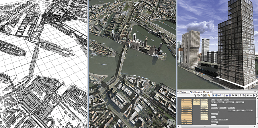
These 2D and 3D views of an urban proposal were generated from the same GIS data.
To remain as easy to use as possible, this solution will leverage two other Esri initiatives—templates and GeoDesign.
Applications that integrate with Esri's templates, such as the Local Government template, are "smarter" because they know which features and feature attributes to expect from the data. They also have information about how to symbolize and render the data and often even have access to rules about how to create and maintain valid GIS data. This knowledge empowers an application to automatically configure itself to work in an optimized manner while still remaining extensible. The new solution will have this advantage, meaning that it will be plug and play for many existing ArcGIS users and will only need an initial configuration phase for those with a more customized geodatabase design.
GeoDesign is another concept that will play a crucial role in the development process. The fundamental idea behind Esri's GeoDesign initiative is that designing is an iterative process. That is, by incrementally designing, evaluating, and comparing designs, planners from all industries can have confidence that their blueprints for the future are the best possible. GeoDesign also implies a workflow to the GIS process, from gathering data, defining goals, and creating alternative solutions to the final analysis, reports, and presentations of the designs attempted. Urban planners make up one group of people who can benefit from using this pattern, and the new solution will make the process seamlessly available to them.
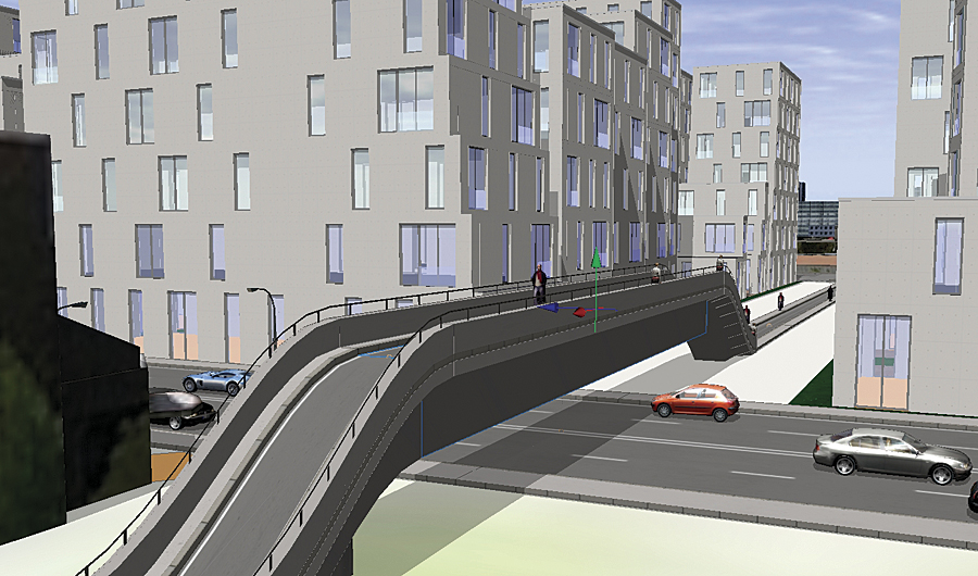
This pedestrian bridge was generated using CityEngine.
This solution will also be about sharing urban plans with others. The release of ArcGIS 10 demonstrated Esri's commitment to making it easier to share GIS content, both within an organization or with large audiences through the cloud.
To be clear, there's still a fair way to go for this solution. There are a lot of decisions to be made along the way, but many of the pieces needed are already in place, and Esri's development team—including the talented additional pool of people coming from Procedural—are champing at the bit to make the design of 3D urban areas easier and more effective than ever before. Look for more news on this new solution in 2012.
To learn more about ArcGIS 3D capabilities, visit esri.com/3d.
To learn more about CityEngine, visit esri.com/cityengine.
To learn more about Esri's GeoDesign initiative, visit esri.com/geodesign.
To learn more about the ArcGIS Local Government Template Initiative, visit resources.arcgis.com/content/local-government/about.