Abu Dhabi Police Creates GIS Center for Security
UAE Capital on the Road to a World-Class Enterprise GIS
Highlights
- ArcGIS supports all phases of police service, including emergency field management and command and control.
- The GIS Center for Security section was created to handle GIS data and applications for all the police departments.
- The GIS-based software provides contingency plans and brings together data and processes from multiple applications.
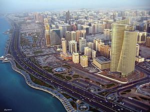
Abu Dhabi is one of the seven emirates that comprise the United Arab Emirates (UAE) and is the capital. Like Manhattan in New York City—and having a similar skyline—Abu Dhabi is located on an island off the coast of the Arabian Peninsula. What was once a coastal town is now a sophisticated international metropolis where trees and parks are prominent. This city's extraordinarily fast development has naturally led to typical urban concerns, for example, fighting crime and providing safer communities, which are global challenges as well.
For Abu Dhabi Police (ADP), one of the main pillars for enhancing public confidence in the police and its services to citizens and visitors is information. The force uses GIS to bring together people and processes for making better decisions.
Police headquarters in Abu Dhabi operates with other UAE police forces through the Ministry of Interior to achieve a safer society. Abu Dhabi Police serves and secures four major districts: Abu Dhabi island, Al-Ain City, the external region, and the western region. ADP units include police patrol, emergency response, crime investigation, and traffic, as well as other specialties. The goal of Abu Dhabi Police is to become an intelligence-led, proactive police force that responds to the needs of society with the highest level of integrity and training.
Development
As directed by the vision of His Highness Sheikh Saif Bin Zayed Al Nahyan, Minister of Interior, over the period of two years, Abu Dhabi Police visited law enforcement agencies around the world, including agencies in Singapore, the United States, Japan, France, Germany, Finland, the United Kingdom, and Australia, to observe and compare how they use GIS for crime geoanalysis, public safety, protection, police investigations, and crisis and disaster management, as well as other purposes, including mission-critical operations.
The result was a comprehensive and ambitious vision to implement an enterprise GIS system that serves the emirate of Abu Dhabi and could be deployed and used by all UAE police and public safety forces. ADP was convinced that ArcGIS would be ideal to build a modern GIS-enabled system that would support all parts of police service, including emergency field management, GIS task force management, command and control, and automatic vehicle location.
"ADP realized that geolocation and spatial capabilities are central to all aspects of police business and align with its strategic goals," says Maj. Gen. Ahmed Nasser Al Raisi, general director of central operations and champion of the GIS program for security in the UAE.
With this idea as its starting point, the GIS Center for Security (GISCS) section was created and is responsible for handling GIS data and applications for all ADP and emergency departments.
"A goal of the GIS Center for Security was to find an efficient method for bringing together information and analysis quickly and easily for the people who need it," says 1st Lt. Mohammed Saleh Almansoori, head of GIS Center for Security.
Challenges included locating the right maps, finding the closest and right police resources to respond to an emergency crisis, and sharing all information with other concerned police departments and multiple disaster teams.
"Historically, departments produced maps by manually combining data from separate databases to generate reports about emergency events," says Lt. Col. Nasser Sulaiman Al Maskari, command and control room head in Abu Dhabi Police and manager of Effective Response Strategic Goal. "The reports contained map data, such as incident location, location of some assets, locations of responders, points of interest, and more."

Abu Dhabi is the capital city of the United Arab Emirates, requiring a technology-savvy police department.
GIS solutions architect Mohamed Bisher Bashaireh, Abu Dhabi Police, adds, "ADP used to generate separate reports from a variety of police legacy systems, manually compare all the spreadsheet and map reports, and try to develop actionable information from them. This process took a long time."
To overcome these manual data challenges, GISCS implemented EmerGeo Fusionpoint software from Esri Partner EmerGeo Solutions, Inc., of Vancouver, British Columbia, Canada. EmerGeo Fusionpoint is tightly integrated with the central GIS database served by ArcGIS for Server. In addition, GISCS's crisis information management system includes software based on ArcGIS to integrate five legacy systems:
- Command and control system for high-priority crimes
- Automated vehicle location for monitoring crisis vehicles
- Closed-circuit TV cameras for viewing live feeds around the city
- Contingency and security plans for large-scale event and disaster planning
- Human resources system for viewing specialized personnel information for deployment
In support of this ambitious vision, ADP also worked with EMC Corporation of Hopkinton, Massachusetts, to complete a state-of-the-art design of a police GIS virtual secured cloud. EMC, in turn, brought in VMware, Inc. (of Palo Alto, California), to provide an infrastructure that is secure, scalable, and available for an uninterrupted critical business that operates around the clock.
"GIS Center for Security identified the importance of a nationwide solution," says Nasser Al Raisi, "that would be used to enhance community safety and public security, which led ADP to invest in a federal security project aiming to leverage data sharing between the various ADP departments and concerned federal government partners."
Current Success
The first phase of the vision has become a reality: a world-class emergency management system is now used by both the police and emergency departments. The system has led to better information integration and use by staff who previously worked with multiple, separate information systems.
The new system can be used during large-scale natural disasters, as well as other events both major and minor, such as earthquakes, large industrial fires, and riots. It supports all phases of emergency management, including assessing risks, mitigation, response, and recovery. The system also enables careful evaluation after a major incident has occurred by integrating data using the map common operational picture (COP) to analyze the effectiveness of the agency's response—taking advantage of nonpolicing GIS data from ADP partners and police forces across the UAE.
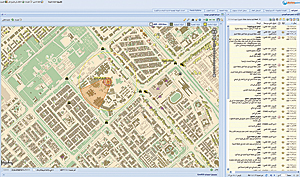
GIS-based software provides contingency plans and automatically brings together data and processes from multiple emergency and nonemergency applications. The software delivers a single unified view—the COP—of critical operational data to those who need it.
Future Growth
This secure infrastructure will be the foundation of all future projects at Abu Dhabi Police and other police forces throughout the UAE. The Policing Operations Directorate of Abu Dhabi Police, along with GIS Center for Security, is currently evaluating a strategic project aimed for police task force management (TFM) to enhance response time and resource planning. This major project will enable various system users and decision makers to visualize data, ensuring efficient and effective resource allocation and utilization.
Says Mohamed Termah Abdul Rahim, GIS infrastructure architect and project manager of the GIS TFM project of Abu Dhabi Police, "The future implementation will take advantage of the already-designed, secured cloud environment."
For more information, contact 1st Lt. Mohammed Saleh Al Mansoori, head of GIS Center for Security, ADP (e-mail: malmansouri@adpolice.gov.ae).
