ArcNews Online
Fall 2010
[an error occurred while processing this directive]National Park Service Follows the Modern Lewis and Clark Trail
Historic Trail Auto Route Road Signs Inventoried with GIS and GPS
By William J. Gribb, Geography Department, University of Wyoming
Highlights
- Using ArcGIS Desktop analytic capabilities, NPS examined the clustering of route signs at road intersections.
- To provide one consistent road base file, the StreetMap dataset was incorporated into the project.
- The digital imagery of the signs provided a mechanism to assess road sign repairs without going into the field.
![]() The courage, determination, and adventure of the Lewis and Clark Corps of Discovery have inspired many to follow its pathway, just not in the same arduous way. Congress recognized the importance of preserving the historic and nation-building significance of the Lewis and Clark Corps of Discovery journey. In a series of legislative actions, Congress created the Lewis and Clark National Historic Trail, an auto route that follows as closely as possible the water route that the Corps of Discovery traveled in 1804–1806. The 11 states, which Lewis and Clark traversed, designated roads that parallel the actual route taken as the auto route roads. The National Park Service (NPS) worked with the individual states and made available the official signage designating the auto route. Lewis and Clark followed one route on their westward journey and slightly different routes on their eastward return journey, thus creating routes that can be followed with several different roads representing the westbound and eastbound pathways.
The courage, determination, and adventure of the Lewis and Clark Corps of Discovery have inspired many to follow its pathway, just not in the same arduous way. Congress recognized the importance of preserving the historic and nation-building significance of the Lewis and Clark Corps of Discovery journey. In a series of legislative actions, Congress created the Lewis and Clark National Historic Trail, an auto route that follows as closely as possible the water route that the Corps of Discovery traveled in 1804–1806. The 11 states, which Lewis and Clark traversed, designated roads that parallel the actual route taken as the auto route roads. The National Park Service (NPS) worked with the individual states and made available the official signage designating the auto route. Lewis and Clark followed one route on their westward journey and slightly different routes on their eastward return journey, thus creating routes that can be followed with several different roads representing the westbound and eastbound pathways.
In an effort to update, integrate, and computerize the auto route and signage, as well as link the auto route to significant historic, cultural, and landscape features, the National Park Service's Lewis and Clark National Historic Trail group formed a partnership with the Wyoming Geographic Information Science Center (WyGISC) at the University of Wyoming to create a GIS database. The objectives of the project were to construct an accurate location of the auto route; locate and inventory existing Lewis and Clark auto route signs; locate and categorize the significant historic, cultural, and landscape features in close proximity to the auto route; and assess the way-finding capabilities of existing signage. To meet these objectives and create a database that integrates with the current NPS GIS configuration, a combination of ArcGIS Desktop, Wind Image software, and Trimble's Pathfinder Office was used.
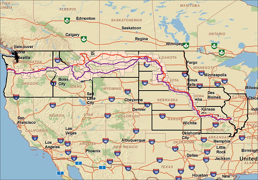
The Lewis and Clark National Historic Trail auto route extends from the plains to the Pacific.
Working with the Lewis and Clark NPS group, the WyGISC team identified initial U.S. Geological Survey 1:100,000-scale digital line graph databases that could be incorporated to provide the initial road and hydrology datasets. Census Bureau TIGER files were included for state and county boundaries and the location of the 1,431 places, towns, and cities the auto route crosses. Four states had already produced accurate ArcGIS Desktop compatible shapefiles; the remaining seven states provided only hard-copy maps of the auto route. In the effort to provide one consistent road base file, the Esri StreetMap dataset was incorporated into the project and the auto route layer adjusted to it. The project objective, however, was to locate and inventory the road signs designating the route and signs directing travelers along the route. To accomplish this objective, the team completed a combination of location and data coding using Trimble Pathfinder Pro XRS receivers with data logger and a Ricoh Caplio 500SE GPS camera. The location of each sign was recorded with the XRS unit along with 13 characteristics of the sign, including number and condition of panels, and road characteristics. In addition, the team captured high-resolution digital images of the sign and the surrounding landscape with the Ricoh camera. To assist NPS with integrating the auto route with significant cultural, historic, and landscape features complementary to the Lewis and Clark journey, a total of 607 sites were also recorded using the GPS and digital images.
After 42 days of field data collection, the team needed several months to edit the data and create a system to integrate the auto route with the corrected sign locations and the digital images. With Visual Basic for Applications, a script was developed that created an identification system that linked the sign to the digital image using a combination of route designation, date, and time. This ID system allows NPS researchers to select a sign along the auto route and access the attribute database about the sign, its location, and condition and the digital images of the sign. The same potential is available for all the cultural/historic/landscape sites along the route. Overall, researchers will have access to 1,817 signs, 607 sites, and 10,295 images along the 6,885 miles (11,080 km) of the Lewis and Clark National Historic Trail auto route.
As part of the field collection data, the team captured the types of signs and their conditions and effectiveness characteristics. This allows NPS to not only create descriptive information about all the signs but also provide the ability to query and produce maps of the location of signs based on any of the attributes. For instance, NPS can now determine which signs need repair or maintenance because of vandalism or excessive wear or which signs are obstructed by vegetation overgrowth or some other barrier. This information provides a very cost-efficient means to determine the number of signs needing repair and their location so the appropriate repair teams can schedule the needed action. The digital imagery of the signs provides a mechanism to assess the repairs without going into the field.
As part of the project, NPS wanted the capability to examine and assess the distribution of the auto route signs. Using ArcGIS Desktop analytic capabilities, the clustering of route signs at road intersections and route turns can be examined to determine if the correct combination of signs, densities, and distances is available to direct the traveler along the auto route. In addition, the ability to view the digital images allows NPS staff to assess the signage along the route at potentially hazardous locations.
About the Author
William Gribb, Ph.D., is an associate professor and director of the Graduate Program in Planning at the University of Wyoming and an affiliate researcher at the university's Geographic Information Science Center.
More Information
For more information, contact Neal Bedlan, outdoor recreation planner, Lewis and Clark National Historic Trail (e-mail: neal_bedlan@nps.gov), or visit the Lewis and Clark National Historic Trail Headquarters site at www.nps.gov/lecl/index.htm. Key personnel for this project at the University of Wyoming's Wyoming Geographic Information Science Center were William J. Gribb (e-mail: planning@uwyo.edu), Scott Lieske (e-mail: lieske@uwyo.edu), and Phil Polzer (e-mail: ppolzer@uwyo.edu).