Fall 2008
Fall 2008 |
|||||||
|
|
|||||||
Ghana Project Leverages GIS-Based Title Registration and Microfinance to Alleviate Poverty |
|||||||
|
By Peter Rabley, International Land Systems, Inc. Highlights
This article is part one of a multipart series. Read Part 2 of this series. A pilot project under way in the African nation of Ghana seeks to demonstrate the vital role that formalization of landownership can play in helping the poor take a crucial first step away from poverty. Focused on one of the poorest areas in the capital city of Accra, the pilot is leveraging the latest geospatial technologies to create a land titling process and GIS-based land records system where neither existed in the past.
Impetus for the Ghana pilot comes from the Clinton Global Initiative (CGI), started by former U.S. president Bill Clinton to challenge some of the world's leading organizations and individuals to make commitments that positively impact global health, poverty, climate change, and education. Accepting the CGI challenge to work toward alleviating poverty was First American Corp., a major title insurance and real estate information provider based in Santa Ana, California. With an extensive background in land titling, Craig DeRoy, then president of First American, embraced the economic theories described by Dr. Hernando de Soto in his acclaimed book The Mystery of Capital. The Peruvian economist is among the first to identify and describe the relationship between the formal recognition of property rights and the fight against poverty. DeRoy saw the CGI challenge as an opportunity to put de Soto's ideas into action. With several partners, DeRoy presented the concept of a pilot project to the United Nations Commission on the Legal Empowerment of the Poor, which seeks to "make legal protection and economic opportunity not the privilege of the few but the right of all." The project received immediate feedback and encouragement from the commission's cochairpersons, Madeleine Albright and de Soto. "Government recognition of landownership [through land titling] gives the poor an identity, which yields numerous benefits," says DeRoy. "The land title can ultimately be used as an asset to leverage permanent change in their economic and financial futures." According to de Soto, poor people almost everywhere in the world have one thing in common—the only asset they have is the land they occupy. Unfortunately, very few of these people have ever received any type of legal recognition that the land is theirs, especially in situations where the ownership is informal or based on customary forms of tenure. Without a registered deed, title, or lease, the owner cannot leverage the land as collateral to take out a loan that might be used to start a business or improve the property.
From an economic perspective, this untitled land represents trapped capital that could be accessed to stimulate the local financial market with microfinance loans and mortgages. But gaining access to this hidden capital requires the landowners to have formal titles or deeds to their properties. De Soto's research revealed that the benefits of formal landownership extend beyond the monetary value of loans and mortgages and provide another crucial stepping-stone out of the hopelessness of poverty. A land title gives a person an address, often for the first time, which dramatically improves that individual's sense of identity. As a result, the impoverished enjoy a greater feeling of security that their land won't be taken away and that they can improve the property. People with land titles are more likely to put their children in local schools and demand basic services from the government. Despite these benefits, land titling and registration are out of reach for most of the poor. The process itself may be too daunting for governments to implement in poverty-stricken areas where no property mapping has ever occurred. And even in countries where titles and deeds do exist, the procedure may be too complicated, expensive, and time-consuming for low-income people to consider. As a result, the capital remains locked in the land, the local economy suffers, and the poor have no way out of their poverty. Assembling the TeamFirst American and CGI clearly understood the benefits of land titling and in 2006 agreed on a commitment for the U.S. company to develop a template for cost-effective, in-country creation and maintenance of a land record system that ensures a means for establishing and holding the legal title to a property. To lead this project beyond the original commitment, DeRoy took early retirement and formed a new company called Corporate Initiatives Development Group (CIDG). "In creating the land record template, the challenge was not in developing it, but in actually implementing it and making it practical," says DeRoy. "There had been much historic debate on the effects of formalizing landownership for the poor, but little had been done to bring these theories to market. I believed it could be done if the right individuals and companies could be engaged, leveraging years of experience and intelligence in land and technology issues to put together a process that could be made simple." He sought to extend the CGI commitment to include an in-country pilot implementation. To make the pilot a reality, CIDG assembled a team consisting of International Land Systems, Inc. (ILS), Opportunity International, Trimble Navigation, and Esri. Each provides a capability vital to the development of a practical land record system:
Selection of Opportunity International as a partner in the pilot highlights the important role that microfinance can play in the alleviation of poverty through formalized land titling. Historically, microfinance has focused on lending relatively small amounts of money—$50�$500—to individuals for use in starting in-home businesses. A sewing machine, for instance, can allow a woman to make and sell clothing in her neighborhood. Usually based on short-term paybacks, these loans are often made in trust groups so that peer pressure, not collateral, is the incentive for repayment. The result is a repayment rate of more than 95 percent on microfinance loans worldwide. "Microfinance brings capital to these emerging markets in a very responsible way," explains DeRoy. "The creation of micro-entrepreneurs is a proven approach to the transformation of entire communities. In our project, we move microfinance one step further by placing Opportunity International, the microfinance lender, into the position of acting as a trusted broker for its clients seeking land registration. This use of the private sector serves to initiate, simplify, and accelerate a process that is often stymied by overwhelming governmental procedures and bureaucracy." In recent years, microfinance lenders have been looking to expand their reach by loaning larger amounts of money for a variety of uses beyond entrepreneurial business, but this type of lending often requires an asset to be offered as collateral. More often than not, these lenders experience the other side of the situation described by de Soto. They want to loan money to the poor, but the only asset is untitled land, which can't be used to secure the transaction. This oft-repeated scenario provided Opportunity International an incentive to facilitate land titling as a means of growing the potential market for its microfinance product offerings. Targeting Ghana's Schools
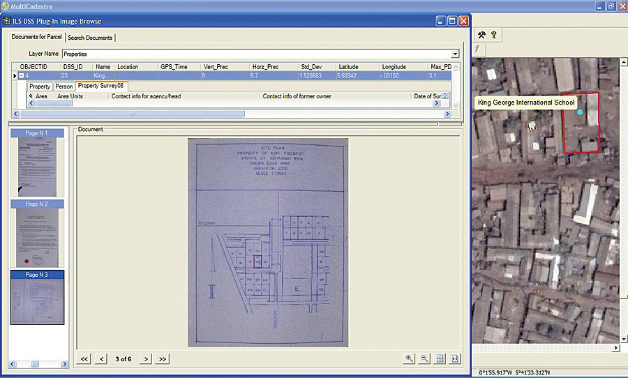
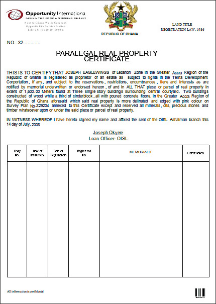
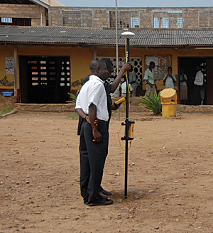
In 2007, the participants chose a very poor area known as Ashaiman on the outskirts of Accra, Ghana, as the pilot location. Ashaiman is home to about 400,000 people in a 40-square-kilometer region where most of the structures can best be described as shacks and shanties. It was considered ideal for the pilot because Opportunity International is actively involved in microfinance there and had already been considering developing loan programs for the hundreds of private schools located in the area. Operation of private schools is a growing business in Ghana, and the owners are seeking funds to build additional facilities and accommodate more students. From a mapping perspective, the schools were appealing for the pilot because the boundaries of their land are usually well defined. The decision was made to target only private schools in the initial pilot, because they presented the best opportunity to demonstrate the mutually beneficial link that can be made between formalized land registration, microfinance, and poverty alleviation. Although the Ashaiman pilot is being conducted in close cooperation with the Ghana Ministry of Lands, Forestry and Mines, the project is relying solely on private funds. In this case, the fees associated with land titling will be rolled into the cost of processing the loan, so there will be no up-front transaction expense for the school operator to register a title. Economies of scale in processing multiple titles are expected to reduce costs significantly as the land registry becomes operational. Implementation of the pilot began in March 2008, and land titling had been completed for more than half of the 51 private schools in the pilot zone by August. This adjudication process, which will be described in technical detail in subsequent issues of ArcNews, involves surveying the school property with GPS-based mobile GIS equipment, creating a legal description of the land, and collecting property ownership information from the school operators and neighbors via personal interviews conducted by members of the local team. Each school owner has sought to become part of the land registration pilot and actively participated in the required procedures as part of the loan processing. As the interviews and fieldwork are completed, ILS is uploading the data into its parcel-based MultiCadastre package, an off-the-shelf product that incorporates ArcGIS functionality to link the title information with the digital parcel map. This system is already managing the entire title registration process and workflow in a fully automated environment. For the pilot phase, this system will be maintained at the Sambus office and will generate paralegal land titles that will be provided to the participating schools for use in securing private loans. The term paralegal title is used to indicate that the titling process has been initiated for acceptance by the private sector to jump-start microfinance activities. This commitment from the private sector is designed to give the government of Ghana the confidence to use the paralegal titles as the starting points for official title processing in the public land registry. While the overall aim of the Ghanaian project is to continue to rely on private-sector entities to perform the land surveying and title recording work in support of microfinance work, participants are simultaneously assisting the government in modernizing its land titling and cadastral capabilities with many of the same GIS-based systems being implemented in the pilot. All title and parcel data collected for loan processing is batched and provided to the Ministry of Lands for its own land registry, which the team believes will be among the world's most technologically advanced. According to DeRoy, this project demonstrates the true effect of what is called the "leapfrog factor." Given the rapid pace of technology development, those who come to implement a system of land registration today and are not burdened with existing infrastructure or bureaucracy can gain the maximum benefit from streamlined and cost-effective new processes while leveraging proven solutions. "It is terrific that microfinance has matured to the point of being accepted as a traditional banking solution for the emerging markets of the world," says DeRoy.
About the AuthorPeter Rabley is president of International Land Systems, Inc., with more than 20 years of experience designing and implementing land information systems around the world. More InformationFor more information, contact Frank Pichel, International Land Systems, Inc. (tel.: 301-587-7531, fax: 301-587-2796, e-mail: fpichel@landsystems.com). Further reading: "The Power of One," Time magazine, July 16, 2007, by Madeleine Albright and Hernando de Soto. |