Fall 2008
Fall 2008 |
|||||||
|
|
|||||||
GIS an Essential Tool to Successfully Complete the Life-Providing Project
Constructing a Community Water System in Laos |
|||||||
|
By Jeff La Frenierre, Engineers Without Borders Highlights
Throughout their lives, the people of Ban Phakeo, a small village in the highlands of Laos, have been burdened with the same fundamental challenge faced by more than a billion people worldwide: lack of access to a safe and reliable source of drinking water. Each day, residents—usually women or children—walked down a hill to a covered puddle fed by a dripping seep, filled buckets or pots with murky water, and carried their heavy loads back uphill to their homes. Depending on how recently it had rained and how many people had visited the seep before them, there often wasn't enough water to fill their vessels immediately; thus, they had to wait for the pool to refill, drip by drip. And, as if the burden in time and effort needed to fetch the water weren't bad enough, the water they carried home was contaminated by fecal coliforms and other harmful bacteria and often made them—and especially their youngest children—sick.
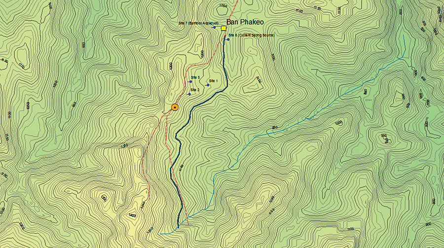
The people of Ban Phakeo were well aware of the disadvantage and danger in which their water situation placed them, but with an average annual household income of only US$150, they simply did not have the means to solve this critical problem themselves. The village, home to about 170 Hmong (an ethnic minority who live in the highlands of several Southeast Asian countries), is located more than two hours' walk from the nearest road, lacks any water or sanitation infrastructure, and is without electricity. Residents are subsistence farmers, growing or harvesting from the surrounding forests nearly everything they eat and a great deal of what they use in their daily lives. Ban Phakeo is located on the edge of the so-called "Plain of Jars," a landscape dotted throughout with hundreds of stone jars, some over three meters tall, and all estimated to be as much as two thousand years old. Though similar in most respects to scores of other highland villages in Laos, Ban Phakeo is unique in that it is situated in close proximity to one of the most extensive—and evocative—of these archaeological sites. The United Nations Educational, Scientific and Cultural Organization (UNESCO) has engaged in a multiyear project to improve living conditions and economic opportunities at Ban Phakeo and other communities located within a proposed Plain of Jars World Heritage Site. The Fort Lewis College (Durango, Colorado) chapter of Engineers Without Borders (EWB) has partnered with UNESCO to address the most pressing of the region's infrastructure needs, including the construction of a water system in Ban Phakeo. In May 2008, this first critical step was accomplished, and for the first time, the village now enjoys an ample supply of clean drinking water. Designing and constructing a water system, even one that meets the simple, sustainable, appropriate technology requirements of development in communities like Ban Phakeo, requires a great deal of data. Distances and elevation differentials between potential water sources and the community; the layout and demographics of the community; the location and nature of potential terrain obstacles; the best sites for storage tanks and water taps; and the locations where pressure break tanks, air release valves, and other pipeline components will be needed are all important considerations. As a result, detailed and accurate mapping of the project area is typically a critical first step in the process. In Ban Phakeo, ArcGIS technology—especially ArcPad mobile GIS—proved to be an essential tool.
Engineers Without Borders is a national nonprofit organization comprising both professional and student chapters from throughout the country. Thus far, EWB groups have completed more than 170 projects in 41 countries. The Fort Lewis College chapter (EWB-FLC) was founded in 2004 and has since constructed water systems in rural communities in Thailand and Ecuador. The 2008 project in Ban Phakeo represents the first phase of a multiyear commitment to at least six villages in Laos' Plain of Jars region. EWB-FLC is a multidisciplinary group of Fort Lewis College students, former students and faculty, and professional partners from the Durango area. In December 2007, two EWB-FLC team members traveled to Ban Phakeo to identify and map potential water sources and pipeline routes. At first, villagers suggested a variety of small water seeps in the vicinity of the village as possible sources for the new system. Taken together, it was estimated that seven of these seeps could probably supply sufficient water for the village, but the quality of several of these sources was questionable, and the need to build a system of pipelines from each of the seven sites to central storage tanks would be complex given the mountainous terrain surrounding the village. After an evening of discussion, village leaders mentioned a small stream that they knew had good, clean water but that was thought to be too far away. Given the uncertainty of the seeps, the team decided to examine this stream and make detailed measurements of its distance and elevation differential from the village. Integrating GPS data collection with ArcGIS mapping and analysis capabilities, ArcPad 7 software allowed the team to quickly calculate that the stream was near enough to the village, and could be intercepted at a high enough elevation, to be a feasible water source. Community leaders were again consulted, and they agreed that villagers would be willing to both dig the necessary pipeline trench and protect the stream's upper watershed from any human use. Having thus identified the water source, the next step was to identify the best route for the pipeline. Given that the water system would be a gravity-fed pipeline without any pumps, this step required careful attention. The problem, however, was that steep terrain and extremely dense tropical vegetation made this very difficult to accomplish on the ground.
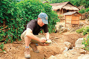
Upon returning to Colorado, team members turned to ArcGIS software to help resolve the pipeline routing problem. A detailed topographic map would have answered most questions, but it isn't possible to obtain such a map for this portion of Laos. Instead, a 90-meter digital elevation model (DEM) generated in 2000 during the Shuttle Radar Topography Mission (SRTM) was obtained and converted into a 10-meter interval topographic map using the ArcGIS Spatial Analyst extension. Though a map created from a DEM with a 90-meter resolution is somewhat generalized, the topographic output was compared with GPS data points and photos collected during the December trip and found to be sufficiently accurate for the pipeline design. With this information in hand, it was now possible to stake the pipeline route and purchase the correct quantities of pipe and other materials needed for what would be a nearly four-kilometer pipeline. One team member returned to Ban Phakeo in March and completed these tasks. A 12-person team arrived in Ban Phakeo in early May to undertake the construction of the water system. Again, GPS technology and ArcPad 7 played an important role in the project. While villagers had just finished digging the pipeline trench, locations, elevations, and distances required verification before work could get under way. Using a TopCon GMS-2 GPS receiver, the necessary data was easily collected despite rugged terrain and very dense vegetation. The GMS-2's ability to track both the American NavStar and Russian GLONASS GPS satellite constellations, allowing for excellent signal strength despite the landscape obstacles, proved essential to this process. For 11 days, the team worked side by side with villagers to transport materials, set and glue PVC pipe, construct a stream diversion structure, and build tap stands. Throughout the process, detailed mapping using ArcPad continued, including a detailed as-built survey of the pipeline and its components, demographic mapping of each village household, and collection of site measurements for preferred locations of the seven new latrines EWB-FLC plans to construct in 2009. For the first time, villagers have as much water as they need whenever they need it and can drink that water without worrying about whether or not they will become sick from it. With taps situated within the village, individuals spend less time and energy fetching their household water supplies, their personal hygiene is improved, and their overall health less at risk. About the AuthorJeff La Frenierre has been a member of Engineers Without Borders—Fort Lewis College since 2004. He has participated in assessment and project implementation trips in Thailand, Ecuador, and Laos. He is currently a graduate student at the University of Denver, Colorado, in the Department of Geography. More InformationFor additional information about the efforts of Engineers Without Borders—Fort Lewis College, visit www.fortlewis.edu/academics/school_arts_sciences/ physics_engineering/ewb_webpage/ewbflc.htm or contact Don May (tel.: 970-247-7545). For more information about Engineers Without Borders in general, or to find a chapter near you, visit www.ewb-usa.org. To learn more about the Plain of Jars and UNESCO's sustainable development initiative, visit www.unescobkk.org/index.php?id=2945. |