In May 2012, the ancient cities of Modena and Ferrara in northern Italy were struck by a devastating earthquake. While the loss of life, property, and emblematic heritage structures was severe, the Italian National Institute for Environmental Protection and Research (ISPRA) provided support to the Italy Department of Civil Protection for emergency response activities by helping prevent or manage any potential loss of containment of dangerous substances from industrial plants in the area hit by the earthquake.
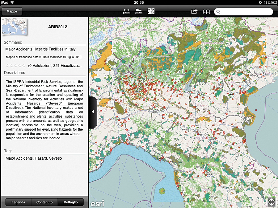
Through a simple web application based on GIS, ISPRA monitored high-risk establishments in the area by sharing information on types of activity, hazardous substances, geographic distribution in relation to the epicenter of the earthquake and nature conservation areas, and any damage suffered.

The Seveso Directive II
The GIS web application was built to help ISPRA comply with the 1996 European Union (EU) Seveso Directive II (named for an Italian town that suffered exposure to an accidental release of dioxin in 1976). The Seveso Directive II introduced important changes and new concepts in the prevention and mitigation of major incidents. The directive focuses on protection of the environment and covers substances considered dangerous for the environment. It introduced requirements relating to safety management systems, emergency plans, and land-use planning and tightened up the standards on inspections and public information. The requirements are applicable to any establishment where dangerous substances are present or likely to be produced, as a result of an accident, in quantities equal to or in excess of the quantities listed in the directive.
The Geoviewer That Could
The web application—currently only for use by the division inspectors—that has proved so useful is a simple but powerful geoviewer, using ArcGIS Online, that hosts and shares information on the geographic distribution of perimeters of industrial plants. It references Esri basemaps and the web map services relating to, respectively, the geographic distribution of Italy’s nature conservation areas hosted by SINAnet (the network of the environmental geographic information systems of ISPRA) and the geographic distribution of points representing epicenters of seismic activity in the national territory, updated in near real time and hosted by the National Institute of Geophysics and Volcanology working group LabGIS.
Bookmarks have been created for industrial sites with high concentrations of high-risk establishments (industrial parks). This is useful because it allows users to quickly navigate over areas with major environmental problems in the national territory.
In this framework, ArcGIS Online provides an easy way to support inspectors, emergency responders, and decision makers anywhere they are connected to the Internet, including through mobile devices (iOS, Android, Windows Mobile), giving a picture of potential interactions among high-risk companies present in Italy and the locations of historical and/or registered seismic events with reference to the map of seismic hazards in the national territory.
The application has proved particularly useful in the context of the critical support provided by technicians of Industrial Risk Division, as illustrated during the management of the seismic emergency—which occurred May 2012 in the Emilia Romagna region—at the Sala Situazioni Italia, the permanent crisis center set up in Rome by the Department of Civil Protection. Here, all national institutions, both public and private, involved in the civil protection system provide support, each based on its skills, during widespread natural disasters. Using the ArcGIS Online geoviewer, members of the Industrial Risk Division were provided with a real-time picture of companies potentially affected by the earthquake and were able to advise the teams of technicians on-site in the selection of priority sites on which to focus activities monitoring potential damage.
The National Inventory
Also in compliance with the Seveso Directive II, ISPRA’s Industrial Risk Division is responsible for the management and updating of the web-based National Inventory for major incidents involving hazardous chemicals, which it uses in conjunction with the geoserver. The National Inventory makes accessible on the web a set of data on establishments submitted by operators, including types of activities, amounts and types of stored substances, and damage scenarios and their impact outside plants, providing preliminary support for on-site inspection activities and hazards evaluation for the environment and population around major industrial sites. Operators also provide information about the geographic location of establishments that is successively processed, validated, and updated by ISPRA and the Ministry of Environment, Natural Resources and Sea to build the layer of perimeters for the more than 1,000 industrial plants in Italy.
What the Future Holds
At present, the application is used as a simple geoviewer. Soon, a buffer layer of damage areas with impacts outside the boundary of each industrial plant (derived from emergency plans) will be loaded to get a scenario of potentially impacted areas or targets due to a loss of containment of hazardous substances caused by the rupture or collapse of a unit following, for example, a seismic shock.
About the Authors
Francesco Astorri, geologist, graduated in 1994 and gained experience in the field of GIS by applying spatial analysis techniques to environmental risk assessment related to industrial activities. He has been working since 2000 at ISPRA (formerly the National Environmental Protection Agency), supporting the Ministry of Environment on major accident prevention and mitigation activities (EU Seveso Directives). Alberto Ricchiuti, chemical engineer, graduated in 1983 and has been working for 25 years at ISPRA in the field of hazard prevention and control. He has been with the Industrial Risk Division since 1997. He is a member of the Italian Association of Chemical Engineering, the European Federation of Chemical Engineering, and the American Association of Chemical Engineers.
For more information, contact Francesco Astorri, ISPRA, GIS specialist and SMS inspector for Seveso industrial plants, or Alberto Ricchiuti, head of Industrial Risk Division, ISPRA.

