The Next Generation of Network Management for Utility, Pipeline, and Telecommunications Companies
In The Sixth Wave, a book about the next (sixth) innovation boom, authors James Bradfield Moody and Bianca Nogrady argue that we are moving toward a starkly different society—a sort of new wave that will be driven by limited resources. To thrive, we must recycle, eliminate waste, and be more efficient.

Who will be affected by this new wave? Utility, pipeline, and telecommunications companies.
They currently deal with lower emissions requirements, millions of new sensors, rooftop solar panels, aging and obsolete assets, limited funding, conservation, real-time pricing, smart meters, smart grids, lower revenue, big data, reduced skill sets, and smaller workforces—all responses to limited resources.
The common thread in these challenges is the network’s relationship to location. Where are customers, sensors, meters, workers, and waste? That’s where GIS comes in.
A New Wave of GIS Network Management
Utility, pipeline, and telecommunications companies have used GIS to manage network asset data for decades. After all, knowing asset locations, their conditions, and their relationship to one another is fundamental to managing them. But the GIS data was often kept from the people who needed it most: fieldworkers, executives, managers, service technicians, and accountants.
In this new world of limited resources and increasingly complex networks, companies need a new wave of GIS-based network management with more functionality, added flexibility, and better access. That is why Esri is building the Utility Network in the ArcGIS platform.
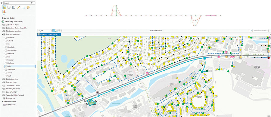
The Utility Network lets users create, manage, and share electric, water, wastewater, gas, district heating, and telecommunications asset data. The beta release of the Utility Network comes with base data models for electric, gas, and water networks. The technology is capable of supporting other networks—such as district heating, telecommunications, and wastewater—but, for now, users need to build their own data models or rely on partners. Esri will provide base data models in some of these areas in later releases.
The Utility Network is fast. It can handle billions of data elements with ease. Moreover, as part of the ArcGIS platform, the Utility Network will be available on any device, anytime, anywhere. Workers will be able to edit and trace the path of the network data in the field. The technology can handle modern data needs and makes it easy to share information securely with those who need it.

Here’s what else the Utility Network offers:
- Flexibility: Users can edit the network data seamlessly via web services.
- Asset connectivity: Users can mine the behavior of networks. For example, the technology can simulate the connection of a pipe to a valve or a transformer to an electrical conductor. This can be done automatically by placing the network elements at the same location or by specifying which objects are connected to each other.
- Containment: Users can place objects or devices within structures, such as buildings or cabinets. For example, the Utility Network can show the internal electrical connections of a substation inside the substation building or the internal gas piping configuration within a gas meter station building.
- Attachment: Users can model network element attachments, such as how a transformer or telephone cable is affixed to a pole.
- Quality: The technology leverages built-in, industry-standard rules that guard against users making data entry mistakes. Editors would not be allowed to connect a high-voltage cable to a low-voltage one, for example.
- Modeling: Users can specify where sources of electricity, gas, or water are located to facilitate network simulation. They can also model devices that have many connection points, such as complex switches and valves.
Esri is building the Utility Network to give utility, pipeline, and telecommunications customers what they have been asking for, which includes
- Increased productivity: Users have access to shortcuts, templates, and streamlined workflows within the software.
- Tracing: The technology contains extensive, out-of-the-box tracing tools.
- Visualization: The Utility Network supports 3D.
- Schematics: It has an assortment of built-in network diagrams and one-line tools (schematic representations of electric, water, and gas networks).
- Workflows: The Utility Network helps users with editing, giving them guidance at every step of the process. The technology continues to support the concept of long transactions as well, which enable users to create future changes to the network model that go into effect after a certain time.
Using the Utility Network
The Utility Network operates directly in ArcGIS Pro. (There are currently no plans to offer it in ArcMap.) Whereas formerly, ArcGIS Pro users could only view geometric networks (which model utility networks), this new software now allows users to edit networks. It also offers tools to extract data from existing data sources, such as Esri’s geometric network, and transforms the data so it automatically conforms to the Utility Network’s industry-standard data models. Users can then extend these base data models to fit other types of devices, rules, and configurations either by customizing them or employing partner solutions.
The best way to prepare for using the Utility Network is to follow these simple steps:
- Upgrade to the current release of ArcGIS, including ArcGIS Desktop 10.2.1.
- Get familiar with ArcGIS Pro, which is part of ArcGIS Desktop.
- Create groups and organizations in ArcGIS Online or ArcGIS Enterprise so the data modeled in the Utility Network is available to a range of users on any device.
- Download industry-specific solutions, as these work seamlessly with the Utility Network.
- Convert customized ArcMap apps into simple apps using tools such as Web AppBuilder for ArcGIS and AppStudio for ArcGIS, as well as industry-specific templates. Doing this before migrating to the Utility Network will ensure a smooth transition to the ArcGIS platform and the Utility Network.
The Next, Smarter Wave of Utilities
The Utility Network’s release comes as forward-thinking organizations reenvision how they use GIS. These companies are building information systems that engage users with modern functionality, allowing their employees to have access to data anytime, anywhere, on any device.
This new vision of getting information to anyone at any time enables people and organizations to make better use of limited resources. Companies that employ the Utility Network will manage their assets more efficiently and with enviable flexibility. It is the next, smarter wave of utility management.
Learn more about utility network management and receive information about the Utility Network.

