Indian Local Government Improves Governance and Service Efficiencies
Bengaluru (formerly known as Bangalore) is the third most populous city, the fifth most populous urban agglomeration, and the second fastest-growing major metropolis in India. Its government, Bruhat Bengaluru Mahanagara Palike (BBMP), Karnataka, is India’s fourth-largest local government.
A demographically diverse city, Bengaluru is well known as the hub of India’s information technology sector and has shown tremendous growth in the sector, accounting for more than 35 percent of India’s software exports. Because of its position as the nation’s leading IT exporter, Bengaluru is regarded as the Silicon Valley of India. Furthermore, the city is home to many well-recognized educational and research institutions in India, and it is therefore also known as the knowledge capital of the country. So it is no wonder that Bengaluru is rated among the top 10 preferred entrepreneurial locations in the world (Economic Times, April 2012).

Business Situation
Critical governance decisions being largely dependent on geographically disparate data, BBMP realized the importance of GIS for efficient information collection, management, and analysis. The city, having always been a promoter of advanced technology, was looking to leverage the best of GIS technology for its transformation initiative. Given this background, BBMP reached out to CyberTech Systems and Software Ltd., an Esri Gold Tier Partner headquartered in Trevose, Pennsylvania, with offices worldwide, including Thane West, Maharashtra, India. The company’s long-standing partnership with Esri made the CyberTech-Esri combination the preferred choice for BBMP. It made sense to leverage the GeoCivic platform, CyberTech’s ArcGIS software-based application suite that caters to the end-to-end needs of local governments in India, to drive the GIS transformation initiative.
The Bengaluru government identified the following functions as key drivers of the city’s social and economic growth:
- Property tax management
- Road infrastructure management
- Road cutting approval system
- Optical fiber cable (OFC) license issue management
- Citizen complaint redress
- Birth and death registration
These functions were thus chosen as the primary candidates for the GIS transformation drive, and CyberTech helped the government capture the locational intelligence residing in the data.
Property Tax Management
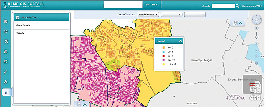
BBMP has geoenabled all properties in its jurisdiction. CyberTech is now providing all the necessary tools to efficiently administer and monitor the collection process. The tools and analytical engine will provide the data in a GIS for optimal and efficient management. Through improved record keeping of properties and increased tax compliance, the GeoCivic framework will help BBMP maximize coverage and thus augment government revenues.
One of the major benefits of the system was seen by the significant increase in the realized revenues. In 2007–08, 740,000 properties were covered with revenue collection of 4.48 billion rupees. In 2012–13, after the GIS transformation, the figures shot to a total of 1.62 million properties identified with revenue collection of 13.5 billion rupees. The current target is 20 billion rupees.
The system also brings about the much-needed transparency in property tax levy and collection. Automated workflows increase process efficiencies, while advanced analytics and GIS reporting with detailed dashboards facilitate better-informed decision making.
BBMP, with the help of the system, can now also offer advanced services to help citizens view their property information and pay their property taxes online.

Road Information System
Through the GIS transformation, BBMP is better managing its nearly 13,500-kilometer road network, providing a more organized management of geographically diverse road information. The system provided centralized, dynamic registration of accurate spatial and linear locations of road assets, enabling easy recording and modification of data. These asset attributes can now be visually represented through dynamic, thematic maps to help provide more efficient planning and predictive road maintenance. This not only saves a lot of time and effort, it also gives better control over project execution and saves a significant amount of maintenance costs.
An important aspect of this transformation was the dynamic road history update and maintenance. It helped BBMP officials keep track of road asset history, including all spatial and nonspatial changes made to the assets so far, thus helping them further ensure accurate and timely planning decisions.
Road Cutting Approval System
BBMP, on a regular basis, also had to manually manage the permissions and monitoring of road cutting activities carried out by various service providers (telecom, electricity, water supply, etc.) and by private property owners. The move to GeoCivic and the ArcGIS platform automated and streamlined the entire road cutting approval and management process. Through high-quality vector maps, the system now gives BBMP an integrated, spatial view of the proposed roadwork and helps officials approve, monitor, and maintain road cutting activities. Through advanced GIS and management information system reports, the system also helps users analyze pending projects and track them through completion, consequently enabling better-informed planning decisions.
Optical Fiber Cable Management
Over the past few years, the city had seen a tremendous increase in the laying of optical fiber cables by various service providers. Earlier, BBMP engineers and authorities faced numerous issues in continuously keeping track of these activities. BBMP officials can now easily track and monitor such projects, thereby enabling efficient revenue assessment and recognition. The ArcGIS software-based OFC Monitoring and Tracking System receives applications from prospective firms, manages approvals, accurately assesses revenues, and automatically issues demand notices. It is also integrated with the organization’s payment gateway, thus taking care of the entire process life cycle. With minimized revenue losses, this proved to be one of the major benefits of the GIS transformation.
Citizen Complaint Redress
BBMP now has an integrated geoenabled platform for easy and transparent citizen-government engagement. The application enables citizens to report and track service complaints and feedback through an easily accessible web portal. The system incorporates the geographic aspect of population spread to enhance and speed up the process of complaint redress and service provision. This not only made life more convenient for citizens, it also increased the public trust in the city government.
Birth and Death Registration
The GIS deployment also covered automation of birth and death registration processes with advanced thematic mapping and spatial analysis of the types and distribution of births and deaths across all zones in the city. This provided an important set of inputs for better public health administration in the city.
For more information, contact Sheshadri T., IT adviser, Bruhat Bengaluru Mahanagara Palike, Bengaluru or Vishal Bargat, director and head of India Business Unit, CyberTech Systems and Software Ltd..

