When we think about planning for future development, it’s common to focus on the locations and design of buildings. However, an equally important aspect often overlooked are the spaces in between buildings where people gather and move from place to place. Not only can these spaces provide opportunities for social interaction, recreation, and relaxation, but they can also contribute significant environmental benefits, such as improved air quality and reduction of the urban heat island effect. By intentionally designing these spaces to be inviting and accessible, we can create more livable communities.
In this blog post, we’re going to explore how ArcGIS Urban, particularly with its June 2024 updates, can be used to help design the spaces between buildings. We’ll use Pfingstweid Park in Zurich West, Switzerland as a practical example to show how a planner might leverage these new features and enhancements in their everyday work.

Brief history of Pfingstweid Park
Pfingstweid Park in Zurich West is a wonderful example of how urban spaces can adapt and change to meet the evolving needs of a community. Originally used as grazing land for cattle, this area became a community garden to provide local factory workers with land to grow their own produce – a valuable resource for residents during the post-World War I era.

The 1990s marked another significant transformation for Pfingstweid as the surrounding area transitioned from factories to residential and commercial developments. This change brought about a new set of needs, including educational and recreational facilities to serve the growing population. Following a community design competition, Pfingstweid Park opened in 2015, and Pfingstweid School followed in 2019. Today, Pfingstweid Park stands as an example of the city’s dedication to community-centered urban planning and design (Source).
Design new green space
Let’s imagine that we are urban planners at the City of Zurich tasked with evaluating the impact of potential park enhancements, including the addition of a soccer field and the expansion of green space, at Pfingstweid Park.
We will use a 3D model created with ArcGIS Urban to visualize and assess these proposed changes. This approach will help us understand the spatial dynamics and potential benefits of these enhancements before they’re implemented in the real-world.
Analyze spaces between buildings
Let’s start by assigning a space-use type to the park’s parcel to represent the ground coverage for the spaces between buildings. Space-use types in ArcGIS Urban help categorize parts of a building or area by their designated purpose. Each type comes with specific parameters that help calculate important metrics. For example, you can use the storage heat coefficient to compare different surface types, such as concrete, water, and green space.
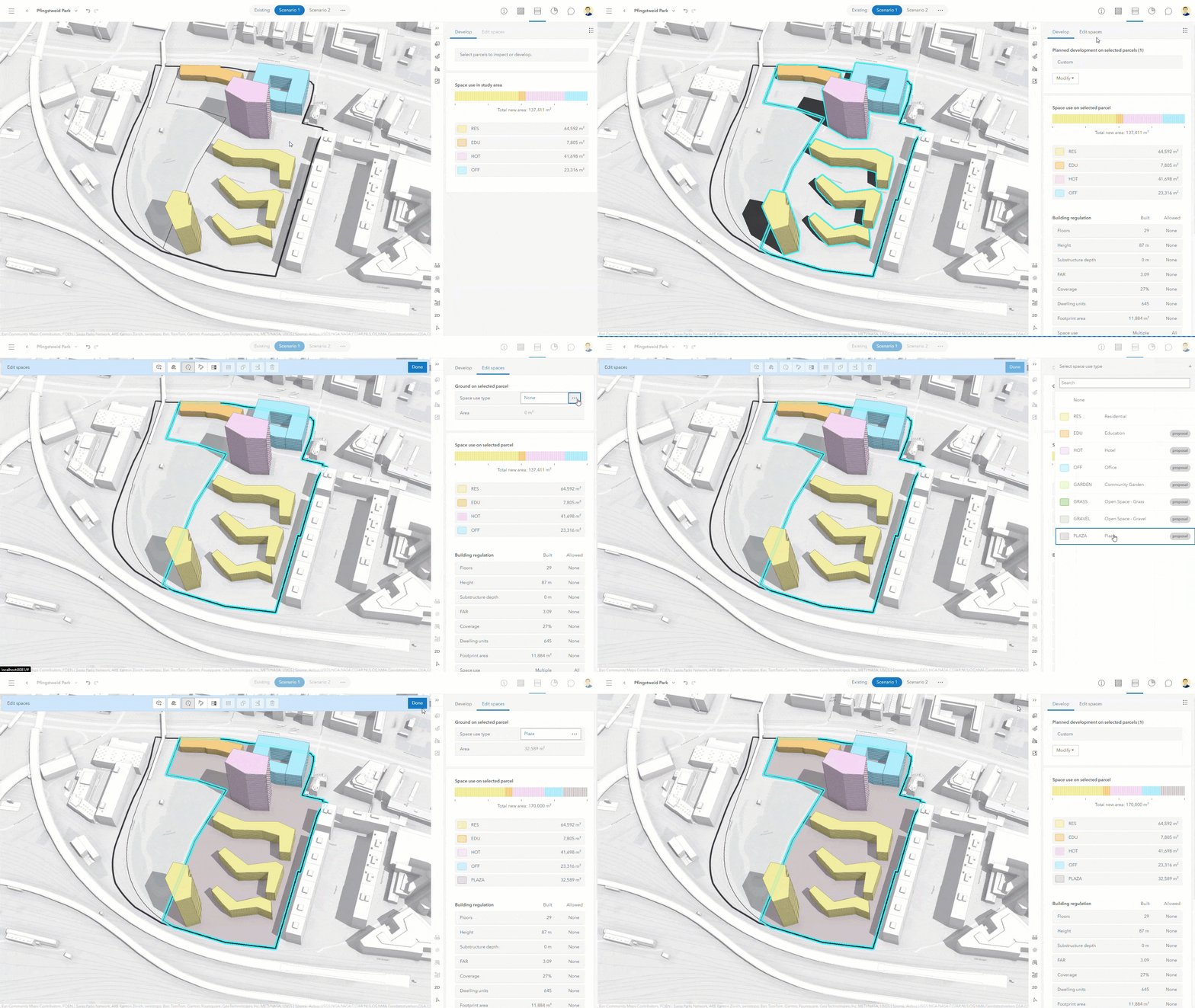
By categorizing the park’s ground coverage using a specific space-use type, in this case, PLAZA, we’re setting up the parcel for analysis to understand the impacts of potential modifications, like the addition of new buildings or surfaces.
Before the June update, you could only assign space-use types, such as residential, hotel, or retail, to either building or surface spaces. Now, you can also assign a space-use type to a whole parcel as ground space-use. This new feature allows you to label an entire parcel as grass, plaza, or any other type of surface, which enhances your ability to plan outdoor spaces with greater detail and accuracy.
Measure the impact of ground cover
In the previous section, we defined the initial layer of ground coverage as a plaza. Let’s now use the enhanced surface editing tools included in the June release to add more layers, specifically green spaces for the city’s gardeners to plant trees and flowers. These green spaces will help us to offset the potential impacts of an urban heat island caused by the plaza’s impervious concrete surface.
As we draw out these new green spaces, tooltips pop up showing exact measurements for each boundary—distance, area, and angle. This level of detail allows us to track the size and scale of surface changes, ensuring that our calculations for ground cover impact and usage are precise.
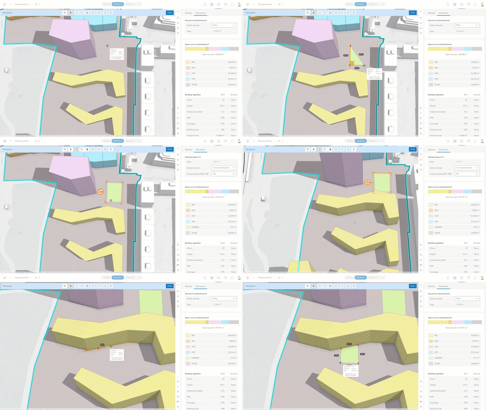
Additionally, ArcGIS Urban also makes sure that overlapping spaces aren’t counted twice in the space-use legend and other metrics. So, when we add new green spaces, they’re automatically deducted from the existing plaza ground coverage. If there are any discrepancies, an error warning appears, showing us where to take a closer look.
Design with the natural terrain
The new surface editing tools are particularly helpful when tracing outlines from contextual layers. For instance, consider a hand-drawn sketch of a drainage basin from a city design consultant. The newly enhanced editing tools allow for precise tracing, enabling us to accurately calculate the area coverage. This precision is key for analyzing the impact of different surfaces, like comparing grassy areas with garden spaces.
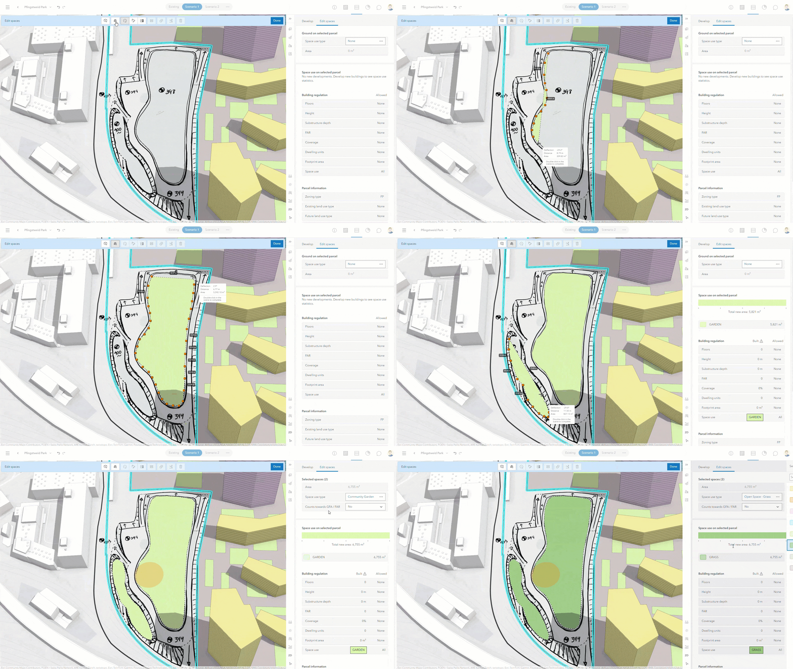
This release also introduces the ability to upload elevation layers to specific design scenarios. With this flexibility, we can now integrate elevation data directly into scenarios for more detail and context when designing spaces and surfaces.
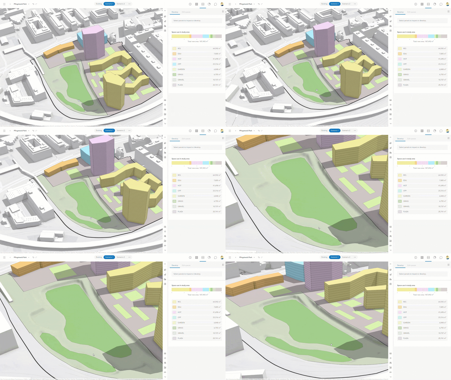
In this example, we’ve added an elevation layer to depict the natural depression in the landscape where the drainage basin is planned. This visualization shows us how we could manage runoff from impervious surfaces, like those found in the park’s plaza. Furthermore, calculations of the area help determine the necessary land extent to accommodate potential runoff. By integrating our surface designs with elevation layers, we’re able to model and visualize sustainable design practices more effectively.
Sketch with exact measurements
Finally, let’s explore the idea of adding a sports field adjacent to the school, situated on a flat patch of grass, that’s ideal for a game of soccer. Soccer fields for schools typically have specific sizes depending on the age ranges of the children playing on it. Thanks to the June release, we can now input exact dimensions to start sketching out the field with precision.
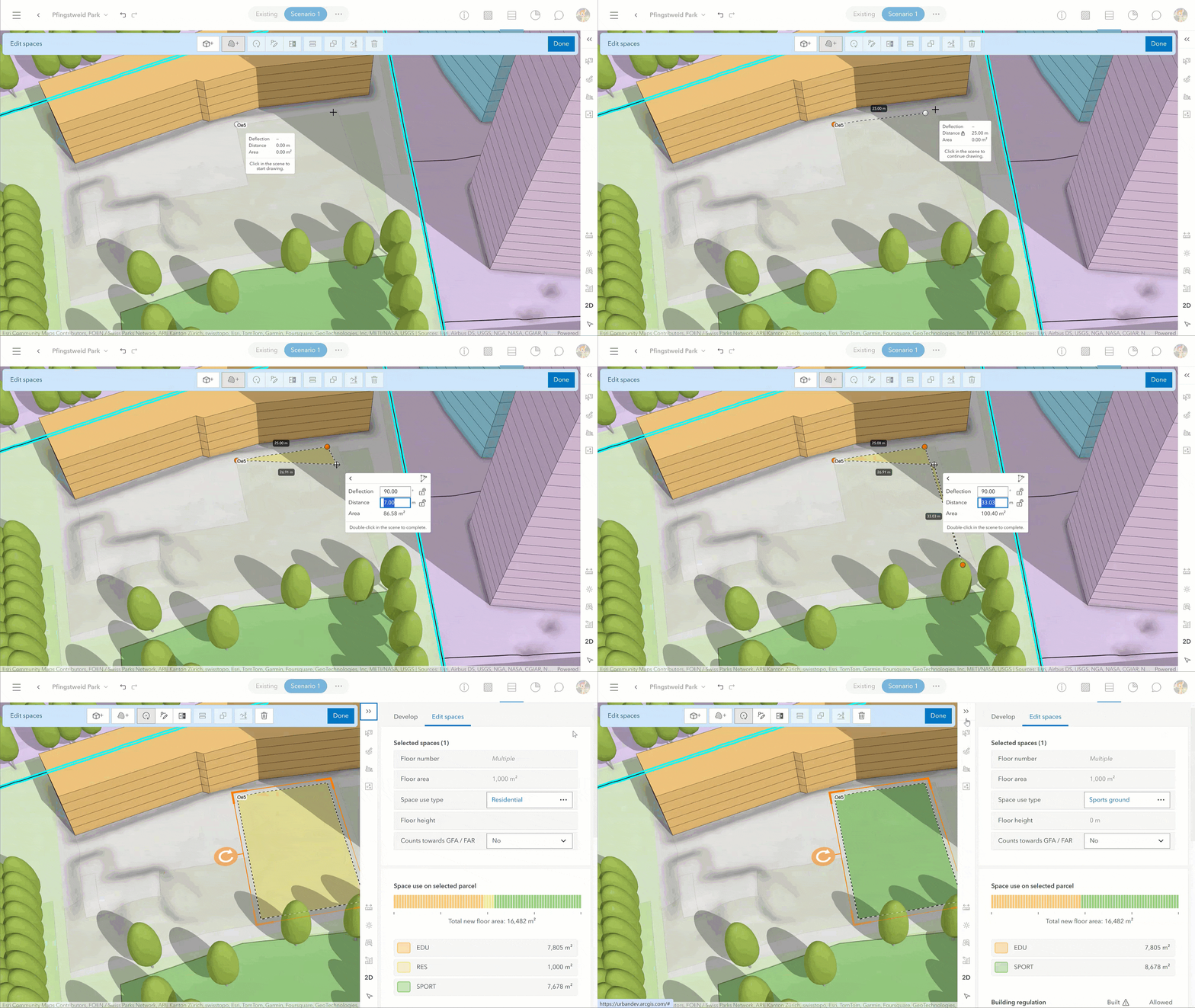
By overlaying the soccer field onto our 3D model of the park, alongside the detailed drainage basin model, we can assess how this new recreational area could interact with the natural landscape. Will the field remain well-drained after a heavy rain? How will it affect the nearby land? These are the kinds of questions we can begin to answer as we turn what began as a simple sketch into a vital part of the community’s daily life.
Summary of updates
- Create and apply space use types to parcels to represent ground space use.
- Add elevation layers directly to individual planning scenarios and see how different surfaces might interact with the terrain.
- Sketch and design surfaces, boundaries, and study areas with precision using tooltips and exact measurements.
- The parcel information in the overview now includes additional details on current and future land-use for parcels, providing deeper insights.
- Administrators of an ArcGIS Online organization can now copy urban models while persisting ownership of plans and project
For a complete list of new features, enhancements, and bug fixes, see the Release notes.
Additional updates
ArcGIS Urban at the 2024 Esri UC
Headed to San Diego for this year’s Esri User Conference? Be sure to stop by and see us in the Community Development space at the expo center. For a map and list of recommended sessions, check out our guide to all things ArcGIS Urban at this year’s UC.
ArcGIS Urban on ArcGIS Enterprise 11.3
In case you missed it, ArcGIS Urban is now available for deployment as an add-on to ArcGIS Enterprise, allowing you to host Urban on your organization’s own servers. Please note that the updates mentioned in this release are not included in Urban on Enterprise 11.3. For more information, about ArcGIS Urban on ArcGIS Enterprise, please see the related announcement.
Training resources & customer success stories
A selection of new and updated training resources is now available to help you make the most of Urban’s capabilities:
- New! Tutorial: Get started with ArcGIS Urban tutorial
- New! Tutorial: Design a resilient mixed-use neighborhood
- Recent updates to the ArcGIS Urban training catalog
- New! Houston examines options for low-cost housing development with ArcGIS Urban
As always, let us know if you have any questions by connecting with us on the ArcGIS Urban Esri Community page.


Commenting is not enabled for this article.